
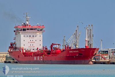
MRC MINA
Oil/Chemical Tanker
Current Trip
| Time Travelled | 6 days |
|---|---|
| Remaining Time | --- |
| Distance Travelled | 1164.51 nm |
| Remaining Distance | --- |
| AVG Speed | 10.5 Knots |
| MAX Speed | 11.8 Knots |
| AVG Wind | 11.2 knots |
| MAX Wind | 23 knots |
| MIN Temp | 3.2°C / 37.76°F |
| MAX Temp | 18.3°C / 64.94°F |
| Draught | 7.5 m |
| Position Received | 5 d ago |
Current Position
| Longitude | --- |
|---|---|
| Latitude | --- |
| Status | Under way using engine |
| Speed | 10.3 Knots |
| Course | 212.9° |
| Area | Aegean Sea |
| Station | T-AIS |
| Position Received | 5 d ago |
Info
Information
The current position of MRC MINA is in Aegean Sea with coordinates 36.83800° / 23.59830° as reported on 2025-12-28 16:25 by AIS to our vessel tracker app. The vessel's current speed is 10.3 Knots
The vessel MRC MINA (IMO: 9464285, MMSI: 248759000) is a Oil/Chemical Tanker that was built in 2009 ( 17 years old ). It's sailing under the flag of [MT] Malta.
In this page you can find informations about the vessels current position, last detected port calls, and current voyage information. If the vessels is not in coverage by AIS you will find the latest position.
The current position of MRC MINA is detected by our AIS receivers and we are not responsible for the reliability of the data. The last position was recorded while the vessel was in Coverage by the Ais receivers of our vessel tracking app.
The current draught of MRC MINA as reported by AIS is 7.5 meters
Weather
| Temperature | 18°C / 64.4°F |
|---|---|
| Wind Speed | 12 knots |
| Direction | 196° SSW |
| Pressure | 1008.4 hPa |
| Humidity | 55.3 % |
| Cloud Coverage | 18 % |
Featured Company
Last Port Calls
| Port | Arrival | Departure | Time In Port |
|---|---|---|---|
| 2025-12-24 19:31 | 2025-12-27 22:32 | 3 d | |
| 2025-12-21 00:42 | 2025-12-22 07:34 | 1 d | |
| 2025-12-18 06:36 | 2025-12-19 17:22 | 1 d | |
| 2025-12-16 17:17 | 2025-12-17 18:13 | 1 d | |
| 2025-12-13 18:11 | 2025-12-14 23:37 | 1 d | |
| 2025-12-04 16:25 | 2025-12-05 20:53 | 1 d |
Most Visited Ports (Last year)
| Port | Arrivals | |
|---|---|---|
| 4 | ||
| 3 | ||
| 3 | ||
| 2 | ||
| 2 | ||
| 2 |
Last Trips
| Origin | Departure | Destination | Arrival | Distance | |
|---|---|---|---|---|---|
| 2025-12-22 07:34 | 2025-12-24 19:31 | 698.40 nm | |||
| 2025-12-19 17:22 | 2025-12-21 00:42 | 367.92 nm | |||
| 2025-12-17 18:13 | 2025-12-18 06:36 | 146.22 nm | |||
| 2025-12-14 23:37 | 2025-12-16 17:17 | 86.23 nm | |||
| 2025-12-05 20:53 | 2025-12-13 18:11 | 1327.98 nm | |||
| 2025-10-23 19:12 | 2025-12-04 16:25 | 3697.79 nm |
Events
| Time | Event | Details | Position / Dest | Info |
|---|---|---|---|---|
| 2026-01-01 10:45 | STOP Moving | 4.95 nm, South East of BEJAIA |
36.71247 / 5.18537
DZBJA
|
Speed: 0.3 kn Course: 309° |
| 2026-01-01 08:25 | START Moving | 14.83 nm, North of ZIAMA MANSOURIA |
36.90588 / 5.36244
DZBJA
|
Speed: 5.7 kn Course: 211° |
| 2026-01-01 07:29 | STOP Moving | 14.72 nm, North of ZIAMA MANSOURIA |
36.90434 / 5.36383
DZBJA
|
Speed: 0.2 kn Course: 251° |
| 2025-12-28 16:28 | Status Changed | Default Under way using engine |
36.83200 / 23.59350
DZBJA
|
Speed: 10.3 kn Course: 212.9° |
| 2025-12-28 16:25 | Status Changed | Under way using engine Default |
36.83800 / 23.59830
DZBJA
|
Speed: 10.4 kn Course: 210° |
| 2025-12-28 16:25 | OUT of Coverage |
36.83800 / 23.59830
Aegean Sea
DZBJA
|
Speed: 10.3 kn Course: 212.9° |
|
| 2025-12-28 15:39 | Status Changed | Default Under way using engine |
36.95533 / 23.67583
DZBJA
|
Speed: 10.1 kn Course: 206.7° |
| 2025-12-28 15:31 | Status Changed | Under way using engine Default |
36.97500 / 23.68850
DZBJA
|
Speed: 10.6 kn Course: 209° |
| 2025-12-28 15:15 | Status Changed | Default Under way using engine |
37.01713 / 23.71643
DZBJA
|
Speed: 10.6 kn Course: 202.7° |
| 2025-12-28 15:05 | Status Changed | Under way using engine Default |
37.04371 / 23.73067
DZBJA
|
Speed: 10.6 kn Course: 202° |