

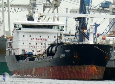
MANAS
Oil/Chemical Tanker

Current Trip
| Time Travelled | 7 days |
|---|---|
| Remaining Time | 6 days |
| Distance Travelled | 1981.29 nm |
| Remaining Distance | 1499.84 nm |
| AVG Speed | 10.2 Knots |
| MAX Speed | 13.8 Knots |
| AVG Wind | 15.8 knots |
| MAX Wind | 25 knots |
| MIN Temp | 13.4°C / 56.12°F |
| MAX Temp | 19.3°C / 66.74°F |
| Draught | 8 m |
| Position Received | 32 m ago |
Current Position
| Longitude | --- |
|---|---|
| Latitude | --- |
| Status | Under way using engine |
| Speed | 11.5 Knots |
| Course | 287.7° |
| Area | North Atlantic Ocean |
| Station | T-AIS |
| Position Received | 32 m ago |
Information
The current position of MANAS is in North Atlantic Ocean with coordinates 36.51383° / -8.60900° as reported on 2025-03-17 07:07 by AIS to our vessel tracker app. The vessel's current speed is 11.5 Knots and is heading at the port of HAMBURG. The estimated time of arrival as calculated by MyShipTracking vessel tracking app is 2025-03-23 10:01 LT
The vessel MANAS (IMO: 9447055, MMSI: 249498000) is a Oil/Chemical Tanker that was built in 2008 ( 17 years old ). It's sailing under the flag of [MT] Malta.
In this page you can find informations about the vessels current position, last detected port calls, and current voyage information. If the vessels is not in coverage by AIS you will find the latest position.
The current position of MANAS is detected by our AIS receivers and we are not responsible for the reliability of the data. The last position was recorded while the vessel was in Coverage by the Ais receivers of our vessel tracking app.
The current draught of MANAS as reported by AIS is 8 meters
Weather
| Temperature | 15.7°C / 60.26°F |
|---|---|
| Wind Speed | 18 knots |
| Direction | 223° SW |
| Pressure | 1010.8 hPa |
| Humidity | 77.5 % |
| Cloud Coverage | --- |


Featured Company
Last Port Calls
| Port | Arrival | Departure | Time In Port |
|---|---|---|---|
| 2025-03-03 14:06 | 2025-03-10 06:06 | 6 d | |
| 2025-02-18 02:55 | |||
| 2025-02-07 16:32 | 2025-02-09 07:36 | 1 d | |
| 2025-02-01 11:13 | 2025-02-04 10:53 | 2 d | |
| 2025-01-26 13:23 | 2025-01-29 22:18 | 3 d | |
| 2025-01-16 07:53 | 2025-01-17 19:20 | 1 d | |
| 2025-01-09 08:53 | 2025-01-11 05:37 | 1 d | |
| 2025-01-07 05:38 | 2025-01-08 14:49 | 1 d | |
| 2025-01-03 22:08 |
Most Visited Ports (Last year)
| Port | Arrivals | |
|---|---|---|
| 7 | ||
| 5 | ||
| 4 | ||
| 2 | ||
| 2 | ||
| 2 |
Last Trips
| Origin | Departure | Destination | Arrival | Distance | |
|---|---|---|---|---|---|
| 2025-02-18 03:55 | 2025-03-03 16:06 | 2145.28 nm | |||
| 2025-02-04 12:53 | 2025-02-07 17:32 | 860.21 nm | |||
| 2025-01-29 23:18 | 2025-02-01 13:13 | 548.16 nm | |||
| 2025-01-17 20:20 | 2025-01-26 14:23 | 2569.03 nm | |||
| 2025-01-11 07:37 | 2025-01-16 08:53 | 1347.40 nm | |||
| 2025-01-08 16:49 | 2025-01-09 10:53 | 15.63 nm | |||
| 2025-01-04 00:08 | 2025-01-07 07:38 | 24.55 nm |
Events
| Time | Event | Details | Position / Dest | Info |
|---|---|---|---|---|
| 2025-03-17 07:12 | Status Changed | Default Under way using engine |
36.51883 / -8.62633
EGALY>DEHAM
|
Speed: 11.5 kn Course: 287.7° |
| 2025-03-17 07:00 | Status Changed | Under way using engine Default |
36.50704 / -8.58586
EGALY>DEHAM
|
Speed: 11.3 kn Course: 293° |
| 2025-03-17 06:48 | Status Changed | Default Under way using engine |
36.49323 / -8.53999
EGALY>DEHAM
|
Speed: 10.5 kn Course: 282.2° |
| 2025-03-17 06:47 | Status Changed | Under way using engine Default |
36.49213 / -8.53621
EGALY>DEHAM
|
Speed: 11.4 kn Course: 291° |
| 2025-03-17 06:47 | Detected in Sea | Portuguese part of the North Atlantic Ocean |
36.49213 / -8.53621
North Atlantic Ocean
EGALY>DEHAM
|
Speed: 10.5 kn Course: 282.2° |
| 2025-03-17 06:36 | IN Coverage |
36.49213 / -8.53621
North Atlantic Ocean
EGALY>DEHAM
|
Speed: 10.5 kn Course: 282.2° |
|
| 2025-03-16 18:53 | Status Changed | Default Under way using engine |
35.97050 / -6.07050
EGALY>DEHAM
|
Speed: 9.7 kn Course: 267.9° |
| 2025-03-16 18:51 | OUT of Coverage |
35.97067 / -6.06400
North Atlantic Ocean
EGALY>DEHAM
|
Speed: 9.7 kn Course: 267.9° |
|
| 2025-03-16 18:49 | Status Changed | Under way using engine Default |
35.97083 / -6.05900
EGALY>DEHAM
|
Speed: 9.7 kn Course: 270° |
| 2025-03-16 18:36 | Status Changed | Default Under way using engine |
35.97033 / -6.01317
EGALY>DEHAM
|
Speed: 9.9 kn Course: 272.2° |