
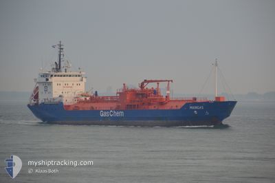
MAINGAS
Lpg Tanker
Current Trip
| Time Travelled | 1 day |
|---|---|
| Remaining Time | 10 h, 7 mins |
| Distance Travelled | 259.89 nm |
| Remaining Distance | 283.37 nm |
| AVG Speed | 8.9 Knots |
| MAX Speed | 15.4 Knots |
| AVG Wind | 17.2 knots |
| MAX Wind | 23 knots |
| MIN Temp | 9.4°C / 48.92°F |
| MAX Temp | 21.6°C / 70.88°F |
| Draught | 5.6 m |
| Position Received | 9 h, 13 m ago |
Current Position
| Longitude | 8.64381° |
|---|---|
| Latitude | 53.94684° |
| Status | Under way using engine |
| Speed | 15.2 Knots |
| Course | 314.2° |
| Area | North Sea |
| Station | T-AIS |
| Position Received | 9 h, 13 m ago |
Info
Information
The current position of MAINGAS is in North Sea with coordinates 53.94684° / 8.64381° as reported on 2024-05-02 22:19 by AIS to our vessel tracker app. The vessel's current speed is 15.2 Knots and is heading at the port of MOERDIJK. The estimated time of arrival as calculated by MyShipTracking vessel tracking app is 2024-05-03 17:39 LT
The vessel MAINGAS (IMO: 9108843, MMSI: 636016595) is a Lpg Tanker that was built in 2001 ( 23 years old ). It's sailing under the flag of [LR] Liberia.
In this page you can find informations about the vessels current position, last detected port calls, and current voyage information. If the vessels is not in coverage by AIS you will find the latest position.
The current position of MAINGAS is detected by our AIS receivers and we are not responsible for the reliability of the data. The last position was recorded while the vessel was in Coverage by the Ais receivers of our vessel tracking app.
The current draught of MAINGAS as reported by AIS is 5.6 meters
Weather
| Temperature | 11.7°C / 53.06°F |
|---|---|
| Wind Speed | 12 knots |
| Direction | 96° E |
| Pressure | 1003.4 hPa |
| Humidity | 95.3 % |
| Cloud Coverage | --- |
Featured Company
Last Port Calls
| Port | Arrival | Departure | Time In Port |
|---|---|---|---|
| 2024-04-30 22:35 | 2024-05-01 23:20 | 1 d | |
| 2024-04-25 09:22 | 2024-04-26 10:30 | 1 d | |
| 2024-04-18 20:24 | 2024-04-20 07:03 | 1 d | |
| 2024-04-08 01:17 | 2024-04-10 09:37 | 2 d | |
| 2024-04-01 21:58 | 2024-04-02 12:32 | 14 h | |
| 2024-03-30 09:11 | 2024-03-31 10:55 | 1 d | |
| 2024-03-22 22:32 | 2024-03-23 17:03 | 18 h | |
| 2024-03-16 12:12 | 2024-03-16 17:10 | 4 h | |
| 2024-03-06 18:56 | 2024-03-14 17:02 | 7 d | |
| 2024-03-03 15:57 | 2024-03-04 12:14 | 20 h |
Last Trips
| Origin | Departure | Destination | Arrival | Distance | |
|---|---|---|---|---|---|
| 2024-04-26 11:30 | 2024-05-01 00:35 | 624.82 nm | |||
| 2024-04-20 09:03 | 2024-04-25 10:22 | 217.08 nm | |||
| 2024-04-10 10:37 | 2024-04-18 22:24 | 1351.28 nm | |||
| 2024-04-02 14:32 | 2024-04-08 02:17 | 257.20 nm | |||
| 2024-03-31 11:55 | 2024-04-01 23:58 | 210.54 nm | |||
| 2024-03-23 18:03 | 2024-03-30 09:11 | 212.03 nm | |||
| 2024-03-16 18:10 | 2024-03-22 23:32 | 295.02 nm | |||
| 2024-03-14 18:02 | 2024-03-16 13:12 | 71.55 nm | |||
| 2024-03-04 13:14 | 2024-03-06 19:56 | 334.94 nm | |||
| 2024-03-02 19:35 | 2024-03-03 16:57 | 226.36 nm |
Events
| Time | Event | Details | Position / Dest | Info |
|---|---|---|---|---|
| 2024-05-02 22:20 | Status Changed | Default Under way using engine |
53.95122 / 8.63492
NL MOE
|
Speed: 15.2 kn Course: 314.2° |
| 2024-05-02 22:19 | OUT of Coverage |
53.94684 / 8.64381
North Sea
NL MOE
|
Speed: 15.2 kn Course: 314.2° |
|
| 2024-05-02 21:43 | ETA Changed | 2024/05/03 23:00 2024/05/03 22:00 |
53.84005 / 8.80126
NL MOE
|
Speed: 14.7 kn Course: 275.6° |
| 2024-05-02 20:42 | START Moving | 0.93 nm, South West of BRUNSBUETTEL |
53.89216 / 9.14123
NL MOE
|
Speed: 3.7 kn Course: 226° |
| 2024-05-02 20:40 | Detected in Sea | German part of the North Sea |
53.89299 / 9.14302
North Sea
NL MOE
|
Speed: 2.8 kn Course: 233.8° |
| 2024-05-02 20:06 | STOP Moving | 0.72 nm, South West of BRUNSBUETTEL |
53.89435 / 9.14571
NL MOE
|
Speed: 0.2 kn Course: 227° |
| 2024-05-02 19:35 | Status Changed | Under way using engine Default |
53.92050 / 9.19426
NL MOE
|
Speed: 6.6 kn Course: 219° |
| 2024-05-02 19:14 | Status Changed | Default Under way using engine |
53.95034 / 9.23527
NL MOE
|
Speed: 6.6 kn Course: 219.3° |
| 2024-05-02 19:00 | Status Changed | Under way using engine Default |
53.97118 / 9.26372
NL MOE
|
Speed: 6.6 kn Course: 219° |
| 2024-05-02 18:54 | Status Changed | Default Under way using engine |
53.97890 / 9.27407
NL MOE
|
Speed: 6.6 kn Course: 208.3° |