
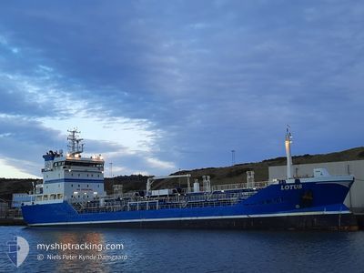
LOTUS
Oil/Chemical Tanker
Current Trip
KATTEGAT
| Time Travelled | 6 days |
|---|---|
| Remaining Time | --- |
| Distance Travelled | 850.04 nm |
| Remaining Distance | --- |
| AVG Speed | 9.4 Knots |
| MAX Speed | 13.7 Knots |
| AVG Wind | 18.2 knots |
| MAX Wind | 35 knots |
| MIN Temp | -3.3°C / 26.06°F |
| MAX Temp | 5.1°C / 41.18°F |
| Draught | 5 m |
| Position Received | 1 m ago |
Current Position
| Longitude | --- |
|---|---|
| Latitude | --- |
| Status | Under way using engine |
| Speed | 10.6 Knots |
| Course | 320° |
| Area | Kattegat |
| Station | T-AIS |
| Position Received | 1 m ago |
Info
Information
The current position of LOTUS is in Kattegat with coordinates 56.27383° / 12.28917° as reported on 2026-01-05 18:58 by AIS to our vessel tracker app. The vessel's current speed is 10.6 Knots
The vessel LOTUS (IMO: 9297137, MMSI: 266473000) is a Oil/Chemical Tanker that was built in 2004 ( 22 years old ). It's sailing under the flag of [SE] Sweden.
In this page you can find informations about the vessels current position, last detected port calls, and current voyage information. If the vessels is not in coverage by AIS you will find the latest position.
The current position of LOTUS is detected by our AIS receivers and we are not responsible for the reliability of the data. The last position was recorded while the vessel was in Coverage by the Ais receivers of our vessel tracking app.
The current draught of LOTUS as reported by AIS is 5 meters
Weather
| Temperature | -0.8°C / 30.56°F |
|---|---|
| Wind Speed | 12 knots |
| Direction | 110° ESE |
| Pressure | 1009.6 hPa |
| Humidity | 85.4 % |
| Cloud Coverage | 57 % |
Featured Company
Last Port Calls
| Port | Arrival | Departure | Time In Port |
|---|---|---|---|
| 2025-12-29 13:48 | 2025-12-30 02:17 | 12 h | |
| 2025-12-27 01:42 | 2025-12-28 14:13 | 1 d | |
| 2025-12-22 01:25 | 2025-12-22 14:41 | 13 h | |
| 2025-12-18 19:11 | 2025-12-22 00:47 | 3 d | |
| 2025-12-16 13:58 | 2025-12-17 23:07 | 1 d | |
| 2025-12-10 11:37 | 2025-12-13 06:40 | 2 d | |
| 2025-12-09 09:08 | 2025-12-09 22:25 | 13 h | |
| 2025-12-07 16:45 | 2025-12-08 01:31 | 8 h | |
| 2025-12-06 19:47 | 2025-12-07 03:25 | 7 h | |
| 2025-12-03 23:13 | 2025-12-04 20:09 | 20 h |
Last Trips
| Origin | Departure | Destination | Arrival | Distance | |
|---|---|---|---|---|---|
| 2025-12-28 14:13 | 2025-12-29 13:48 | 238.35 nm | |||
| 2025-12-22 14:41 | 2025-12-27 01:42 | 1080.36 nm | |||
| 2025-12-22 00:47 | 2025-12-22 01:25 | 2.26 nm | |||
| 2025-12-17 23:07 | 2025-12-18 19:11 | 200.22 nm | |||
| 2025-12-13 06:40 | 2025-12-16 13:58 | 623.88 nm | |||
| 2025-12-09 22:25 | 2025-12-10 11:37 | 141.88 nm | |||
| 2025-12-08 01:31 | 2025-12-09 09:08 | 141.79 nm | |||
| 2025-12-07 03:25 | 2025-12-07 16:45 | 135.98 nm | |||
| 2025-12-04 20:09 | 2025-12-06 19:47 | 522.14 nm | |||
| 2025-12-03 22:01 | 2025-12-03 23:13 | 7.59 nm |
Events
| Time | Event | Details | Position / Dest | Info |
|---|---|---|---|---|
| 2026-01-05 16:23 | ETA Changed | 2026/01/06 21:00 2026/01/04 21:00 |
55.89708 / 12.76628
KATTEGAT
|
Speed: 7.5 kn Course: 312° |
| 2026-01-05 16:18 | START Moving | 2.68 nm, North West of LANDSKRONA |
55.89323 / 12.77728
KATTEGAT
|
Speed: 3.2 kn Course: 319° |
| 2026-01-05 16:17 | Destination Changed | KATTEGAT DKKAL |
55.89253 / 12.77755
KATTEGAT
|
Speed: 0.8 kn Course: 327° |
| 2026-01-05 16:17 | Status Changed | Under way using engine At anchor |
55.89253 / 12.77755
DKKAL
|
Speed: 0.8 kn Course: 318° |
| 2026-01-03 13:02 | ETA Changed | 2026/01/04 21:00 2026/01/01 18:00 |
55.89070 / 12.77900
DKKAL
|
Speed: 0.4 kn Course: 306° |
| 2026-01-02 17:37 | Status Changed | At anchor Under way using engine |
55.89057 / 12.77882
DKKAL
|
Speed: 0.3 kn Course: 319° |
| 2026-01-02 17:32 | STOP Moving | 2.52 nm, North West of LANDSKRONA |
55.89045 / 12.77855
DKKAL
|
Speed: 0.3 kn Course: 343° |
| 2026-01-02 16:52 | Change Sea Area | Swedish part of the Kattegat Danish part of the Kattegat |
55.81267 / 12.73508
Kattegat
|
Speed: 12 kn Course: 22° |
| 2026-01-02 15:04 | Change Sea Area | Danish part of the Kattegat Swedish part of the Kattegat |
55.48475 / 12.70300
Kattegat
|
Speed: 11.5 kn Course: 2° |
| 2026-01-02 14:21 | Change Sea Area | Swedish part of the Kattegat Swedish part of the Baltic Sea |
55.34312 / 12.68233
Kattegat
|
Speed: 12.1 kn Course: 6° |