

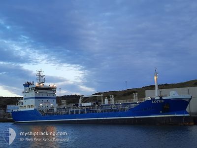
LOTUS
Oil/Chemical Tanker

Current Trip
| Time Travelled | 14 h, 19 mins |
|---|---|
| Remaining Time | 1 day |
| Distance Travelled | 163.60 nm |
| Remaining Distance | 336.64 nm |
| AVG Speed | 11.2 Noeuds |
| MAX Speed | 14.6 Noeuds |
| AVG Wind | 10.3 knots |
| MAX Wind | 15.7 knots |
| MIN Temp | 6.5°C / 43.7°F |
| MAX Temp | 11.2°C / 52.16°F |
| Tirant d eau | 4.8 m |
| Position reçue | 1 m depuis |
Current Position
| Longitude | --- |
|---|---|
| Latitude | --- |
| Etat | Under way using engine |
| Vitesse | 11.7 Noeuds |
| Parcours | 39° |
| Zone | North Sea |
| Station | T-AIS |
| Position reçue | 1 m depuis |
Information
The current position of LOTUS is in North Sea with coordinates 55.20237° / 3.42705° as reported on 2025-03-21 06:50 by AIS to our vessel tracker app. The vessel's current speed is 11.7 Noeuds and is heading at the port of GOTEBORG. The estimated time of arrival as calculated by MyShipTracking vessel tracking app is 2025-03-22 11:52 LT
The vessel LOTUS (IMO: 9297137, MMSI: 266473000) is a Oil/Chemical Tanker that was built in 2004 ( 21 Age ). It's sailing under the flag of [SE] Sweden.
In this page you can find informations about the vessels current position, last detected port calls, and current voyage information. If the vessels is not in coverage by AIS you will find the latest position.
The current position of LOTUS is detected by our AIS receivers and we are not responsible for the reliability of the data. The last position was recorded while the vessel was in Coverage by the Ais receivers of our vessel tracking app.
The current draught of LOTUS as reported by AIS is 4.8 meters
Weather
| Temperature | 6.5°C / 43.7°F |
|---|---|
| Wind Speed | 14 knots |
| Direction | 115° ESE |
| Pressure | 1019.2 hPa |
| Humidity | 80.3 % |
| Cloud Coverage | 74 % |


Featured Company
Last Port Calls
| Port | Arrival | Departure | Time In Port |
|---|---|---|---|
| 2025-03-19 14:54 | 2025-03-20 16:32 | 1 d | |
| 2025-03-16 03:24 | 2025-03-17 07:59 | 1 d | |
| 2025-03-12 23:06 | 2025-03-15 06:02 | 2 d | |
| 2025-03-07 18:27 | 2025-03-09 21:30 | 2 d | |
| 2025-02-22 15:13 | 2025-02-23 15:44 | 1 d | |
| 2025-02-20 00:06 | 2025-02-20 20:59 | 20 h | |
| 2025-02-11 00:08 | 2025-02-12 09:55 | 1 d | |
| 2025-02-08 14:34 | 2025-02-09 06:19 | 15 h | |
| 2025-02-04 07:20 | 2025-02-05 12:02 | 1 d | |
| 2025-02-02 23:22 | 2025-02-03 14:37 | 15 h |
Most Visited Ports (Last year)
| Port | Arrivals | |
|---|---|---|
| 43 | ||
| 18 | ||
| 12 | ||
| 9 | ||
| 8 | ||
| 6 |
Last Trips
| Origin | Departure | Destination | Arrival | Distance | |
|---|---|---|---|---|---|
| 2025-03-17 07:59 | 2025-03-19 14:54 | 606.50 nm | |||
| 2025-03-15 06:02 | 2025-03-16 03:24 | 195.73 nm | |||
| 2025-03-09 21:30 | 2025-03-12 23:06 | 327.93 nm | |||
| 2025-02-23 15:44 | 2025-03-07 18:27 | 871.09 nm | |||
| 2025-02-20 20:59 | 2025-02-22 15:13 | 436.97 nm | |||
| 2025-02-12 09:55 | 2025-02-20 00:06 | 407.22 nm | |||
| 2025-02-09 06:19 | 2025-02-11 00:08 | 427.37 nm | |||
| 2025-02-05 12:02 | 2025-02-08 14:34 | 49.37 nm | |||
| 2025-02-03 14:37 | 2025-02-04 07:20 | 104.73 nm | |||
| 2025-02-02 18:33 | 2025-02-02 23:22 | 54.71 nm |
Events
| Heure | Evenement | Détails | Position/ Destination | Info |
|---|---|---|---|---|
| 2025-03-21 05:01 | Changement de zone | Dutch part of the North Sea United Kingdom part of the North Sea |
54.92420 / 3.03035
North Sea
SE GOT
|
Vitesse: 11.7 kn Parcours: 39° |
| 2025-03-21 01:39 | Etat Changé | Under way using engine Default |
54.47265 / 2.22408
SE GOT
|
Vitesse: 11.7 kn Parcours: 47° |
| 2025-03-21 01:21 | Dans la zone couverte |
54.47308 / 2.22490
North Sea
SE GOT
|
Vitesse: 11.6 kn Parcours: 49° |
|
| 2025-03-20 20:09 | Etat Changé | Default Under way using engine |
53.77562 / .80195
SE GOT
|
Vitesse: 12.2 kn Parcours: 62° |
| 2025-03-20 20:00 | Hors de la zone couverte |
53.76167 / .75695
North Sea
SE GOT
|
Vitesse: 12.2 kn Parcours: 62° |
|
| 2025-03-20 16:32 | PORT DE DEPART |
|
53.62988 / -.15443
SE GOT
|
Vitesse: 6 kn Parcours: 117° |
| 2025-03-20 16:22 | Démarrage |
53.63260 / -.17995
[GB] IMMINGHAM
|
Vitesse: 4.5 kn Parcours: 75° |
|
| 2025-03-20 16:14 | Tirant d'eau modifié | 4.8 6.9 |
53.63073 / -.18132
[GB] IMMINGHAM
|
Vitesse: 0.5 kn Parcours: 296° |
| 2025-03-20 16:14 | Changement de destination | SE GOT GB IMM |
53.63073 / -.18132
[GB] IMMINGHAM
|
Vitesse: 0.5 kn Parcours: 296° |
| 2025-03-20 16:14 | Changement d'ETA | 2025/03/22 14:00 2025/03/19 13:00 |
53.63073 / -.18132
[GB] IMMINGHAM
|
Vitesse: 0.5 kn Parcours: 296° |