

LORD OF THE ISLES
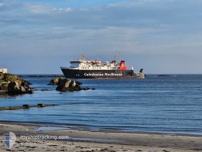
Ro-Ro/Passenger Ship

Current Trip
| Time Travelled | 17 mins |
|---|---|
| Remaining Time | 3 h, 51 mins |
| Distance Travelled | 2.00 nm |
| Remaining Distance | --- |
| AVG Speed | --- |
| MAX Speed | --- |
| AVG Wind | 15.7 knots |
| MAX Wind | 15.7 knots |
| MIN Temp | 6°C / 42.8°F |
| MAX Temp | 6°C / 42.8°F |
| Draught | 3.3 m |
| Position Received | 5 h, 15 m ago |
Current Position
| Longitude | --- |
|---|---|
| Latitude | --- |
| Status | Under way using engine |
| Speed | 15 Knots |
| Course | 304.5° |
| Area | Inner Seas off the West Coast of Scotland |
| Station | T-AIS |
| Position Received | 5 h, 15 m ago |
Information
The current position of LORD OF THE ISLES is in Inner Seas off the West Coast of Scotland with coordinates 56.49927° / -5.70877° as reported on 2025-03-18 07:44 by AIS to our vessel tracker app. The vessel's current speed is 15 Knots and is heading at the port of CRAIGNURE PIER. The estimated time of arrival as calculated by MyShipTracking vessel tracking app is 2025-03-18 16:51 LT
The vessel LORD OF THE ISLES (IMO: 8710869, MMSI: 232605000) is a Ro-Ro/Passenger Ship that was built in 1989 ( 36 years old ). It's sailing under the flag of [GB] United Kingdom.
In this page you can find informations about the vessels current position, last detected port calls, and current voyage information. If the vessels is not in coverage by AIS you will find the latest position.
The current position of LORD OF THE ISLES is detected by our AIS receivers and we are not responsible for the reliability of the data. The last position was recorded while the vessel was in Coverage by the Ais receivers of our vessel tracking app.
The current draught of LORD OF THE ISLES as reported by AIS is 3.3 meters
Weather
| Temperature | 5.7°C / 42.26°F |
|---|---|
| Wind Speed | 15 knots |
| Direction | 152° SSE |
| Pressure | 1026.3 hPa |
| Humidity | 59.7 % |
| Cloud Coverage | 50 % |


Featured Company
Last Port Calls
| Port | Arrival | Departure | Time In Port |
|---|---|---|---|
| 2025-03-18 12:20 | 2025-03-18 12:43 | 23 m | |
| 2025-03-18 11:00 | 2025-03-18 11:32 | 32 m | |
| 2025-03-18 09:52 | 2025-03-18 10:12 | 20 m | |
| 2025-03-17 17:51 | 2025-03-18 07:07 | 13 h | |
| 2025-03-17 16:49 | 2025-03-17 17:14 | 25 m | |
| 2025-03-17 15:33 | 2025-03-17 16:16 | 42 m | |
| 2025-03-17 12:23 | 2025-03-17 12:44 | 20 m | |
| 2025-03-17 10:56 | 2025-03-17 11:32 | 35 m | |
| 2025-03-17 09:47 | 2025-03-17 10:07 | 20 m | |
| 2025-03-16 17:34 | 2025-03-17 07:05 | 13 h |
Most Visited Ports (Last year)
| Port | Arrivals | |
|---|---|---|
| 178 | ||
| 156 | ||
| 151 | ||
| 135 | ||
| 90 | ||
| 79 |
Last Trips
| Origin | Departure | Destination | Arrival | Distance | |
|---|---|---|---|---|---|
| 2025-03-18 11:32 | 2025-03-18 12:20 | 11.39 nm | |||
| 2025-03-18 10:12 | 2025-03-18 11:00 | 11.58 nm | |||
| 2025-03-18 07:07 | 2025-03-18 09:52 | 40.80 nm | |||
| 2025-03-17 17:14 | 2025-03-17 17:51 | 8.18 nm | |||
| 2025-03-17 16:16 | 2025-03-17 16:49 | 8.28 nm | |||
| 2025-03-17 12:44 | 2025-03-17 15:33 | 39.46 nm | |||
| 2025-03-17 11:32 | 2025-03-17 12:23 | 11.28 nm | |||
| 2025-03-17 10:07 | 2025-03-17 10:56 | 11.32 nm | |||
| 2025-03-17 07:05 | 2025-03-17 09:47 | 39.85 nm | |||
| 2025-03-16 14:44 | 2025-03-16 17:34 | 40.23 nm |
Events
| Time | Event | Details | Position / Dest | Info |
|---|---|---|---|---|
| 2025-03-18 12:44 | START Moving | 0.62 nm, South East of COLL |
56.60858 / -6.50518
GB AGO
|
Speed: 14.4 kn Course: 89° |
| 2025-03-18 12:43 | PORT DEPARTURE |
|
56.60858 / -6.50518
GB AGO
|
Speed: 4.1 kn Course: 136° |
| 2025-03-18 12:28 | STOP Moving |
56.61409 / -6.52186
[GB] COLL
|
Speed: Course: 130° |
|
| 2025-03-18 12:20 | PORT ARRIVAL |
|
56.61323 / -6.52095
[GB] COLL
|
Speed: 11.9 kn Course: 351° |
| 2025-03-18 11:32 | START Moving | 0.75 nm, East of SCARINISH |
56.50663 / -6.77511
GB AGO
|
Speed: 15 kn Course: 105° |
| 2025-03-18 11:32 | PORT DEPARTURE |
|
56.50663 / -6.77511
GB AGO
|
Speed: 3.2 kn Course: 95° |
| 2025-03-18 11:04 | STOP Moving |
56.51021 / -6.79662
[GB] SCARINISH
|
Speed: Course: 97° |
|
| 2025-03-18 11:00 | PORT ARRIVAL |
|
56.51183 / -6.79692
[GB] SCARINISH
|
Speed: 12.2 kn Course: 296° |
| 2025-03-18 10:12 | START Moving | 0.7 nm, South of COLL |
56.60344 / -6.51345
GB AGO
|
Speed: 14.6 kn Course: 182° |
| 2025-03-18 10:12 | PORT DEPARTURE |
|
56.60344 / -6.51345
GB AGO
|
Speed: 0.3 kn Course: 128° |