

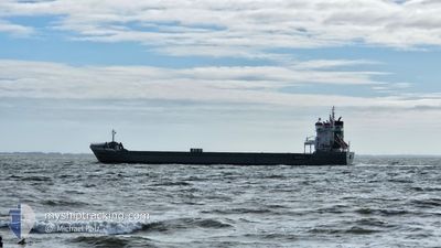
KWINTEBANK
General Cargo

Current Trip
SARAYLAR
| Time Travelled | 7 h, 4 mins |
|---|---|
| Remaining Time | --- |
| Distance Travelled | --- |
| Remaining Distance | --- |
| AVG Speed | --- |
| MAX Speed | --- |
| AVG Wind | --- |
| MAX Wind | --- |
| MIN Temp | --- |
| MAX Temp | --- |
| Draught | 4.5 m |
| Position Received | 3 d ago |
Current Position
| Longitude | --- |
|---|---|
| Latitude | --- |
| Status | Under way using engine |
| Speed | 12.2 Knots |
| Course | 270.7° |
| Area | Sea of Marmara |
| Station | T-AIS |
| Position Received | 3 d ago |
Information
The current position of KWINTEBANK is in Sea of Marmara with coordinates 40.67604° / 27.87841° as reported on 2025-03-25 04:22 by AIS to our vessel tracker app. The vessel's current speed is 12.2 Knots
The vessel KWINTEBANK (IMO: 9234288, MMSI: 245864000) is a General Cargo that was built in 2002 ( 23 years old ). It's sailing under the flag of [NL] Netherlands.
In this page you can find informations about the vessels current position, last detected port calls, and current voyage information. If the vessels is not in coverage by AIS you will find the latest position.
The current position of KWINTEBANK is detected by our AIS receivers and we are not responsible for the reliability of the data. The last position was recorded while the vessel was in Coverage by the Ais receivers of our vessel tracking app.
The current draught of KWINTEBANK as reported by AIS is 4.5 meters
Weather
| Temperature | 10.3°C / 50.54°F |
|---|---|
| Wind Speed | 2 knots |
| Direction | 98° E |
| Pressure | 1003.5 hPa |
| Humidity | 92.1 % |
| Cloud Coverage | 100 % |


Featured Company
Last Port Calls
| Port | Arrival | Departure | Time In Port |
|---|---|---|---|
| 2025-03-25 14:39 | 2025-03-28 09:17 | 2 d | |
| 2025-03-20 19:23 | 2025-03-25 01:00 | 4 d | |
| 2025-03-14 12:49 | 2025-03-16 06:01 | 1 d | |
| 2025-03-06 17:50 | 2025-03-06 22:56 | 5 h | |
| 2025-02-23 13:23 | 2025-02-28 15:03 | 5 d | |
| 2025-02-07 07:33 | 2025-02-09 16:43 | 2 d | |
| 2025-01-30 01:20 | 2025-02-04 20:56 | 5 d | |
| 2025-01-23 21:45 | 2025-01-30 01:17 | 6 d | |
| 2025-01-18 09:23 | 2025-01-18 11:04 | 1 h | |
| 2025-01-18 05:49 | 2025-01-18 08:55 | 3 h |
Last Trips
| Origin | Departure | Destination | Arrival | Distance | |
|---|---|---|---|---|---|
| 2025-03-25 01:00 | 2025-03-25 14:39 | 87.91 nm | |||
| 2025-03-16 06:01 | 2025-03-20 19:23 | 865.76 nm | |||
| 2025-03-06 22:56 | 2025-03-14 12:49 | 2043.49 nm | |||
| 2025-02-28 15:03 | 2025-03-06 17:50 | 1692.93 nm | |||
| 2025-02-09 16:43 | 2025-02-23 13:23 | 2125.80 nm | |||
| 2025-02-04 20:56 | 2025-02-07 07:33 | 759.42 nm | |||
| 2025-01-30 01:17 | 2025-01-30 01:20 | 0.03 nm | |||
| 2025-01-18 11:04 | 2025-01-23 21:45 | 888.30 nm | |||
| 2025-01-18 08:55 | 2025-01-18 09:23 | 0.58 nm | |||
| 2025-01-15 13:57 | 2025-01-18 05:49 | 714.52 nm |
Events
| Time | Event | Details | Position / Dest | Info |
|---|---|---|---|---|
| 2025-03-28 06:17 | PORT DEPARTURE |
|
40.69064 / 27.63942
SARAYLAR
|
Speed: 3.5 kn Course: 2° |
| 2025-03-28 06:12 | START Moving |
40.65882 / 27.66408
[TR] SARAYLAR
|
Speed: 3.5 kn Course: 2° |
|
| 2025-03-25 11:57 | STOP Moving |
40.65671 / 27.66165
[TR] SARAYLAR
|
Speed: Course: 58° |
|
| 2025-03-25 11:39 | PORT ARRIVAL |
|
40.65681 / 27.66396
[TR] SARAYLAR
|
Speed: 3.9 kn Course: 189° |
| 2025-03-25 11:18 | START Moving | 0.88 nm, North of SARAYLAR |
40.67303 / 27.66473
SARAYLAR
|
Speed: 3.1 kn Course: 124° |
| 2025-03-25 05:35 | STOP Moving | 0.93 nm, North of SARAYLAR |
40.67293 / 27.65678
SARAYLAR
|
Speed: 0.3 kn Course: 284° |
| 2025-03-25 04:34 | Status Changed | Default Under way using engine |
40.67664 / 27.82369
SARAYLAR
|
Speed: 12.2 kn Course: 270.7° |
| 2025-03-25 04:22 | OUT of Coverage |
40.67604 / 27.87841
Sea of Marmara
SARAYLAR
|
Speed: 12.2 kn Course: 270.7° |
|
| 2025-03-24 22:00 | Status Changed | Under way using engine Moored |
40.76022 / 29.52163
SARAYLAR
|
Speed: 4.6 kn Course: 232° |
| 2025-03-24 22:00 | PORT DEPARTURE |
|
40.76066 / 29.52231
SARAYLAR
|
Speed: 3.2 kn Course: 233° |