
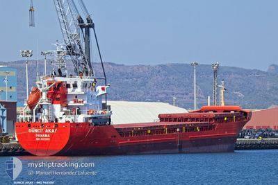
GUNCE AKAY
General Cargo
Current Trip
| Time Travelled | 3 days |
|---|---|
| Remaining Time | --- |
| Distance Travelled | 851.27 nm |
| Remaining Distance | --- |
| AVG Speed | 10.5 Knots |
| MAX Speed | 12.4 Knots |
| AVG Wind | 10.2 knots |
| MAX Wind | 20.2 knots |
| MIN Temp | 13.1°C / 55.58°F |
| MAX Temp | 17.7°C / 63.86°F |
| Draught | 6.4 m |
| Position Received | 20 h, 59 m ago |
Current Position
| Longitude | --- |
|---|---|
| Latitude | --- |
| Status | Under way using engine |
| Speed | 11.2 Knots |
| Course | 103.8° |
| Area | Mediterranean Sea - Eastern Basin |
| Station | T-AIS |
| Position Received | 20 h, 59 m ago |
Info
Information
The current position of GUNCE AKAY is in Mediterranean Sea - Eastern Basin with coordinates 36.62367° / 14.98908° as reported on 2025-03-01 11:25 by AIS to our vessel tracker app. The vessel's current speed is 11.2 Knots and is heading at the port of GEMLIK. The estimated time of arrival as calculated by MyShipTracking vessel tracking app is 2025-03-04 23:00 LT
The vessel GUNCE AKAY (IMO: 9421051, MMSI: 374071000) is a General Cargo that was built in 2007 ( 18 years old ). It's sailing under the flag of [PA] Panama.
In this page you can find informations about the vessels current position, last detected port calls, and current voyage information. If the vessels is not in coverage by AIS you will find the latest position.
The current position of GUNCE AKAY is detected by our AIS receivers and we are not responsible for the reliability of the data. The last position was recorded while the vessel was in Coverage by the Ais receivers of our vessel tracking app.
The current draught of GUNCE AKAY as reported by AIS is 6.4 meters
Weather
| Temperature | 15.5°C / 59.9°F |
|---|---|
| Wind Speed | 14 knots |
| Direction | 154° SSE |
| Pressure | 1021.3 hPa |
| Humidity | 68.5 % |
| Cloud Coverage | 100 % |
Featured Company
Last Port Calls
| Port | Arrival | Departure | Time In Port |
|---|---|---|---|
| 2025-02-24 17:41 | 2025-02-26 14:00 | 1 d | |
| 2025-02-19 06:12 | 2025-02-21 19:19 | 2 d | |
| 2025-02-08 14:16 | 2025-02-12 12:48 | 3 d | |
| 2025-01-24 19:33 | 2025-02-02 13:55 | 8 d | |
| 2025-01-08 14:20 |
Last Trips
| Origin | Departure | Destination | Arrival | Distance | |
|---|---|---|---|---|---|
| 2025-02-21 19:19 | 2025-02-24 17:41 | 223.11 nm | |||
| 2025-02-12 12:48 | 2025-02-19 06:12 | 1447.79 nm | |||
| 2025-02-02 13:55 | 2025-02-08 14:16 | 414.24 nm | |||
| 2025-01-08 14:20 | 2025-01-24 19:33 | 999.45 nm |
Events
| Time | Event | Details | Position / Dest | Info |
|---|---|---|---|---|
| 2025-03-01 11:38 | Status Changed | Default Under way using engine |
36.61400 / 15.03839
TRGEM
|
Speed: 11.2 kn Course: 103.8° |
| 2025-03-01 11:25 | OUT of Coverage |
36.62367 / 14.98908
Mediterranean Sea - Eastern Basin
TRGEM
|
Speed: 11.2 kn Course: 103.8° |
|
| 2025-03-01 11:13 | Status Changed | Under way using engine Default |
36.63292 / 14.94326
TRGEM
|
Speed: 11.2 kn Course: 104° |
| 2025-03-01 11:02 | Status Changed | Default Under way using engine |
36.64115 / 14.90136
TRGEM
|
Speed: 11.1 kn Course: 103.8° |
| 2025-03-01 10:55 | Status Changed | Under way using engine Default |
36.64574 / 14.87749
TRGEM
|
Speed: 11.1 kn Course: 106° |
| 2025-03-01 10:54 | Status Changed | Default Under way using engine |
36.64706 / 14.87141
TRGEM
|
Speed: 11 kn Course: 105° |
| 2025-03-01 10:33 | Status Changed | Under way using engine Default |
36.66358 / 14.79337
TRGEM
|
Speed: 11.1 kn Course: 106° |
| 2025-03-01 10:29 | Status Changed | Default Under way using engine |
36.66627 / 14.78079
TRGEM
|
Speed: 11.2 kn Course: 104.3° |
| 2025-03-01 09:43 | Status Changed | Under way using engine Default |
36.70722 / 14.61335
TRGEM
|
Speed: 10.5 kn Course: 113° |
| 2025-03-01 09:30 | Status Changed | Default Under way using engine |
36.72154 / 14.56941
TRGEM
|
Speed: 10.7 kn Course: 111.9° |