
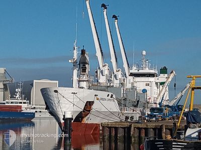
GREEN CRYSTAL
Reefer
Current Trip
CIABJ
| Time Travelled | 1 day |
|---|---|
| Remaining Time | --- |
| Distance Travelled | 3.21 nm |
| Remaining Distance | --- |
| AVG Speed | 6 Knots |
| MAX Speed | 10.1 Knots |
| AVG Wind | 12 knots |
| MAX Wind | 14 knots |
| MIN Temp | 27.8°C / 82.04°F |
| MAX Temp | 29.1°C / 84.38°F |
| Draught | 6.4 m |
| Position Received | 11 d ago |
Current Position
| Longitude | --- |
|---|---|
| Latitude | --- |
| Status | At anchor |
| Speed | 0.2 Knots |
| Course | 355° |
| Area | North Atlantic Ocean |
| Station | T-AIS |
| Position Received | 11 d ago |
Information
The current position of GREEN CRYSTAL is in North Atlantic Ocean with coordinates 5.22146° / -4.09229° as reported on 2025-03-17 05:52 by AIS to our vessel tracker app. The vessel's current speed is 0.2 Knots
The vessel GREEN CRYSTAL (IMO: 8920995, MMSI: 311009700) is a Reefer that was built in 1992 ( 33 years old ). It's sailing under the flag of [BS] Bahamas.
In this page you can find informations about the vessels current position, last detected port calls, and current voyage information. If the vessels is not in coverage by AIS you will find the latest position.
The current position of GREEN CRYSTAL is detected by our AIS receivers and we are not responsible for the reliability of the data. The last position was recorded while the vessel was in Coverage by the Ais receivers of our vessel tracking app.
The current draught of GREEN CRYSTAL as reported by AIS is 6.4 meters
Weather
| Temperature | 27.9°C / 82.22°F |
|---|---|
| Wind Speed | 11 knots |
| Direction | 226° SW |
| Pressure | 1007.9 hPa |
| Humidity | 82.8 % |
| Cloud Coverage | 67 % |
Featured Company
Last Port Calls
| Port | Arrival | Departure | Time In Port |
|---|---|---|---|
| 2025-03-25 18:18 | 2025-03-27 20:26 | 2 d | |
| 2025-03-10 11:36 | 2025-03-15 22:03 | 5 d | |
| 2025-02-21 15:58 | 2025-02-22 19:17 | 1 d | |
| 2025-01-25 16:30 | 2025-02-02 09:18 | 7 d | |
| 2025-01-18 13:21 | 2025-01-20 22:41 | 2 d | |
| 2025-01-14 21:43 | 2025-01-17 01:39 | 2 d |
Most Visited Ports (Last year)
| Port | Arrivals | |
|---|---|---|
| 7 | ||
| 4 | ||
| 3 | ||
| 2 | ||
| 2 | ||
| 1 |
Last Trips
| Origin | Departure | Destination | Arrival | Distance | |
|---|---|---|---|---|---|
| 2025-03-15 22:03 | 2025-03-25 18:18 | 338.37 nm | |||
| 2025-02-22 19:17 | 2025-03-10 11:36 | 2085.23 nm | |||
| 2025-02-02 10:18 | 2025-02-21 15:58 | 3211.78 nm | |||
| 2025-01-20 23:41 | 2025-01-25 17:30 | 1034.61 nm | |||
| 2025-01-17 01:39 | 2025-01-18 14:21 | 461.06 nm | |||
| 2024-12-30 19:13 | 2025-01-14 21:43 | 2092.12 nm |
Events
| Time | Event | Details | Position / Dest | Info |
|---|---|---|---|---|
| 2025-03-27 21:13 | STOP Moving | 2.93 nm, South East of TEMA |
5.60330 / .05569
CIABJ
|
Speed: 0.3 kn Course: 231° |
| 2025-03-27 20:26 | PORT DEPARTURE |
|
5.63041 / .02307
CIABJ
|
Speed: 6 kn Course: 72° |
| 2025-03-27 20:22 | START Moving |
5.62818 / .01670
[GH] TEMA
|
Speed: 6 kn Course: 72° |
|
| 2025-03-25 18:32 | STOP Moving |
5.63289 / .01302
[GH] TEMA
|
Speed: 0.2 kn Course: 321° |
|
| 2025-03-25 18:18 | PORT ARRIVAL |
|
5.62807 / .01803
[GH] TEMA
|
Speed: 4.4 kn Course: 250° |
| 2025-03-25 17:02 | START Moving | 6.09 nm, South East of TEMA |
5.54781 / .07505
CIABJ
|
Speed: 7.1 kn Course: 82° |
| 2025-03-25 15:58 | STOP Moving | 5.23 nm, South East of TEMA |
5.55699 / .06304
CIABJ
|
Speed: 0.3 kn Course: 236° |
| 2025-03-24 17:04 | START Moving | 6.97 nm, South West of ABIDJAN |
5.21933 / -4.09114
CIABJ
|
Speed: 7.5 kn Course: 178° |