
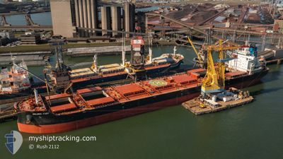
GOLDEN FAST
Cargo
Current Trip
| Time Travelled | 13 days |
|---|---|
| Remaining Time | --- |
| Distance Travelled | 4077.59 nm |
| Remaining Distance | --- |
| AVG Speed | 12.2 Knots |
| MAX Speed | 15.3 Knots |
| AVG Wind | 11.7 knots |
| MAX Wind | 23.9 knots |
| MIN Temp | 17.2°C / 62.96°F |
| MAX Temp | 25.6°C / 78.08°F |
| Draught | 7 m |
| Position Received | 2 m ago |
Current Position
| Longitude | -76.40728° |
|---|---|
| Latitude | 38.91687° |
| Status | At anchor |
| Speed | 0.2 Knots |
| Course | 285° |
| Area | North Atlantic Ocean |
| Station | T-AIS |
| Position Received | 2 m ago |
Info
Information
The current position of GOLDEN FAST is in North Atlantic Ocean with coordinates 38.91687° / -76.40728° as reported on 2024-06-10 16:04 by AIS to our vessel tracker app. The vessel's current speed is 0.2 Knots
The vessel GOLDEN FAST (MMSI: 538009293) is a Cargo It's sailing under the flag of [MH] Marshall Is.
In this page you can find informations about the vessels current position, last detected port calls, and current voyage information. If the vessels is not in coverage by AIS you will find the latest position.
The current position of GOLDEN FAST is detected by our AIS receivers and we are not responsible for the reliability of the data. The last position was recorded while the vessel was in Coverage by the Ais receivers of our vessel tracking app.
The current draught of GOLDEN FAST as reported by AIS is 7 meters
Weather
| Temperature | 22.7°C / 72.86°F |
|---|---|
| Wind Speed | 9 knots |
| Direction | 308° NW |
| Pressure | 1006.6 hPa |
| Humidity | 46.6 % |
| Cloud Coverage | 3 % |
Featured Company
Most Visited Ports (Last year)
| Port | Arrivals | |
|---|---|---|
| 2 | ||
| 2 | ||
| 1 | ||
| 1 | ||
| 1 | ||
| 1 |
Events
| Time | Event | Details | Position / Dest | Info |
|---|---|---|---|---|
| 2024-06-10 14:48 | Status Changed | At anchor Default |
38.91911 / -76.40815
USBAL
|
Speed: 0.1 kn Course: 222° |
| 2024-06-10 14:45 | Status Changed | Default At anchor |
38.91909 / -76.40835
USBAL
|
Speed: 0.9 kn Course: 234° |
| 2024-06-10 14:38 | Status Changed | At anchor Under way using engine |
38.91812 / -76.40903
USBAL
|
Speed: 0.7 kn Course: 238° |
| 2024-06-10 14:26 | Status Changed | Under way using engine At anchor |
38.91788 / -76.40915
USBAL
|
Speed: 0.8 kn Course: 233° |
| 2024-06-10 14:25 | Status Changed | At anchor Under way using engine |
38.91816 / -76.40900
USBAL
|
Speed: 1 kn Course: 240° |
| 2024-06-10 14:23 | STOP Moving | 11.88 nm, North West of SAINT MICHAELS |
38.91790 / -76.40918
USBAL
|
Speed: 0.2 kn Course: 239° |
| 2024-06-10 12:23 | Draught Changed | 7 7.1 |
38.51109 / -76.40878
USBAL
|
Speed: 13.7 kn Course: 336.6° |
| 2024-06-10 12:16 | Status Changed | Under way using engine Default |
38.48646 / -76.39517
USBAL
|
Speed: 13.8 kn Course: 336° |
| 2024-06-10 12:15 | Status Changed | Default Under way using engine |
38.48476 / -76.39423
USBAL
|
Speed: 13.8 kn Course: 336.4° |
| 2024-06-10 10:00 | ETA Changed | 2024/06/10 14:30 2024/06/10 05:30 |
37.97373 / -76.19366
USBAL
|
Speed: 14.1 kn Course: 344.8° |