
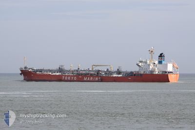
GINGA PANTHER
Oil/Chemical Tanker
Current Trip
| Trip Time | 10 days |
|---|---|
| Trip Distance | 1085.21 nm |
| AVG Speed | 9.5 Knots |
| MAX Speed | 14.7 Knots |
| Draught | 10.1 m |
| AVG Wind | 11.7 knots |
| MAX Wind | 21 knots |
| MIN Temp | -2.4°C / 27.68°F |
| MAX Temp | 13.1°C / 55.58°F |
| Position Received | 2025-12-02 02:06 |
Current Position
| Longitude | --- |
|---|---|
| Latitude | --- |
| Status | Under way using engine |
| Speed | 12.1 Knots |
| Course | 271.8° |
| Area | North Pacific Ocean |
| Station | T-AIS |
| Position Received | 2025-12-02 02:06 |
Info
Information
The current position of GINGA PANTHER is in North Pacific Ocean with coordinates 48.52602° / -126.79897° as reported on 2025-12-02 02:06 by AIS to our vessel tracker app. The vessel's current speed is 12.1 Knots and is currently inside the port of ULSAN.
The vessel GINGA PANTHER (IMO: 9379985, MMSI: 372792000) is a Oil/Chemical Tanker that was built in 2007 ( 19 years old ). It's sailing under the flag of [PA] Panama.
In this page you can find informations about the vessels current position, last detected port calls, and current voyage information. If the vessels is not in coverage by AIS you will find the latest position.
The current position of GINGA PANTHER is detected by our AIS receivers and we are not responsible for the reliability of the data. The last position was recorded while the vessel was in Coverage by the Ais receivers of our vessel tracking app.
The current draught of GINGA PANTHER as reported by AIS is 10.1 meters
Weather
| Temperature | 2.8°C / 37.04°F |
|---|---|
| Wind Speed | 11 knots |
| Direction | 315° NW |
| Pressure | 1021 hPa |
| Humidity | 37.8 % |
| Cloud Coverage | 34 % |
Featured Company
Last Trips
| Origin | Departure | Destination | Arrival | Distance | |
|---|---|---|---|---|---|
| 2025-12-25 13:31 | 2026-01-05 11:17 | 1085.21 nm | |||
| 2025-11-30 21:35 | 2025-12-24 18:50 | 6088.66 nm | |||
| 2025-11-26 17:18 | 2025-11-28 22:50 | 12.26 nm | |||
| 2025-11-17 15:22 | 2025-11-26 04:27 | 2475.65 nm | |||
| 2025-10-24 16:43 | 2025-11-15 16:34 | 6658.06 nm |
Events
| Time | Event | Details | Position / Dest | Info |
|---|---|---|---|---|
| 2026-01-05 02:17 | STOP Moving |
35.51767 / 129.39386
[KR] ULSAN
|
Speed: Course: 337° |
|
| 2026-01-05 02:17 | PORT ARRIVAL |
|
35.51767 / 129.39386
[KR] ULSAN
|
Speed: 0.6 kn Course: 349° |
| 2026-01-02 00:53 | START Moving | 3.29 nm, East of CHANGZHOU |
31.95587 / 120.07965
JIYAGNYIN
|
Speed: 6.2 kn Course: 178° |
| 2026-01-01 11:57 | STOP Moving | 3.42 nm, East of CHANGZHOU |
31.95844 / 120.08276
JIYAGNYIN
|
Speed: 0.2 kn Course: 287° |
| 2026-01-01 11:24 | START Moving | 3.85 nm, West of JIANGYIN |
31.94198 / 120.10272
JIYAGNYIN
|
Speed: 4 kn Course: 299° |
| 2025-12-30 11:19 | STOP Moving | 3.62 nm, West of JIANGYIN |
31.93912 / 120.10651
JIYAGNYIN
|
Speed: Course: 291° |
| 2025-12-29 20:16 | START Moving |
31.13553 / 122.60348
JIYAGNYIN
|
Speed: 3.1 kn Course: 270° |
|
| 2025-12-27 20:00 | STOP Moving |
31.13730 / 122.60616
JIYAGNYIN
|
Speed: 0.3 kn Course: 163° |
|
| 2025-12-26 22:40 | START Moving | 1.6 nm, East of ZHANGJIAGANG |
31.97649 / 120.44339
JIYAGNYIN
|
Speed: 3.2 kn Course: 48° |