
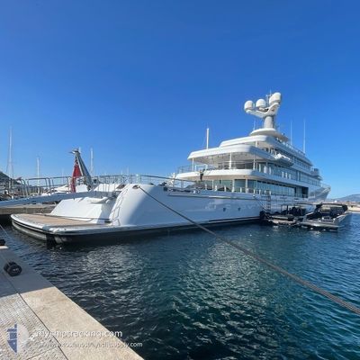
FOUNTAINHEAD
Yacht
Current Trip
| Trip Time | 2 days |
|---|---|
| Trip Distance | 770.95 nm |
| AVG Speed | 15 Knots |
| MAX Speed | 19.5 Knots |
| Draught | 4.2 m |
| AVG Wind | 18.5 knots |
| MAX Wind | 33 knots |
| MIN Temp | 12.7°C / 54.86°F |
| MAX Temp | 17.6°C / 63.68°F |
| Position Received | 1 m ago |
Current Position
| Longitude | 7.12965° |
|---|---|
| Latitude | 43.58612° |
| Status | Moored |
| Speed | |
| Course | 306° |
| Area | Mediterranean Sea - Western Basin |
| Station | T-AIS |
| Position Received | 1 m ago |
Info
Information
The current position of FOUNTAINHEAD is in Mediterranean Sea - Western Basin with coordinates 43.58612° / 7.12965° as reported on 2024-05-10 18:49 by AIS to our vessel tracker app. The vessel's current speed is 0 Knots and is currently inside the port of ANTIBES.
The vessel FOUNTAINHEAD (IMO: 1010753, MMSI: 319028100) is a Yacht that was built in 2011 ( 13 years old ). It's sailing under the flag of [KY] Cayman Is.
In this page you can find informations about the vessels current position, last detected port calls, and current voyage information. If the vessels is not in coverage by AIS you will find the latest position.
The current position of FOUNTAINHEAD is detected by our AIS receivers and we are not responsible for the reliability of the data. The last position was recorded while the vessel was in Coverage by the Ais receivers of our vessel tracking app.
The current draught of FOUNTAINHEAD as reported by AIS is 4.2 meters
Weather
| Temperature | 18.9°C / 66.02°F |
|---|---|
| Wind Speed | 9 knots |
| Direction | 251° WSW |
| Pressure | 1017.2 hPa |
| Humidity | 68.8 % |
| Cloud Coverage | 3 % |
Featured Company
Most Visited Ports (Last year)
| Port | Arrivals | |
|---|---|---|
| 6 | ||
| 3 | ||
| 2 | ||
| 1 | ||
| 1 | ||
| 1 |
Events
| Time | Event | Details | Position / Dest | Info |
|---|---|---|---|---|
| 2024-05-02 20:00 | Status Changed | Moored Under way using engine |
43.58612 / 7.12965
[FR] ANTIBES
|
Speed: Course: 306° |
| 2024-05-02 19:22 | STOP Moving |
43.58671 / 7.12837
[FR] ANTIBES
|
Speed: 0.3 kn Course: 293° |
|
| 2024-05-02 19:12 | PORT ARRIVAL |
|
43.59064 / 7.13141
[FR] ANTIBES
|
Speed: 4 kn Course: 197° |
| 2024-05-02 15:58 | Change Sea Area | French part of the Mediterranean Sea - Western Basin Spanish part of the Mediterranean Sea - Western Basin |
42.96332 / 6.55629
Mediterranean Sea - Western Basin
FR ANT
|
Speed: 13.9 kn Course: 37.9° |
| 2024-05-02 15:58 | IN Coverage |
42.96332 / 6.55629
Mediterranean Sea - Western Basin
FR ANT
|
Speed: 13.9 kn Course: 37.9° |
|
| 2024-05-01 13:32 | OUT of Coverage |
38.55267 / .35376
Mediterranean Sea - Western Basin
FR ANT
|
Speed: 16.6 kn Course: 30.6° |
|
| 2024-05-01 13:12 | IN Coverage |
38.48446 / .29597
Mediterranean Sea - Western Basin
FR ANT
|
Speed: 16.8 kn Course: 36° |
|
| 2024-05-01 09:49 | OUT of Coverage |
37.69989 / -.38561
Mediterranean Sea - Western Basin
FR ANT
|
Speed: 17.5 kn Course: 31.3° |
|
| 2024-05-01 03:47 | Detected in Sea | Spanish part of the Mediterranean Sea - Western Basin |
36.61492 / -1.82391
Mediterranean Sea - Western Basin
FR ANT
|
Speed: 15.6 kn Course: 49.3° |
| 2024-05-01 03:47 | IN Coverage |
36.61492 / -1.82391
Mediterranean Sea - Western Basin
FR ANT
|
Speed: 15.6 kn Course: 49.3° |