
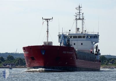
FEED TRONDHEIM
General Cargo
Current Trip
| Time Travelled | 22 h, 22 mins |
|---|---|
| Remaining Time | 1 day |
| Distance Travelled | 219.44 nm |
| Remaining Distance | 473.63 nm |
| AVG Speed | 10 Knots |
| MAX Speed | 11.2 Knots |
| AVG Wind | 12.1 knots |
| MAX Wind | 14.1 knots |
| MIN Temp | 7.1°C / 44.78°F |
| MAX Temp | 9.1°C / 48.38°F |
| Draught | 5.7 m |
| Position Received | 1 m ago |
Current Position
| Longitude | 14.67050° |
|---|---|
| Latitude | 55.43850° |
| Status | Under way using engine |
| Speed | 10 Knots |
| Course | 259° |
| Area | Kattegat |
| Station | T-AIS |
| Position Received | 1 m ago |
Info
Information
The current position of FEED TRONDHEIM is in Kattegat with coordinates 55.43850° / 14.67050° as reported on 2024-04-28 12:44 by AIS to our vessel tracker app. The vessel's current speed is 10 Knots and is heading at the port of FISKA. The estimated time of arrival as calculated by MyShipTracking vessel tracking app is 2024-04-30 11:48 LT
The vessel FEED TRONDHEIM (IMO: 9226798, MMSI: 305371000) is a General Cargo that was built in 2002 ( 22 years old ). It's sailing under the flag of [AG] Antigua Barbuda.
In this page you can find informations about the vessels current position, last detected port calls, and current voyage information. If the vessels is not in coverage by AIS you will find the latest position.
The current position of FEED TRONDHEIM is detected by our AIS receivers and we are not responsible for the reliability of the data. The last position was recorded while the vessel was in Coverage by the Ais receivers of our vessel tracking app.
The current draught of FEED TRONDHEIM as reported by AIS is 5.7 meters
Weather
| Temperature | 8.8°C / 47.84°F |
|---|---|
| Wind Speed | 13 knots |
| Direction | 128° SE |
| Pressure | 1015.6 hPa |
| Humidity | 83.8 % |
| Cloud Coverage | 58 % |
Featured Company
Last Port Calls
| Port | Arrival | Departure | Time In Port |
|---|---|---|---|
| 2024-04-27 01:22 | 2024-04-27 14:23 | 13 h | |
| 2024-04-25 07:01 | 2024-04-25 23:46 | 16 h | |
| 2024-04-23 03:28 | 2024-04-24 00:00 | 20 h | |
| 2024-04-20 10:49 | 2024-04-21 00:32 | 13 h | |
| 2024-04-18 04:48 | 2024-04-18 17:12 | 12 h | |
| 2024-04-15 02:32 | 2024-04-16 11:25 | 1 d | |
| 2024-04-08 21:53 | 2024-04-09 23:16 | 1 d | |
| 2024-04-06 16:25 | 2024-04-08 15:10 | 1 d | |
| 2024-03-31 10:42 | 2024-04-01 14:09 | 1 d | |
| 2024-03-30 06:51 | 2024-03-31 05:19 | 22 h |
Most Visited Ports (Last year)
| Port | Arrivals | |
|---|---|---|
| 9 | ||
| 7 | ||
| 6 | ||
| 6 | ||
| 5 | ||
| 5 |
Last Trips
| Origin | Departure | Destination | Arrival | Distance | |
|---|---|---|---|---|---|
| 2024-04-26 01:46 | 2024-04-27 04:22 | 267.73 nm | |||
| 2024-04-24 03:00 | 2024-04-25 09:01 | 220.56 nm | |||
| 2024-04-21 02:32 | 2024-04-23 06:28 | 463.92 nm | |||
| 2024-04-18 19:12 | 2024-04-20 12:49 | 341.94 nm | |||
| 2024-04-16 13:25 | 2024-04-18 06:48 | 418.42 nm | |||
| 2024-04-10 01:16 | 2024-04-15 04:32 | 901.80 nm | |||
| 2024-04-08 17:10 | 2024-04-08 23:53 | 75.61 nm | |||
| 2024-04-01 17:09 | 2024-04-06 18:25 | 968.40 nm | |||
| 2024-03-31 08:19 | 2024-03-31 13:42 | 56.60 nm | |||
| 2024-03-26 05:47 | 2024-03-30 08:51 | 780.34 nm |
Events
| Time | Event | Details | Position / Dest | Info |
|---|---|---|---|---|
| 2024-04-28 08:49 | Change Sea Area | Danish part of the Kattegat Swedish part of the Baltic Sea |
55.51600 / 15.80233
Kattegat
FISKAA
|
Speed: 9.7 kn Course: 263° |
| 2024-04-28 05:43 | Status Changed | Under way using engine Default |
55.58014 / 16.68226
FISKAA
|
Speed: 10.4 kn Course: 258° |
| 2024-04-28 05:28 | IN Coverage |
55.58014 / 16.68226
Baltic Sea
FISKAA
|
Speed: 10.5 kn Course: 252.7° |
|
| 2024-04-28 02:56 | Status Changed | Default Under way using engine |
55.63484 / 17.47075
FISKAA
|
Speed: 10 kn Course: 261° |
| 2024-04-28 02:49 | Change Sea Area | Swedish part of the Baltic Sea Polish part of the Baltic Sea |
55.63698 / 17.50122
Baltic Sea
FISKAA
|
Speed: 10 kn Course: 261° |
| 2024-04-28 02:49 | Status Changed | Under way using engine Default |
55.63698 / 17.50122
FISKAA
|
Speed: 8 kn Course: 288° |
| 2024-04-28 02:49 | OUT of Coverage |
55.63698 / 17.50122
Baltic Sea
FISKAA
|
Speed: 10 kn Course: 261° |
|
| 2024-04-28 02:20 | Status Changed | Default Under way using engine |
55.62921 / 17.63791
FISKAA
|
Speed: 9.5 kn Course: 278.1° |
| 2024-04-28 02:13 | Status Changed | Under way using engine Default |
55.62636 / 17.67000
FISKAA
|
Speed: 9 kn Course: 278° |
| 2024-04-28 02:08 | Status Changed | Default Under way using engine |
55.62404 / 17.69491
FISKAA
|
Speed: 8.8 kn Course: 279° |