
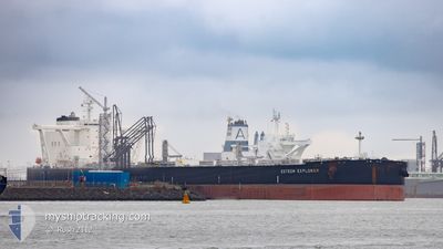
ESTEEM EXPLORER
Tanker
Current Trip
| Time Travelled | 14 days |
|---|---|
| Remaining Time | --- |
| Distance Travelled | 3440.12 nm |
| Remaining Distance | --- |
| AVG Speed | 9.7 Knots |
| MAX Speed | 14.7 Knots |
| AVG Wind | 14.8 knots |
| MAX Wind | 29.9 knots |
| MIN Temp | 6.8°C / 44.24°F |
| MAX Temp | 23.1°C / 73.58°F |
| Draught | 11 m |
| Position Received | 1 d ago |
Current Position
| Longitude | -57.50177° |
|---|---|
| Latitude | 29.81686° |
| Status | Under way using engine |
| Speed | 10 Knots |
| Course | 257.7° |
| Area | North Atlantic Ocean |
| Station | T-AIS |
| Position Received | 1 d ago |
Info
Information
The current position of ESTEEM EXPLORER is in North Atlantic Ocean with coordinates 29.81686° / -57.50177° as reported on 2024-05-11 05:15 by AIS to our vessel tracker app. The vessel's current speed is 10 Knots and is heading at the port of CORPUS CHRISTI. The estimated time of arrival as calculated by MyShipTracking vessel tracking app is 2024-05-21 14:00 LT
The vessel ESTEEM EXPLORER (IMO: 9855484, MMSI: 355051000) is a Tanker It's sailing under the flag of [PA] Panama.
In this page you can find informations about the vessels current position, last detected port calls, and current voyage information. If the vessels is not in coverage by AIS you will find the latest position.
The current position of ESTEEM EXPLORER is detected by our AIS receivers and we are not responsible for the reliability of the data. The last position was recorded while the vessel was in Coverage by the Ais receivers of our vessel tracking app.
The current draught of ESTEEM EXPLORER as reported by AIS is 11 meters
Weather
| Temperature | 22.6°C / 72.68°F |
|---|---|
| Wind Speed | 16 knots |
| Direction | 198° SSW |
| Pressure | 1013.7 hPa |
| Humidity | 81.1 % |
| Cloud Coverage | 48 % |
Featured Company
Last Port Calls
| Port | Arrival | Departure | Time In Port |
|---|---|---|---|
| 2024-04-26 13:15 | 2024-04-27 14:57 | 1 d | |
| 2024-04-24 01:42 | 2024-04-26 12:51 | 2 d | |
| 2024-03-31 18:26 | 2024-04-02 14:19 | 1 d |
Most Visited Ports (Last year)
| Port | Arrivals | |
|---|---|---|
| 2 | ||
| 2 | ||
| 1 | ||
| 1 |
Last Trips
| Origin | Departure | Destination | Arrival | Distance | |
|---|---|---|---|---|---|
| 2024-04-26 14:51 | 2024-04-26 15:15 | 1.95 nm | |||
| 2024-04-02 09:19 | 2024-04-24 03:42 | 5766.22 nm | |||
| 2024-02-25 02:16 | 2024-03-31 13:26 | 5889.77 nm |
Events
| Time | Event | Details | Position / Dest | Info |
|---|---|---|---|---|
| 2024-05-11 05:20 | Status Changed | Default Under way using engine |
29.81397 / -57.51876
USCRP
|
Speed: 10 kn Course: 257.7° |
| 2024-05-11 05:15 | OUT of Coverage |
29.81686 / -57.50177
North Atlantic Ocean
USCRP
|
Speed: 10 kn Course: 257.7° |
|
| 2024-05-11 01:51 | Change Sea Area | High seas of the North Atlantic Ocean Portuguese (Azores) part of the North Atlantic Ocean |
29.93733 / -56.87376
North Atlantic Ocean
USCRP
|
Speed: 9.6 kn Course: 255.2° |
| 2024-05-11 01:51 | Status Changed | Under way using engine Default |
29.93733 / -56.87376
USCRP
|
Speed: 9.5 kn Course: 259° |
| 2024-05-11 01:37 | IN Coverage |
29.93733 / -56.87376
North Atlantic Ocean
USCRP
|
Speed: 9.6 kn Course: 255.2° |
|
| 2024-05-04 21:17 | Status Changed | Default Under way using engine |
36.96600 / -29.98498
USCRP
|
Speed: 8.5 kn Course: 249.7° |
| 2024-05-04 21:13 | OUT of Coverage |
36.96959 / -29.97260
North Atlantic Ocean
USCRP
|
Speed: 8.5 kn Course: 249.7° |
|
| 2024-05-04 18:15 | Status Changed | Under way using engine Default |
37.12588 / -29.46473
USCRP
|
Speed: 8.6 kn Course: 250° |
| 2024-05-04 18:12 | Status Changed | Default Under way using engine |
37.12801 / -29.45772
USCRP
|
Speed: 8.6 kn Course: 249.5° |
| 2024-05-04 05:40 | Status Changed | Under way using engine Default |
37.86409 / -27.07459
USCRP
|
Speed: 7.9 kn Course: 251° |