
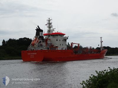
ELSA ESSBERGER
Oil/Chemical Tanker
Current Trip
| Time Travelled | 14 h, 44 mins |
|---|---|
| Remaining Time | 7 h, 11 mins |
| Distance Travelled | 177.12 nm |
| Remaining Distance | 83.43 nm |
| AVG Speed | 13 Knots |
| MAX Speed | 15.7 Knots |
| AVG Wind | 9.9 knots |
| MAX Wind | 14.7 knots |
| MIN Temp | 4.7°C / 40.46°F |
| MAX Temp | 7.1°C / 44.78°F |
| Draught | 5.9 m |
| Position Received | 2 m ago |
Current Position
| Longitude | --- |
|---|---|
| Latitude | --- |
| Status | Under way using engine |
| Speed | 11.2 Knots |
| Course | 237.9° |
| Area | English Channel |
| Station | T-AIS |
| Position Received | 2 m ago |
Info
Information
The current position of ELSA ESSBERGER is in English Channel with coordinates 50.58951° / 0.64987° as reported on 2025-03-01 11:49 by AIS to our vessel tracker app. The vessel's current speed is 11.2 Knots and is heading at the port of LE HAVRE. The estimated time of arrival as calculated by MyShipTracking vessel tracking app is 2025-03-01 20:03 LT
The vessel ELSA ESSBERGER (IMO: 9481001, MMSI: 255805470) is a Oil/Chemical Tanker that was built in 2013 ( 12 years old ). It's sailing under the flag of [PT] Portugal.
In this page you can find informations about the vessels current position, last detected port calls, and current voyage information. If the vessels is not in coverage by AIS you will find the latest position.
The current position of ELSA ESSBERGER is detected by our AIS receivers and we are not responsible for the reliability of the data. The last position was recorded while the vessel was in Coverage by the Ais receivers of our vessel tracking app.
The current draught of ELSA ESSBERGER as reported by AIS is 5.9 meters
Weather
| Temperature | 7°C / 44.6°F |
|---|---|
| Wind Speed | 14 knots |
| Direction | 51° NE |
| Pressure | 1033.9 hPa |
| Humidity | 71.8 % |
| Cloud Coverage | 6 % |
Featured Company
Last Port Calls
| Port | Arrival | Departure | Time In Port |
|---|---|---|---|
| 2025-02-27 17:47 | 2025-02-28 22:08 | 1 d | |
| 2025-02-22 07:26 | 2025-02-23 06:00 | 22 h | |
| 2025-02-20 04:35 | 2025-02-21 02:07 | 21 h | |
| 2025-02-14 20:40 | 2025-02-18 13:35 | 3 d | |
| 2025-02-06 17:38 | 2025-02-11 20:09 | 5 d | |
| 2025-02-04 16:31 | 2025-02-05 11:42 | 19 h | |
| 2025-01-31 14:27 | 2025-02-01 14:47 | 1 d | |
| 2025-01-21 18:52 | 2025-01-30 02:32 | 8 d | |
| 2025-01-17 12:11 | 2025-01-17 13:23 | 1 h | |
| 2025-01-16 17:24 | 2025-01-16 18:59 | 1 h |
Most Visited Ports (Last year)
| Port | Arrivals | |
|---|---|---|
| 28 | ||
| 21 | ||
| 10 | ||
| 3 | ||
| 2 | ||
| 2 |
Last Trips
| Origin | Departure | Destination | Arrival | Distance | |
|---|---|---|---|---|---|
| 2025-02-23 06:00 | 2025-02-27 17:47 | 265.56 nm | |||
| 2025-02-21 02:07 | 2025-02-22 07:26 | 262.37 nm | |||
| 2025-02-18 13:35 | 2025-02-20 04:35 | 250.42 nm | |||
| 2025-02-11 20:09 | 2025-02-14 20:40 | 267.80 nm | |||
| 2025-02-05 11:42 | 2025-02-06 17:38 | 254.08 nm | |||
| 2025-02-01 14:47 | 2025-02-04 16:31 | 267.45 nm | |||
| 2025-01-30 02:32 | 2025-01-31 14:27 | 261.03 nm | |||
| 2025-01-17 13:23 | 2025-01-21 18:52 | 18.67 nm | |||
| 2025-01-16 18:59 | 2025-01-17 12:11 | 0.57 nm | |||
| 2025-01-15 11:25 | 2025-01-16 17:24 | 355.22 nm |
Events
| Time | Event | Details | Position / Dest | Info |
|---|---|---|---|---|
| 2025-03-01 11:50 | Status Changed | Default Under way using engine |
50.58918 / .64894
NLRTM>FRLEH
|
Speed: 11.2 kn Course: 237.9° |
| 2025-03-01 11:36 | Status Changed | Under way using engine Default |
50.61257 / .70297
NLRTM>FRLEH
|
Speed: 11.1 kn Course: 233° |
| 2025-03-01 11:30 | Status Changed | Default Under way using engine |
50.62436 / .72812
NLRTM>FRLEH
|
Speed: 11.1 kn Course: 232.4° |
| 2025-03-01 08:20 | Change Sea Area | United Kingdom part of the English Channel United Kingdom part of the North Sea |
51.07655 / 1.45095
English Channel
NLRTM>FRLEH
|
Speed: 15.3 kn Course: 231.8° |
| 2025-03-01 04:02 | Status Changed | Under way using engine Default |
51.76197 / 2.37963
NLRTM>FRLEH
|
Speed: 10.6 kn Course: 221° |
| 2025-03-01 03:58 | Status Changed | Default Under way using engine |
51.77267 / 2.39474
NLRTM>FRLEH
|
Speed: 10.6 kn Course: 221.7° |
| 2025-03-01 03:52 | Status Changed | Under way using engine Default |
51.78430 / 2.41161
NLRTM>FRLEH
|
Speed: 10.6 kn Course: 223° |
| 2025-03-01 03:49 | Status Changed | Default Under way using engine |
51.79050 / 2.42055
NLRTM>FRLEH
|
Speed: 10.5 kn Course: 221.6° |
| 2025-03-01 03:43 | Detected in Sea | United Kingdom part of the North Sea |
51.80354 / 2.43938
North Sea
NLRTM>FRLEH
|
Speed: 10.5 kn Course: 221.6° |
| 2025-03-01 03:43 | Status Changed | Under way using engine Default |
51.80354 / 2.43938
NLRTM>FRLEH
|
Speed: 10.5 kn Course: 223° |