
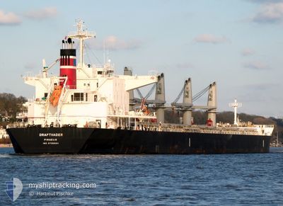
DRAFTVADER
Cargo
Current Trip
| Time Travelled | 8 days |
|---|---|
| Remaining Time | --- |
| Distance Travelled | 2003.73 nm |
| Remaining Distance | --- |
| AVG Speed | 10.1 Knots |
| MAX Speed | 13.1 Knots |
| AVG Wind | 10.6 knots |
| MAX Wind | 25.9 knots |
| MIN Temp | 8.2°C / 46.76°F |
| MAX Temp | 16.6°C / 61.88°F |
| Draught | 9.1 m |
| Position Received | 9 h, 34 m ago |
Current Position
| Longitude | --- |
|---|---|
| Latitude | --- |
| Status | Under way using engine |
| Speed | 12.6 Knots |
| Course | 240.8° |
| Area | North Atlantic Ocean |
| Station | T-AIS |
| Position Received | 9 h, 34 m ago |
Info
Information
The current position of DRAFTVADER is in North Atlantic Ocean with coordinates 35.94281° / -6.22158° as reported on 2026-02-28 07:30 by AIS to our vessel tracker app. The vessel's current speed is 12.6 Knots and is heading at the port of BUENOS AIRES. The estimated time of arrival as calculated by MyShipTracking vessel tracking app is 2026-03-17 09:00 LT
The vessel DRAFTVADER (IMO: 9736664, MMSI: 241375000) is a Cargo It's sailing under the flag of [GR] Greece.
In this page you can find informations about the vessels current position, last detected port calls, and current voyage information. If the vessels is not in coverage by AIS you will find the latest position.
The current position of DRAFTVADER is detected by our AIS receivers and we are not responsible for the reliability of the data. The last position was recorded while the vessel was in Coverage by the Ais receivers of our vessel tracking app.
The current draught of DRAFTVADER as reported by AIS is 9.1 meters
Weather
| Temperature | 14.8°C / 58.64°F |
|---|---|
| Wind Speed | 15 knots |
| Direction | 12° NNE |
| Pressure | 1019.8 hPa |
| Humidity | 81.2 % |
| Cloud Coverage | 60 % |
Featured Company
Last Port Calls
| Port | Arrival | Departure | Time In Port |
|---|---|---|---|
| 2026-02-14 22:17 | 2026-02-20 15:37 | 5 d | |
| 2026-01-02 11:38 | 2026-01-06 18:58 | 4 d |
Last Trips
| Origin | Departure | Destination | Arrival | Distance | |
|---|---|---|---|---|---|
| 2026-01-06 18:58 | 2026-02-14 22:17 | 7270.98 nm | |||
| 2025-11-22 18:10 | 2026-01-02 11:38 | 6781.10 nm |
Events
| Time | Event | Details | Position / Dest | Info |
|---|---|---|---|---|
| 2026-02-28 07:32 | Status Changed | Default Under way using engine |
35.93815 / -6.23170
RECALADA
|
Speed: 12.6 kn Course: 240.8° |
| 2026-02-28 07:30 | OUT of Coverage |
35.94281 / -6.22158
North Atlantic Ocean
RECALADA
|
Speed: 12.6 kn Course: 240.8° |
|
| 2026-02-28 07:23 | Change Sea Area | Spanish part of the North Atlantic Ocean Moroccan part of the North Atlantic Ocean |
35.95360 / -6.19581
North Atlantic Ocean
RECALADA
|
Speed: 12.5 kn Course: 256.1° |
| 2026-02-28 07:21 | Status Changed | Under way using engine Default |
35.95444 / -6.18944
RECALADA
|
Speed: 12.8 kn Course: 270° |
| 2026-02-28 06:39 | Status Changed | Default Under way using engine |
35.95699 / -6.00692
RECALADA
|
Speed: 12.7 kn Course: 269.2° |
| 2026-02-28 06:33 | Detected in Sea | Moroccan part of the North Atlantic Ocean |
35.95720 / -5.98001
North Atlantic Ocean
RECALADA
|
Speed: 12.7 kn Course: 269.2° |
| 2026-02-28 06:33 | Status Changed | Under way using engine Default |
35.95720 / -5.98001
RECALADA
|
Speed: 12.7 kn Course: 269° |
| 2026-02-28 06:31 | Status Changed | Default Under way using engine |
35.95731 / -5.97062
RECALADA
|
Speed: 12.5 kn Course: 269.9° |
| 2026-02-28 06:10 | Status Changed | Under way using engine Default |
35.95775 / -5.88375
RECALADA
|
Speed: 12.3 kn Course: 270° |
| 2026-02-28 06:04 | Status Changed | Default Under way using engine |
35.95774 / -5.85835
RECALADA
|
Speed: 12.4 kn Course: 270.1° |