
DEO JUVANTE
Cargo
Current Trip
| Time Travelled | 1 day |
|---|---|
| Remaining Time | 2 h, 45 mins |
| Distance Travelled | 107.44 nm |
| Remaining Distance | 18.09 nm |
| AVG Speed | 6.4 Knots |
| MAX Speed | 10.8 Knots |
| AVG Wind | 4.7 knots |
| MAX Wind | 9 knots |
| MIN Temp | 14.2°C / 57.56°F |
| MAX Temp | 23.9°C / 75.02°F |
| Draught | 3 m |
| Position Received | Now |
Current Position
| Longitude | 6.74449° |
|---|---|
| Latitude | 51.40262° |
| Status | Under way using engine |
| Speed | 5.6 Knots |
| Course | 177.7° |
| Area | North Sea |
| Station | T-AIS |
| Position Received | Now |
Info
Information
The current position of DEO JUVANTE is in North Sea with coordinates 51.40262° / 6.74449° as reported on 2024-05-01 09:53 by AIS to our vessel tracker app. The vessel's current speed is 5.6 Knots and is heading at the port of NEUSS. The estimated time of arrival as calculated by MyShipTracking vessel tracking app is 2024-05-01 12:38 LT
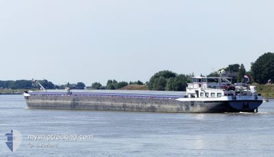
The vessel DEO JUVANTE (MMSI: 244660319) is a Cargo It's sailing under the flag of [NL] Netherlands.
In this page you can find informations about the vessels current position, last detected port calls, and current voyage information. If the vessels is not in coverage by AIS you will find the latest position.
The current position of DEO JUVANTE is detected by our AIS receivers and we are not responsible for the reliability of the data. The last position was recorded while the vessel was in Coverage by the Ais receivers of our vessel tracking app.
The current draught of DEO JUVANTE as reported by AIS is 3 meters
Weather
| Temperature | 22.2°C / 71.96°F |
|---|---|
| Wind Speed | 2 knots |
| Direction | 54° NE |
| Pressure | 1006.5 hPa |
| Humidity | 64.8 % |
| Cloud Coverage | 42 % |
Featured Company
Last Port Calls
| Port | Arrival | Departure | Time In Port |
|---|---|---|---|
| 2024-04-29 14:42 | 2024-04-30 09:43 | 19 h | |
| 2024-04-29 11:25 | 2024-04-29 14:27 | 3 h | |
| 2024-04-27 22:44 | 2024-04-29 04:17 | 1 d | |
| 2024-04-26 05:11 | 2024-04-27 11:27 | 1 d | |
| 2024-04-25 23:47 | 2024-04-25 23:58 | 10 m | |
| 2024-04-25 09:15 | 2024-04-25 09:50 | 34 m | |
| 2024-04-24 15:51 | 2024-04-24 21:42 | 5 h | |
| 2024-04-24 15:24 | 2024-04-24 15:42 | 17 m | |
| 2024-04-23 11:13 | 2024-04-24 14:35 | 1 d | |
| 2024-04-23 08:30 | 2024-04-23 10:03 | 1 h |
Last Trips
| Origin | Departure | Destination | Arrival | Distance | |
|---|---|---|---|---|---|
| 2024-04-29 16:27 | 2024-04-29 16:42 | 1.20 nm | |||
| 2024-04-29 06:17 | 2024-04-29 13:25 | 49.76 nm | |||
| 2024-04-27 13:27 | 2024-04-28 00:44 | 85.19 nm | |||
| 2024-04-26 01:58 | 2024-04-26 07:11 | 26.85 nm | |||
| 2024-04-25 11:50 | 2024-04-26 01:47 | 81.65 nm | |||
| 2024-04-24 23:42 | 2024-04-25 11:15 | 63.92 nm | |||
| 2024-04-24 17:42 | 2024-04-24 17:51 | 0.95 nm | |||
| 2024-04-24 16:35 | 2024-04-24 17:24 | 4.60 nm | |||
| 2024-04-23 12:03 | 2024-04-23 13:13 | 8.36 nm | |||
| 2024-04-23 08:07 | 2024-04-23 10:30 | 22.65 nm |
Events
| Time | Event | Details | Position / Dest | Info |
|---|---|---|---|---|
| 2024-05-01 07:06 | IN Coverage |
51.56703 / 6.62467
North Sea
|
Speed: 6 kn Course: 69.8° |
|
| 2024-05-01 02:59 | OUT of Coverage |
51.81401 / 6.27785
North Sea
|
Speed: 6.3 kn Course: 125.5° |
|
| 2024-05-01 02:49 | START Moving | 0.69 nm, South East of EMMERICH |
51.82408 / 6.25584
IJMUIDEN
|
Speed: 5.9 kn Course: 115.2° |
| 2024-05-01 02:42 | Status Changed | Under way using engine Moored |
51.82654 / 6.24132
IJMUIDEN
|
Speed: Course: 511° |
| 2024-05-01 02:08 | IN Coverage |
51.82660 / 6.23972
North Sea
|
Speed: Course: 93.8° |
|
| 2024-05-01 00:44 | OUT of Coverage |
51.82662 / 6.23970
North Sea
|
Speed: Course: 112.4° |
|
| 2024-04-30 21:08 | Status Changed | Moored Under way using engine |
51.82664 / 6.23968
IJMUIDEN
|
Speed: Course: 511° |
| 2024-04-30 20:49 | STOP Moving | 0.18 nm, South of EMMERICH |
51.82664 / 6.23968
IJMUIDEN
|
Speed: Course: 511° |
| 2024-04-30 15:32 | START Moving | 0.86 nm, North East of TIEL |
51.89911 / 5.45531
IJMUIDEN
|
Speed: 6 kn Course: 161.1° |
| 2024-04-30 15:17 | STOP Moving | 0.94 nm, North East of TIEL |
51.90102 / 5.45410
IJMUIDEN
|
Speed: Course: 511° |