
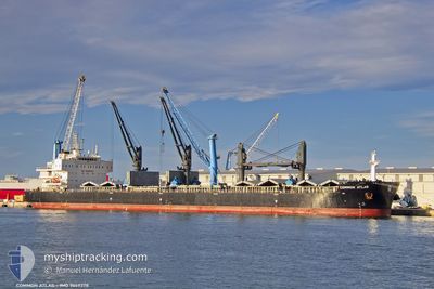
COMMON ATLAS
Cargo
Current Trip
| Trip Time | 32 days |
|---|---|
| Trip Distance | 6799.13 nm |
| AVG Speed | 11.2 Knots |
| MAX Speed | 15.4 Knots |
| Draught | 10 m |
| AVG Wind | 15.1 knots |
| MAX Wind | 34.8 knots |
| MIN Temp | -3°C / 26.6°F |
| MAX Temp | 26.4°C / 79.52°F |
| Position Received | 1 m ago |
Current Position
| Longitude | --- |
|---|---|
| Latitude | --- |
| Status | Moored |
| Speed | |
| Course | 5° |
| Area | Gulf of Mexico |
| Station | T-AIS |
| Position Received | 1 m ago |
Information
The current position of COMMON ATLAS is in Gulf of Mexico with coordinates 27.63639° / -82.56339° as reported on 2025-03-05 03:38 by AIS to our vessel tracker app. The vessel's current speed is 0 Knots and is currently inside the port of PORT MANATEE.
The vessel COMMON ATLAS (IMO: 9669378, MMSI: 538009334) is a Cargo It's sailing under the flag of [MH] Marshall Is.
In this page you can find informations about the vessels current position, last detected port calls, and current voyage information. If the vessels is not in coverage by AIS you will find the latest position.
The current position of COMMON ATLAS is detected by our AIS receivers and we are not responsible for the reliability of the data. The last position was recorded while the vessel was in Coverage by the Ais receivers of our vessel tracking app.
The current draught of COMMON ATLAS as reported by AIS is 10 meters
Weather
| Temperature | 21°C / 69.8°F |
|---|---|
| Wind Speed | 14 knots |
| Direction | 129° SE |
| Pressure | 1015 hPa |
| Humidity | 77.1 % |
| Cloud Coverage | 100 % |
Featured Company
Last Port Calls
| Port | Arrival | Departure | Time In Port |
|---|---|---|---|
| 2025-03-04 21:48 | |||
| 2025-01-28 17:13 | 2025-01-31 20:21 | 3 d | |
| 2025-01-28 13:34 | |||
| 2025-01-21 20:21 | 2025-01-24 05:19 | 2 d | |
| 2025-01-11 23:54 | 2025-01-13 22:21 | 1 d | |
| 2025-01-03 21:38 | 2025-01-09 12:57 | 5 d |
Last Trips
| Origin | Departure | Destination | Arrival | Distance | |
|---|---|---|---|---|---|
| 2025-01-31 23:21 | 2025-03-04 16:48 | 6799.13 nm | |||
| 2025-01-28 16:34 | 2025-01-28 20:13 | 13.54 nm | |||
| 2025-01-13 23:21 | 2025-01-21 21:21 | 1022.31 nm | |||
| 2025-01-09 12:57 | 2025-01-12 00:54 | 686.75 nm | |||
| 2024-12-30 23:55 | 2025-01-03 21:38 | 776.40 nm |
Events
| Time | Event | Details | Position / Dest | Info |
|---|---|---|---|---|
| 2025-03-04 22:44 | Status Changed | Moored Under way using engine |
27.63640 / -82.56342
[US] PORT MANATEE
|
Speed: Course: 5° |
| 2025-03-04 21:55 | STOP Moving |
27.63604 / -82.56376
[US] PORT MANATEE
|
Speed: 0.3 kn Course: 13° |
|
| 2025-03-04 21:48 | PORT ARRIVAL |
|
27.63621 / -82.56603
[US] PORT MANATEE
|
Speed: 1.5 kn Course: 77° |
| 2025-03-04 21:15 | Draught Changed | 10 9.8 |
27.65788 / -82.60137
USPME
|
Speed: 6 kn Course: 92.2° |
| 2025-03-04 21:15 | ETA Changed | 2025/03/04 15:00 2025/02/28 05:05 |
27.65788 / -82.60137
USPME
|
Speed: 6 kn Course: 92.2° |
| 2025-03-04 19:17 | Detected in Sea | United States part of the Gulf of Mexico |
27.59508 / -83.00007
Gulf of Mexico
|
Speed: 10 kn Course: 110.2° |
| 2025-03-04 19:17 | Status Changed | Under way using engine Default |
27.59508 / -83.00007
USPME
|
Speed: 8.3 kn Course: 121° |
| 2025-03-04 19:17 | IN Coverage |
27.59508 / -83.00007
Gulf of Mexico
|
Speed: 10 kn Course: 110.2° |
|
| 2025-03-01 18:59 | Status Changed | Default Under way using engine |
21.32234 / -74.00285
USPME
|
Speed: 11.7 kn Course: 239.8° |
| 2025-03-01 18:50 | OUT of Coverage |
21.33762 / -73.97472
North Atlantic Ocean
|
Speed: 11.7 kn Course: 239.8° |