
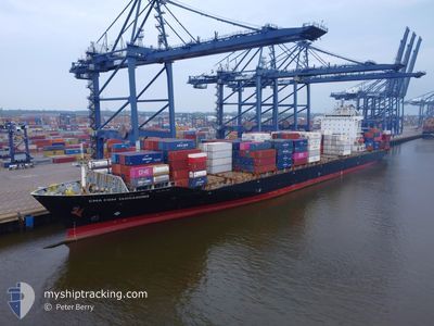
CMA CGM TARRAGONA
Container Ship
Current Trip
| Time Travelled | 6 days |
|---|---|
| Remaining Time | 8 h, 51 mins |
| Distance Travelled | 1059.06 nm |
| Remaining Distance | 59.34 nm |
| AVG Speed | 8.9 Knots |
| MAX Speed | 14.5 Knots |
| AVG Wind | 10 knots |
| MAX Wind | 25 knots |
| MIN Temp | 9.3°C / 48.74°F |
| MAX Temp | 17.3°C / 63.14°F |
| Draught | 12.5 m |
| Position Received | 20 m ago |
Current Position
| Longitude | --- |
|---|---|
| Latitude | --- |
| Status | Under way using engine |
| Speed | 0.3 Knots |
| Course | 128° |
| Area | Alboran Sea |
| Station | T-AIS |
| Position Received | 20 m ago |
Info
Information
The current position of CMA CGM TARRAGONA is in Alboran Sea with coordinates 36.25605° / -4.50731° as reported on 2025-02-27 21:34 by AIS to our vessel tracker app. The vessel's current speed is 0.3 Knots and is heading at the port of TANGER MED. The estimated time of arrival as calculated by MyShipTracking vessel tracking app is 2025-02-28 06:46 LT
The vessel CMA CGM TARRAGONA (IMO: 9471214, MMSI: 256208000) is a Container Ship that was built in 2010 ( 15 years old ). It's sailing under the flag of [MT] Malta.
In this page you can find informations about the vessels current position, last detected port calls, and current voyage information. If the vessels is not in coverage by AIS you will find the latest position.
The current position of CMA CGM TARRAGONA is detected by our AIS receivers and we are not responsible for the reliability of the data. The last position was recorded while the vessel was in Coverage by the Ais receivers of our vessel tracking app.
The current draught of CMA CGM TARRAGONA as reported by AIS is 12.5 meters
Weather
| Temperature | 15.8°C / 60.44°F |
|---|---|
| Wind Speed | 4 knots |
| Direction | 209° SSW |
| Pressure | 1017.6 hPa |
| Humidity | 77 % |
| Cloud Coverage | 100 % |
Featured Company
Last Port Calls
| Port | Arrival | Departure | Time In Port |
|---|---|---|---|
| 2025-02-21 05:57 | 2025-02-21 20:36 | 14 h | |
| 2025-02-17 15:48 | 2025-02-18 09:29 | 17 h | |
| 2025-02-16 09:24 | 2025-02-16 17:09 | 7 h | |
| 2025-02-15 02:04 | 2025-02-16 04:27 | 1 d | |
| 2025-02-12 22:30 | 2025-02-14 15:33 | 1 d | |
| 2025-02-11 01:51 | 2025-02-11 21:42 | 19 h | |
| 2025-02-04 12:18 | 2025-02-06 03:45 | 1 d | |
| 2025-01-26 20:30 | 2025-01-27 21:28 | 1 d | |
| 2025-01-24 14:06 | 2025-01-26 01:07 | 1 d | |
| 2025-01-17 23:51 | 2025-01-19 15:06 | 1 d |
Most Visited Ports (Last year)
| Port | Arrivals | |
|---|---|---|
| 9 | ||
| 9 | ||
| 9 | ||
| 9 | ||
| 9 | ||
| 8 |
Last Trips
| Origin | Departure | Destination | Arrival | Distance | |
|---|---|---|---|---|---|
| 2025-02-18 12:29 | 2025-02-21 06:57 | 813.50 nm | |||
| 2025-02-16 20:09 | 2025-02-17 18:48 | 289.31 nm | |||
| 2025-02-16 07:27 | 2025-02-16 12:24 | 64.55 nm | |||
| 2025-02-14 18:33 | 2025-02-15 05:04 | 52.88 nm | |||
| 2025-02-11 23:42 | 2025-02-13 01:30 | 355.28 nm | |||
| 2025-02-06 04:45 | 2025-02-11 03:51 | 680.90 nm | |||
| 2025-01-27 22:28 | 2025-02-04 13:18 | 2699.55 nm | |||
| 2025-01-26 02:07 | 2025-01-26 21:30 | 300.59 nm | |||
| 2025-01-19 16:06 | 2025-01-24 15:06 | 133.50 nm | |||
| 2025-01-17 13:22 | 2025-01-18 00:51 | 147.81 nm |
Events
| Time | Event | Details | Position / Dest | Info |
|---|---|---|---|---|
| 2025-02-27 21:38 | Status Changed | Default Under way using engine |
36.25635 / -4.50679
MAPTM
|
Speed: 0.3 kn Course: 128° |
| 2025-02-27 21:33 | STOP Moving |
36.25591 / -4.50754
MAPTM
|
Speed: 0.3 kn Course: 129° |
|
| 2025-02-27 21:28 | Status Changed | Under way using engine Default |
36.25556 / -4.50790
MAPTM
|
Speed: 0.5 kn Course: 149° |
| 2025-02-27 21:17 | Status Changed | Default Under way using engine |
36.25432 / -4.50937
MAPTM
|
Speed: 0.9 kn Course: 176° |
| 2025-02-27 20:52 | Status Changed | Under way using engine Default |
36.25539 / -4.51201
MAPTM
|
Speed: 1.9 kn Course: 206° |
| 2025-02-27 20:38 | Status Changed | Default Under way using engine |
36.26088 / -4.50960
MAPTM
|
Speed: 2.1 kn Course: 208° |
| 2025-02-27 19:53 | Status Changed | Under way using engine Default |
36.27975 / -4.46774
MAPTM
|
Speed: 0.8 kn Course: 165° |
| 2025-02-27 19:49 | Status Changed | Default Under way using engine |
36.27851 / -4.46808
MAPTM
|
Speed: 0.7 kn Course: 172° |
| 2025-02-27 19:17 | Status Changed | Under way using engine Default |
36.27331 / -4.47159
MAPTM
|
Speed: 0.8 kn Course: 152° |
| 2025-02-27 18:32 | Status Changed | Default Under way using engine |
36.26613 / -4.48058
MAPTM
|
Speed: 0.9 kn Course: 135° |