
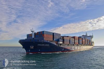
CMA CGM LOUGA
Cargo A
Current Trip
| Time Travelled | 2 days |
|---|---|
| Remaining Time | --- |
| Distance Travelled | 926.06 nm |
| Remaining Distance | --- |
| AVG Speed | 14.6 Knots |
| MAX Speed | 19.4 Knots |
| AVG Wind | 14.7 knots |
| MAX Wind | 30.5 knots |
| MIN Temp | -4.2°C / 24.44°F |
| MAX Temp | 7.1°C / 44.78°F |
| Draught | 9.2 m |
| Position Received | 2 d ago |
Current Position
| Longitude | --- |
|---|---|
| Latitude | --- |
| Status | Under way using engine |
| Speed | 8.7 Knots |
| Course | 90.8° |
| Area | North Atlantic Ocean |
| Station | T-AIS |
| Position Received | 2 d ago |
Info
Information
The current position of CMA CGM LOUGA is in North Atlantic Ocean with coordinates 38.75450° / -74.62798° as reported on 2026-01-03 22:14 by AIS to our vessel tracker app. The vessel's current speed is 8.7 Knots and is heading at the port of ROTTERDAM. The estimated time of arrival as calculated by MyShipTracking vessel tracking app is 2026-01-13 07:00 LT
The vessel CMA CGM LOUGA (IMO: 9745550, MMSI: 248655000) is a Cargo A It's sailing under the flag of [MT] Malta.
In this page you can find informations about the vessels current position, last detected port calls, and current voyage information. If the vessels is not in coverage by AIS you will find the latest position.
The current position of CMA CGM LOUGA is detected by our AIS receivers and we are not responsible for the reliability of the data. The last position was recorded while the vessel was in Coverage by the Ais receivers of our vessel tracking app.
The current draught of CMA CGM LOUGA as reported by AIS is 9.2 meters
Weather
| Temperature | 4.5°C / 40.1°F |
|---|---|
| Wind Speed | 22 knots |
| Direction | 306° NW |
| Pressure | 1020.4 hPa |
| Humidity | 77.9 % |
| Cloud Coverage | 100 % |
Featured Company
Last Port Calls
| Port | Arrival | Departure | Time In Port |
|---|---|---|---|
| 2026-01-02 19:17 | 2026-01-03 08:31 | 13 h | |
| 2025-12-28 00:47 | 2025-12-28 09:58 | 9 h | |
| 2025-12-06 21:57 | 2025-12-07 23:47 | 1 d | |
| 2025-11-30 18:32 | 2025-12-01 22:59 | 1 d | |
| 2025-11-26 05:54 | 2025-11-26 16:55 | 11 h | |
| 2025-11-01 20:38 | 2025-11-02 19:14 | 22 h |
Last Trips
| Origin | Departure | Destination | Arrival | Distance | |
|---|---|---|---|---|---|
| 2025-12-28 09:58 | 2026-01-02 19:17 | 1840.25 nm | |||
| 2025-12-07 23:47 | 2025-12-28 00:47 | 7600.78 nm | |||
| 2025-12-01 22:59 | 2025-12-06 21:57 | 1781.55 nm | |||
| 2025-11-26 16:55 | 2025-11-30 18:32 | 1611.15 nm | |||
| 2025-11-02 19:14 | 2025-11-26 05:54 | 7718.67 nm | |||
| 2025-10-29 07:59 | 2025-11-01 20:38 | 1151.91 nm |
Events
| Time | Event | Details | Position / Dest | Info |
|---|---|---|---|---|
| 2026-01-03 22:19 | Status Changed | Default Under way using engine |
38.75445 / -74.61301
NLRTM
|
Speed: 8.7 kn Course: 90.8° |
| 2026-01-03 22:14 | OUT of Coverage |
38.75450 / -74.62798
North Atlantic Ocean
NLRTM
|
Speed: 8.7 kn Course: 90.8° |
|
| 2026-01-03 22:03 | Status Changed | Under way using engine Default |
38.75513 / -74.66213
NLRTM
|
Speed: 8.8 kn Course: 91° |
| 2026-01-03 21:51 | Status Changed | Default Under way using engine |
38.75588 / -74.70032
NLRTM
|
Speed: 8.7 kn Course: 95° |
| 2026-01-03 20:20 | Status Changed | Under way using engine Default |
38.75930 / -74.98244
NLRTM
|
Speed: 8 kn Course: 99° |
| 2026-01-03 20:19 | Status Changed | Default Under way using engine |
38.75948 / -74.98525
NLRTM
|
Speed: 8.6 kn Course: 120.2° |
| 2026-01-03 20:01 | Status Changed | Under way using engine Default |
38.78195 / -75.03133
NLRTM
|
Speed: 8.7 kn Course: 121° |
| 2026-01-03 19:55 | IN Coverage |
38.78195 / -75.03133
North Atlantic Ocean
NLRTM
|
Speed: 9.2 kn Course: 130.1° |
|
| 2026-01-03 18:27 | Status Changed | Default Under way using engine |
39.11312 / -75.21206
NLRTM
|
Speed: 17.4 kn Course: 144.7° |
| 2026-01-03 18:20 | OUT of Coverage |
39.14147 / -75.23730
North Atlantic Ocean
NLRTM
|
Speed: 17.4 kn Course: 144.7° |