
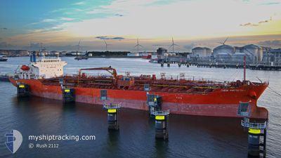
CHEM AMSTERDAM
Oil/Chemical Tanker
Current Trip
USFPO
| Time Travelled | 23 h, 11 mins |
|---|---|
| Remaining Time | --- |
| Distance Travelled | 223.17 nm |
| Remaining Distance | --- |
| AVG Speed | 9.7 Knots |
| MAX Speed | 12.7 Knots |
| AVG Wind | 17.1 knots |
| MAX Wind | 23 knots |
| MIN Temp | 10.9°C / 51.62°F |
| MAX Temp | 20.6°C / 69.08°F |
| Draught | 5.5 m |
| Position Received | 2 m ago |
Current Position
| Longitude | --- |
|---|---|
| Latitude | --- |
| Status | Under way using engine |
| Speed | 12.6 Knots |
| Course | 264.6° |
| Area | North Atlantic Ocean |
| Station | T-AIS |
| Position Received | 2 m ago |
Info
Information
The current position of CHEM AMSTERDAM is in North Atlantic Ocean with coordinates 29.34442° / -94.74714° as reported on 2025-01-15 20:56 by AIS to our vessel tracker app. The vessel's current speed is 12.6 Knots
The vessel CHEM AMSTERDAM (IMO: 9640138, MMSI: 538005215) is a Oil/Chemical Tanker that was built in 2013 ( 12 years old ). It's sailing under the flag of [MH] Marshall Is.
In this page you can find informations about the vessels current position, last detected port calls, and current voyage information. If the vessels is not in coverage by AIS you will find the latest position.
The current position of CHEM AMSTERDAM is detected by our AIS receivers and we are not responsible for the reliability of the data. The last position was recorded while the vessel was in Coverage by the Ais receivers of our vessel tracking app.
The current draught of CHEM AMSTERDAM as reported by AIS is 5.5 meters
Weather
| Temperature | 11°C / 51.8°F |
|---|---|
| Wind Speed | 15 knots |
| Direction | 37° NE |
| Pressure | 1026.2 hPa |
| Humidity | 84.8 % |
| Cloud Coverage | 100 % |
Featured Company
Last Port Calls
| Port | Arrival | Departure | Time In Port |
|---|---|---|---|
| 2025-01-11 15:23 | 2025-01-14 21:47 | 3 d | |
| 2024-12-30 23:44 | 2024-12-31 01:26 | 1 h | |
| 2024-12-13 07:06 | 2024-12-15 15:18 | 2 d | |
| 2024-12-09 18:44 | 2024-12-11 09:31 | 1 d | |
| 2024-12-09 08:22 | 2024-12-09 08:35 | 12 m | |
| 2024-12-09 03:12 | 2024-12-09 07:23 | 4 h | |
| 2024-12-08 19:59 | 2024-12-09 03:02 | 7 h | |
| 2024-12-08 07:29 | 2024-12-08 16:08 | 8 h | |
| 2024-12-07 22:26 | 2024-12-08 02:23 | 3 h | |
| 2024-12-07 01:35 | 2024-12-07 19:46 | 18 h |
Most Visited Ports (Last year)
| Port | Arrivals | |
|---|---|---|
| 7 | ||
| 5 | ||
| 3 | ||
| 3 | ||
| 2 | ||
| 2 |
Last Trips
| Origin | Departure | Destination | Arrival | Distance | |
|---|---|---|---|---|---|
| 2024-12-30 20:26 | 2025-01-11 09:23 | 1631.00 nm | |||
| 2024-12-15 16:18 | 2024-12-30 18:44 | 4063.60 nm | |||
| 2024-12-11 10:31 | 2024-12-13 08:06 | 372.87 nm | |||
| 2024-12-09 09:35 | 2024-12-09 19:44 | 4.69 nm | |||
| 2024-12-09 08:23 | 2024-12-09 09:22 | 4.74 nm | |||
| 2024-12-09 04:02 | 2024-12-09 04:12 | 0.38 nm | |||
| 2024-12-08 17:08 | 2024-12-08 20:59 | 0.14 nm | |||
| 2024-12-08 03:23 | 2024-12-08 08:29 | 0.23 nm | |||
| 2024-12-07 20:46 | 2024-12-07 23:26 | 23.73 nm | |||
| 2024-12-03 09:04 | 2024-12-07 02:35 | 925.12 nm |
Events
| Time | Event | Details | Position / Dest | Info |
|---|---|---|---|---|
| 2025-01-15 20:48 | Change Sea Area | United States part of the Gulf of Mexico United States part of the North Atlantic Ocean |
29.34631 / -94.71742
Gulf of Mexico
|
Speed: 12.2 kn Course: 268.3° |
| 2025-01-15 20:48 | Status Changed | Under way using engine Default |
29.34634 / -94.71593
USFPO
|
Speed: 12.5 kn Course: 284° |
| 2025-01-15 20:31 | IN Coverage |
29.34631 / -94.71742
Gulf of Mexico
|
Speed: 12.2 kn Course: 268.3° |
|
| 2025-01-14 21:47 | START Moving | 1.52 nm, East of FREEPORT (TX) |
28.94194 / -95.30370
USFPO
|
Speed: 9.6 kn Course: 129° |
| 2025-01-14 21:47 | PORT DEPARTURE |
|
28.94194 / -95.30370
USFPO
|
Speed: 0.3 kn Course: 111° |
| 2025-01-11 15:43 | STOP Moving |
28.94336 / -95.31694
[US] FREEPORT (TX)
|
Speed: Course: 108° |
|
| 2025-01-11 15:23 | PORT ARRIVAL |
|
28.94189 / -95.31422
[US] FREEPORT (TX)
|
Speed: 6.2 kn Course: 282° |
| 2025-01-11 13:59 | START Moving | 8.77 nm, East of FREEPORT (TX) |
28.92934 / -95.16614
USFPO
|
Speed: 3.9 kn Course: 256° |
| 2025-01-10 15:53 | STOP Moving | 8.96 nm, East of FREEPORT (TX) |
28.92735 / -95.16253
USFPO
|
Speed: 0.2 kn Course: 357° |
| 2025-01-10 04:47 | START Moving | 10.11 nm, East of FREEPORT (TX) |
28.91770 / -95.14181
USFPO
|
Speed: 3.4 kn Course: 64° |