
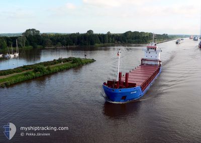
CARLOW
General Cargo
Current Trip
| Time Travelled | 3 days |
|---|---|
| Remaining Time | --- |
| Distance Travelled | 349.69 nm |
| Remaining Distance | --- |
| AVG Speed | 10 Knots |
| MAX Speed | 11.1 Knots |
| AVG Wind | 9.9 knots |
| MAX Wind | 18.5 knots |
| MIN Temp | 11.9°C / 53.42°F |
| MAX Temp | 19.6°C / 67.28°F |
| Draught | 4.3 m |
| Position Received | 2 d ago |
Current Position
| Longitude | 18.38438° |
|---|---|
| Latitude | 40.54164° |
| Status | Under way using engine |
| Speed | 9.7 Knots |
| Course | 307.9° |
| Area | Adriatic Sea |
| Station | T-AIS |
| Position Received | 2 d ago |
Info
Information
The current position of CARLOW is in Adriatic Sea with coordinates 40.54164° / 18.38438° as reported on 2024-05-03 10:56 by AIS to our vessel tracker app. The vessel's current speed is 9.7 Knots and is heading at the port of MANFREDONIA. The estimated time of arrival as calculated by MyShipTracking vessel tracking app is 2024-05-03 20:30 LT
The vessel CARLOW (IMO: 9127162, MMSI: 371949000) is a General Cargo that was built in 1995 ( 29 years old ). It's sailing under the flag of [PA] Panama.
In this page you can find informations about the vessels current position, last detected port calls, and current voyage information. If the vessels is not in coverage by AIS you will find the latest position.
The current position of CARLOW is detected by our AIS receivers and we are not responsible for the reliability of the data. The last position was recorded while the vessel was in Coverage by the Ais receivers of our vessel tracking app.
The current draught of CARLOW as reported by AIS is 4.3 meters
Weather
| Temperature | 16.9°C / 62.42°F |
|---|---|
| Wind Speed | 2 knots |
| Direction | 34° NE |
| Pressure | 1016.4 hPa |
| Humidity | 75.8 % |
| Cloud Coverage | 72 % |
Featured Company
Last Port Calls
| Port | Arrival | Departure | Time In Port |
|---|---|---|---|
| 2024-04-29 15:16 | 2024-05-02 13:32 | 2 d | |
| 2024-04-25 04:44 | 2024-04-26 14:52 | 1 d | |
| 2024-04-13 08:35 | 2024-04-18 04:25 | 4 d | |
| 2024-04-08 05:45 | 2024-04-10 12:17 | 2 d | |
| 2024-04-02 13:05 | 2024-04-06 14:11 | 4 d | |
| 2024-03-23 04:44 | 2024-03-27 15:55 | 4 d | |
| 2024-03-18 07:34 | 2024-03-18 22:19 | 14 h | |
| 2024-03-13 05:01 | 2024-03-15 05:59 | 2 d | |
| 2024-03-08 12:24 | 2024-03-12 05:42 | 3 d | |
| 2024-03-05 16:00 | 2024-03-07 10:46 | 1 d |
Last Trips
| Origin | Departure | Destination | Arrival | Distance | |
|---|---|---|---|---|---|
| 2024-04-26 16:52 | 2024-04-29 18:16 | 736.61 nm | |||
| 2024-04-18 07:25 | 2024-04-25 06:44 | 633.69 nm | |||
| 2024-04-10 14:17 | 2024-04-13 11:35 | 744.53 nm | |||
| 2024-04-06 16:11 | 2024-04-08 07:45 | 121.75 nm | |||
| 2024-03-27 17:55 | 2024-04-02 15:05 | 503.97 nm | |||
| 2024-03-18 23:19 | 2024-03-23 06:44 | 471.28 nm | |||
| 2024-03-15 07:59 | 2024-03-18 08:34 | 651.03 nm | |||
| 2024-03-12 07:42 | 2024-03-13 07:01 | 124.98 nm | |||
| 2024-03-07 12:46 | 2024-03-08 14:24 | 258.21 nm | |||
| 2024-02-29 20:12 | 2024-03-05 18:00 | 1250.02 nm |
Events
| Time | Event | Details | Position / Dest | Info |
|---|---|---|---|---|
| 2024-05-03 11:02 | Status Changed | Default Under way using engine |
40.55277 / 18.36516
IT MFR
|
Speed: 9.7 kn Course: 307.9° |
| 2024-05-03 10:56 | OUT of Coverage |
40.54164 / 18.38438
Adriatic Sea
IT MFR
|
Speed: 9.7 kn Course: 307.9° |
|
| 2024-05-03 09:17 | ETA Changed | 2024/05/03 20:30 2024/05/03 17:30 |
40.35454 / 18.63707
IT MFR
|
Speed: 10 kn Course: 315.5° |
| 2024-05-03 08:20 | Detected in Sea | Italian part of the Adriatic Sea |
40.24033 / 18.78670
Adriatic Sea
IT MFR
|
Speed: 10 kn Course: 314.9° |
| 2024-05-03 08:19 | Status Changed | Under way using engine Default |
40.23899 / 18.78842
IT MFR
|
Speed: 10.1 kn Course: 315° |
| 2024-05-03 08:19 | IN Coverage |
40.24033 / 18.78670
Adriatic Sea
IT MFR
|
Speed: 10 kn Course: 314.9° |
|
| 2024-05-03 00:12 | Status Changed | Default Under way using engine |
39.15500 / 19.94833
IT MFR
|
Speed: 11.1 kn Course: 324.1° |
| 2024-05-03 00:12 | OUT of Coverage |
39.15382 / 19.95060
Ionian Sea
IT MFR
|
Speed: 11.1 kn Course: 324.1° |
|
| 2024-05-02 13:32 | PORT DEPARTURE |
|
38.26279 / 21.73307
IT MFR
|
Speed: 7.1 kn Course: 337° |
| 2024-05-02 13:29 | START Moving |
38.25542 / 21.73380
[GR] PATRA
|
Speed: 6.3 kn Course: 4° |