

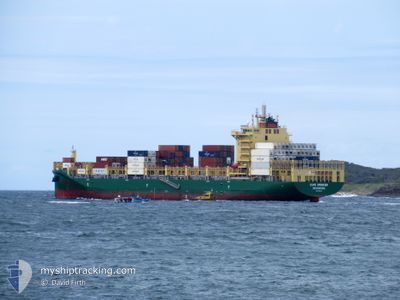
CAPE SPENCER
Cargo

Current Trip
| Time Travelled | 8 days |
|---|---|
| Remaining Time | 9 days |
| Distance Travelled | 2808.24 nm |
| Remaining Distance | 4085.05 nm |
| AVG Speed | 13.3 Knots |
| MAX Speed | 18.5 Knots |
| AVG Wind | 15.9 knots |
| MAX Wind | 29.9 knots |
| MIN Temp | 16°C / 60.8°F |
| MAX Temp | 27°C / 80.6°F |
| Draught | 11.3 m |
| Position Received | 8 d ago |
Current Position
| Longitude | --- |
|---|---|
| Latitude | --- |
| Status | Under way using engine |
| Speed | 15.1 Knots |
| Course | 87.7° |
| Area | South Pacific Ocean |
| Station | T-AIS |
| Position Received | 8 d ago |
Information
The current position of CAPE SPENCER is in South Pacific Ocean with coordinates -37.42554° / 177.23636° as reported on 2025-02-10 01:48 by AIS to our vessel tracker app. The vessel's current speed is 15.1 Knots and is heading at the port of MANZANILLO. The estimated time of arrival as calculated by MyShipTracking vessel tracking app is 2025-02-27 07:55 LT
The vessel CAPE SPENCER (IMO: 9950129, MMSI: 219032229) is a Cargo It's sailing under the flag of [DK] Denmark.
In this page you can find informations about the vessels current position, last detected port calls, and current voyage information. If the vessels is not in coverage by AIS you will find the latest position.
The current position of CAPE SPENCER is detected by our AIS receivers and we are not responsible for the reliability of the data. The last position was recorded while the vessel was in Coverage by the Ais receivers of our vessel tracking app.
The current draught of CAPE SPENCER as reported by AIS is 11.3 meters
Weather
| Temperature | 26.8°C / 80.24°F |
|---|---|
| Wind Speed | 10 knots |
| Direction | 303° WNW |
| Pressure | 1014.5 hPa |
| Humidity | 82.2 % |
| Cloud Coverage | 100 % |


Featured Company
Last Port Calls
| Port | Arrival | Departure | Time In Port |
|---|---|---|---|
| 2025-02-08 10:16 | 2025-02-09 21:55 | 1 d | |
| 2025-02-02 02:06 | 2025-02-03 05:45 | 1 d | |
| 2025-01-30 00:02 | 2025-01-31 00:18 | 1 d | |
| 2025-01-27 14:58 | 2025-01-28 13:33 | 22 h | |
| 2025-01-24 18:55 | 2025-01-25 04:12 | 9 h | |
| 2025-01-02 10:59 | 2025-01-03 11:43 | 1 d | |
| 2024-12-29 14:33 | 2024-12-30 15:42 | 1 d | |
| 2024-12-14 04:51 | 2024-12-14 22:38 | 17 h | |
| 2024-12-12 13:28 | 2024-12-13 15:48 | 1 d | |
| 2024-12-11 18:12 | 2024-12-12 06:28 | 12 h |
Last Trips
| Origin | Departure | Destination | Arrival | Distance | |
|---|---|---|---|---|---|
| 2025-02-03 16:45 | 2025-02-08 23:16 | 1783.59 nm | |||
| 2025-01-31 11:18 | 2025-02-02 13:06 | 588.94 nm | |||
| 2025-01-28 23:33 | 2025-01-30 11:02 | 567.13 nm | |||
| 2025-01-25 15:12 | 2025-01-28 00:58 | 820.48 nm | |||
| 2025-01-03 06:43 | 2025-01-25 05:55 | 7719.74 nm | |||
| 2024-12-30 10:42 | 2025-01-02 05:59 | 1069.19 nm | |||
| 2024-12-14 23:38 | 2024-12-29 09:33 | 4550.86 nm | |||
| 2024-12-13 16:48 | 2024-12-14 05:51 | 188.76 nm | |||
| 2024-12-12 06:28 | 2024-12-12 14:28 | 81.48 nm | |||
| 2024-12-06 20:25 | 2024-12-11 18:12 | 520.36 nm |
Events
| Time | Event | Details | Position / Dest | Info |
|---|---|---|---|---|
| 2025-02-10 01:54 | Status Changed | Default Under way using engine |
-37.42453 / 177.26814
NZTRG > PAMIT
|
Speed: 15.1 kn Course: 87.7° |
| 2025-02-10 01:48 | OUT of Coverage |
-37.42554 / 177.23636
South Pacific Ocean
NZTRG > PAMIT
|
Speed: 15.1 kn Course: 87.7° |
|
| 2025-02-09 23:59 | Status Changed | Under way using engine Default |
-37.45162 / 176.66197
NZTRG > PAMIT
|
Speed: 15.1 kn Course: 87° |
| 2025-02-09 23:47 | Status Changed | Default Under way using engine |
-37.45483 / 176.59653
NZTRG > PAMIT
|
Speed: 15.1 kn Course: 86.8° |
| 2025-02-09 23:37 | Status Changed | Under way using engine Default |
-37.45698 / 176.54399
NZTRG > PAMIT
|
Speed: 15.1 kn Course: 86° |
| 2025-02-09 23:23 | Status Changed | Default Under way using engine |
-37.46025 / 176.46872
NZTRG > PAMIT
|
Speed: 15.4 kn Course: 70.9° |
| 2025-02-09 23:09 | Status Changed | Under way using engine Default |
-37.47429 / 176.39699
NZTRG > PAMIT
|
Speed: 15.6 kn Course: 70° |
| 2025-02-09 23:06 | Status Changed | Default Under way using engine |
-37.47905 / 176.37994
NZTRG > PAMIT
|
Speed: 15.4 kn Course: 70.8° |
| 2025-02-09 21:55 | PORT DEPARTURE |
|
-37.63953 / 176.16941
NZTRG > PAMIT
|
Speed: 7.9 kn Course: 306° |
| 2025-02-09 21:40 | START Moving |
-37.66266 / 176.17617
[NZ] TAURANGA
|
Speed: 3.5 kn Course: 28° |