
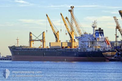
BRIGHT STAR
Bulk Carrier
Current Trip
| Time Travelled | 1 day |
|---|---|
| Remaining Time | 3 days |
| Distance Travelled | 193.94 nm |
| Remaining Distance | 811.06 nm |
| AVG Speed | 10.6 Knots |
| MAX Speed | 14.4 Knots |
| AVG Wind | 12.1 knots |
| MAX Wind | 24.2 knots |
| MIN Temp | 11.2°C / 52.16°F |
| MAX Temp | 17.7°C / 63.86°F |
| Draught | 10.1 m |
| Position Received | 12 h, 44 m ago |
Current Position
| Longitude | -58.04862° |
|---|---|
| Latitude | -34.65820° |
| Status | Under way using engine |
| Speed | 11.5 Knots |
| Course | 108° |
| Area | Rio de La Plata |
| Station | T-AIS |
| Position Received | 12 h, 44 m ago |
Info
Information
The current position of BRIGHT STAR is in Rio de La Plata with coordinates -34.65820° / -58.04862° as reported on 2024-05-08 15:04 by AIS to our vessel tracker app. The vessel's current speed is 11.5 Knots and is heading at the port of PARANAGUA. The estimated time of arrival as calculated by MyShipTracking vessel tracking app is 2024-05-12 07:14 LT
The vessel BRIGHT STAR (IMO: 9481960, MMSI: 636018508) is a Bulk Carrier that was built in 2011 ( 13 years old ). It's sailing under the flag of [LR] Liberia.
In this page you can find informations about the vessels current position, last detected port calls, and current voyage information. If the vessels is not in coverage by AIS you will find the latest position.
The current position of BRIGHT STAR is detected by our AIS receivers and we are not responsible for the reliability of the data. The last position was recorded while the vessel was in Coverage by the Ais receivers of our vessel tracking app.
The current draught of BRIGHT STAR as reported by AIS is 10.1 meters
Weather
| Temperature | 12°C / 53.6°F |
|---|---|
| Wind Speed | 22 knots |
| Direction | 241° WSW |
| Pressure | 1017.9 hPa |
| Humidity | 57.4 % |
| Cloud Coverage | --- |
Featured Company
Last Port Calls
| Port | Arrival | Departure | Time In Port |
|---|---|---|---|
| 2024-05-03 12:46 | 2024-05-08 03:08 | 4 d | |
| 2024-04-23 19:37 | 2024-04-26 13:13 | 2 d | |
| 2024-04-17 02:59 | 2024-04-18 22:23 | 1 d | |
| 2024-03-12 15:16 | 2024-03-18 09:10 | 5 d |
Most Visited Ports (Last year)
| Port | Arrivals | |
|---|---|---|
| 2 | ||
| 2 | ||
| 2 | ||
| 1 | ||
| 1 | ||
| 1 |
Last Trips
| Origin | Departure | Destination | Arrival | Distance | |
|---|---|---|---|---|---|
| 2024-04-26 10:13 | 2024-05-03 09:46 | 1124.98 nm | |||
| 2024-04-18 19:23 | 2024-04-23 16:37 | 19.20 nm | |||
| 2024-03-18 12:10 | 2024-04-16 23:59 | 7149.09 nm | |||
| 2024-02-15 07:38 | 2024-03-12 18:16 | 3811.13 nm |
Events
| Time | Event | Details | Position / Dest | Info |
|---|---|---|---|---|
| 2024-05-08 21:39 | START Moving | 8.03 nm, North of LA PLATA |
-34.71525 / -57.88642
PARANAGUA
|
Speed: 3.7 kn Course: 306° |
| 2024-05-08 16:13 | STOP Moving | 8.02 nm, North of LA PLATA |
-34.71570 / -57.87832
PARANAGUA
|
Speed: 0.3 kn Course: 292° |
| 2024-05-08 15:08 | Status Changed | Default Under way using engine |
-34.66270 / -58.03404
PARANAGUA
|
Speed: 11.5 kn Course: 108° |
| 2024-05-08 15:04 | OUT of Coverage |
-34.65820 / -58.04862
Rio de La Plata
PARANAGUA
|
Speed: 11.5 kn Course: 108° |
|
| 2024-05-08 11:15 | Draught Changed | 10.1 6.2 |
-34.26043 / -58.66568
PARANAGUA
|
Speed: 10.2 kn Course: 109° |
| 2024-05-08 11:15 | Destination Changed | PARANAGUA RECALADA |
-34.26043 / -58.66568
PARANAGUA
|
Speed: 10.2 kn Course: 109° |
| 2024-05-08 11:15 | ETA Changed | 2024/05/11 04:00 2025/04/29 10:00 |
-34.26043 / -58.66568
PARANAGUA
|
Speed: 10.2 kn Course: 109° |
| 2024-05-08 10:35 | Status Changed | Under way using engine Default |
-34.23213 / -58.78877
RECALADA
|
Speed: 10.8 kn Course: 131° |
| 2024-05-08 10:29 | Status Changed | Default Under way using engine |
-34.22115 / -58.80685
RECALADA
|
Speed: 10.7 kn Course: 131° |
| 2024-05-08 09:37 | Status Changed | Under way using engine Default |
-34.15015 / -58.92657
RECALADA
|
Speed: 8.1 kn Course: 66° |