
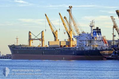
BRIGHT STAR
Bulk Carrier
Current Trip
| Time Travelled | 4 days |
|---|---|
| Remaining Time | --- |
| Distance Travelled | 1015.41 nm |
| Remaining Distance | --- |
| AVG Speed | 11.7 Noeuds |
| MAX Speed | 14.8 Noeuds |
| AVG Wind | 14 knots |
| MAX Wind | 24.2 knots |
| MIN Temp | 11.2°C / 52.16°F |
| MAX Temp | 25.9°C / 78.62°F |
| Tirant d eau | 10.1 m |
| Position reçue | 2 d depuis |
Current Position
| Longitude | -54.61700° |
|---|---|
| Latitude | -34.96928° |
| Etat | Under way using engine |
| Vitesse | 13.8 Noeuds |
| Parcours | 57° |
| Zone | South Atlantic Ocean |
| Station | T-AIS |
| Position reçue | 2 d depuis |
Info
Information
The current position of BRIGHT STAR is in South Atlantic Ocean with coordinates -34.96928° / -54.61700° as reported on 2024-05-09 13:16 by AIS to our vessel tracker app. The vessel's current speed is 13.8 Noeuds
The vessel BRIGHT STAR (IMO: 9481960, MMSI: 636018508) is a Bulk Carrier that was built in 2011 ( 13 Age ). It's sailing under the flag of [LR] Liberia.
In this page you can find informations about the vessels current position, last detected port calls, and current voyage information. If the vessels is not in coverage by AIS you will find the latest position.
The current position of BRIGHT STAR is detected by our AIS receivers and we are not responsible for the reliability of the data. The last position was recorded while the vessel was in Coverage by the Ais receivers of our vessel tracking app.
The current draught of BRIGHT STAR as reported by AIS is 10.1 meters
Weather
| Temperature | 21.4°C / 70.52°F |
|---|---|
| Wind Speed | 1 knots |
| Direction | 233° SW |
| Pressure | 1010.8 hPa |
| Humidity | 98.9 % |
| Cloud Coverage | 74 % |
Featured Company
Last Port Calls
| Port | Arrival | Departure | Time In Port |
|---|---|---|---|
| 2024-05-03 12:46 | 2024-05-08 03:08 | 4 d | |
| 2024-04-23 19:37 | 2024-04-26 13:13 | 2 d | |
| 2024-04-17 02:59 | 2024-04-18 22:23 | 1 d | |
| 2024-03-12 15:16 | 2024-03-18 09:10 | 5 d |
Most Visited Ports (Last year)
| Port | Arrivals | |
|---|---|---|
| 2 | ||
| 2 | ||
| 2 | ||
| 1 | ||
| 1 | ||
| 1 |
Last Trips
| Origin | Departure | Destination | Arrival | Distance | |
|---|---|---|---|---|---|
| 2024-04-26 10:13 | 2024-05-03 09:46 | 1124.98 nm | |||
| 2024-04-18 19:23 | 2024-04-23 16:37 | 19.20 nm | |||
| 2024-03-18 12:10 | 2024-04-16 23:59 | 7149.09 nm | |||
| 2024-02-15 07:38 | 2024-03-12 18:16 | 3811.13 nm |
Events
| Heure | Evenement | Détails | Position/ Destination | Info |
|---|---|---|---|---|
| 2024-05-09 13:20 | Etat Changé | Default Under way using engine |
-34.96180 / -54.60333
PARANAGUA
|
Vitesse: 13.8 kn Parcours: 57° |
| 2024-05-09 13:16 | Etat Changé | Under way using engine Default |
-34.96928 / -54.61700
PARANAGUA
|
Vitesse: 14 kn Parcours: 58° |
| 2024-05-09 13:16 | Hors de la zone couverte |
-34.96928 / -54.61700
South Atlantic Ocean
PARANAGUA
|
Vitesse: 13.8 kn Parcours: 57° |
|
| 2024-05-09 13:01 | Etat Changé | Default Under way using engine |
-35.00140 / -54.67733
PARANAGUA
|
Vitesse: 14 kn Parcours: 58° |
| 2024-05-09 11:25 | Changement de zone | Uruguayan part of the South Atlantic Ocean Uruguayan part of the Rio de La Plata |
-35.06908 / -55.09478
South Atlantic Ocean
PARANAGUA
|
Vitesse: 13.3 kn Parcours: 92° |
| 2024-05-09 10:08 | Etat Changé | Under way using engine Default |
-35.07023 / -55.42052
PARANAGUA
|
Vitesse: 12.7 kn Parcours: 84° |
| 2024-05-09 10:01 | Etat Changé | Default Under way using engine |
-35.07160 / -55.45385
PARANAGUA
|
Vitesse: 12.7 kn Parcours: 86° |
| 2024-05-09 09:43 | Changement de zone | Uruguayan part of the Rio de La Plata Argentinean part of the Rio de La Plata |
-35.07447 / -55.52755
Rio de La Plata
PARANAGUA
|
Vitesse: 12.5 kn Parcours: 95° |
| 2024-05-09 09:41 | Etat Changé | Under way using engine Default |
-35.07377 / -55.53590
PARANAGUA
|
Vitesse: 12.4 kn Parcours: 84° |
| 2024-05-09 09:24 | Dans la zone couverte |
-35.07447 / -55.52755
Rio de La Plata
PARANAGUA
|
Vitesse: 12.5 kn Parcours: 95° |