
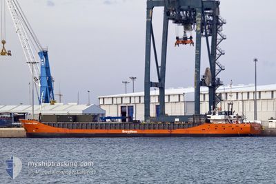
BREADBOX VIPER
General Cargo
Current Trip
| Time Travelled | 17 days |
|---|---|
| Remaining Time | 1 day |
| Distance Travelled | 1043.16 nm |
| Remaining Distance | 201.94 nm |
| AVG Speed | 6.5 Knots |
| MAX Speed | 10 Knots |
| AVG Wind | 15.7 knots |
| MAX Wind | 37 knots |
| MIN Temp | 6.9°C / 44.42°F |
| MAX Temp | 18.3°C / 64.94°F |
| Draught | 3 m |
| Position Received | 6 m ago |
Current Position
| Longitude | --- |
|---|---|
| Latitude | --- |
| Status | Under way using engine |
| Speed | 8.4 Knots |
| Course | 24.8° |
| Area | Aegean Sea |
| Station | T-AIS |
| Position Received | 6 m ago |
Info
Information
The current position of BREADBOX VIPER is in Aegean Sea with coordinates 39.66738° / 25.74335° as reported on 2026-01-09 23:59 by AIS to our vessel tracker app. The vessel's current speed is 8.4 Knots and is heading at the port of DILISKELESI. The estimated time of arrival as calculated by MyShipTracking vessel tracking app is 2026-01-11 03:11 LT
The vessel BREADBOX VIPER (IMO: 9201932, MMSI: 246199000) is a General Cargo that was built in 2000 ( 26 years old ). It's sailing under the flag of [NL] Netherlands.
In this page you can find informations about the vessels current position, last detected port calls, and current voyage information. If the vessels is not in coverage by AIS you will find the latest position.
The current position of BREADBOX VIPER is detected by our AIS receivers and we are not responsible for the reliability of the data. The last position was recorded while the vessel was in Coverage by the Ais receivers of our vessel tracking app.
The current draught of BREADBOX VIPER as reported by AIS is 3 meters
Weather
| Temperature | 15.8°C / 60.44°F |
|---|---|
| Wind Speed | 19 knots |
| Direction | 204° SSW |
| Pressure | 1008 hPa |
| Humidity | 68.5 % |
| Cloud Coverage | 75 % |
Featured Company
Last Trips
| Origin | Departure | Destination | Arrival | Distance | |
|---|---|---|---|---|---|
| 2025-12-15 23:37 | 2025-12-22 19:03 | 948.70 nm | |||
| 2025-12-06 21:33 | 2025-12-13 15:00 | 448.31 nm | |||
| 2025-11-26 18:41 | 2025-12-03 21:32 | 1456.16 nm | |||
| 2025-11-07 18:42 | 2025-11-26 09:26 | 1818.49 nm | |||
| 2025-10-30 14:25 | 2025-11-07 08:58 | 1577.05 nm |
Events
| Time | Event | Details | Position / Dest | Info |
|---|---|---|---|---|
| 2026-01-09 22:39 | Status Changed | Under way using engine Default |
39.49549 / 25.65611
TRDIL
|
Speed: 8.5 kn Course: 28° |
| 2026-01-09 22:37 | Status Changed | Default Under way using engine |
39.49102 / 25.65297
TRDIL
|
Speed: 8.4 kn Course: 28.7° |
| 2026-01-09 22:17 | Draught Changed | 3 3.1 |
39.44999 / 25.62552
TRDIL
|
Speed: 8.4 kn Course: 25.3° |
| 2026-01-09 22:17 | Destination Changed | TRDIL TRTUZ |
39.44999 / 25.62552
TRDIL
|
Speed: 8.4 kn Course: 25.3° |
| 2026-01-09 22:17 | ETA Changed | 2026/01/14 11:00 2026/01/11 11:00 |
39.44999 / 25.62552
TRDIL
|
Speed: 8.4 kn Course: 25.3° |
| 2026-01-09 21:39 | Status Changed | Under way using engine Default |
39.37226 / 25.57326
TRTUZ
|
Speed: 8.4 kn Course: 32° |
| 2026-01-09 21:16 | Status Changed | Default Under way using engine |
39.32499 / 25.53612
TRTUZ
|
Speed: 8.6 kn Course: 30.4° |
| 2026-01-09 21:10 | IN Coverage |
39.31392 / 25.52729
Aegean Sea
TRTUZ
|
Speed: 8.6 kn Course: 30.4° |
|
| 2026-01-09 21:08 | Status Changed | Under way using engine Default |
39.30919 / 25.52371
TRTUZ
|
Speed: 8.5 kn Course: 28° |
| 2026-01-09 19:46 | OUT of Coverage |
39.13356 / 25.41981
Aegean Sea
TRTUZ
|
Speed: 8.6 kn Course: 27.3° |