

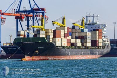
AZARGOUN
Container Ship

Current Trip
| Trip Time | 18 days |
|---|---|
| Trip Distance | 4981.82 nm |
| AVG Speed | 11.3 Knots |
| MAX Speed | 16.8 Knots |
| Draught | 11.8 m |
| AVG Wind | 9.6 knots |
| MAX Wind | 25 knots |
| MIN Temp | 16.6°C / 61.88°F |
| MAX Temp | 29.3°C / 84.74°F |
| Position Received | 9 d ago |
Current Position
| Longitude | --- |
|---|---|
| Latitude | --- |
| Status | Under way using engine |
| Speed | 11 Knots |
| Course | 294° |
| Area | Laccadive Sea |
| Station | T-AIS |
| Position Received | 9 d ago |
Information
The current position of AZARGOUN is in Laccadive Sea with coordinates 7.21399° / 77.00539° as reported on 2025-02-15 23:41 by AIS to our vessel tracker app. The vessel's current speed is 11 Knots and is currently inside the port of RAJAEI.
The vessel AZARGOUN (IMO: 9283019, MMSI: 422039300) is a Container Ship that was built in 2003 ( 22 years old ). It's sailing under the flag of [IR] Iran.
In this page you can find informations about the vessels current position, last detected port calls, and current voyage information. If the vessels is not in coverage by AIS you will find the latest position.
The current position of AZARGOUN is detected by our AIS receivers and we are not responsible for the reliability of the data. The last position was recorded while the vessel was in Coverage by the Ais receivers of our vessel tracking app.
The current draught of AZARGOUN as reported by AIS is 11.8 meters
Weather
| Temperature | 23°C / 73.4°F |
|---|---|
| Wind Speed | 15 knots |
| Direction | 242° WSW |
| Pressure | 1015.6 hPa |
| Humidity | 63.3 % |
| Cloud Coverage | 10 % |


Featured Company
Last Port Calls
| Port | Arrival | Departure | Time In Port |
|---|---|---|---|
| 2025-02-23 13:56 | |||
| 2025-02-03 05:01 | 2025-02-05 02:01 | 1 d | |
| 2025-01-13 21:48 | 2025-01-14 19:00 | 21 h | |
| 2025-01-03 04:21 | 2025-01-03 13:22 | 9 h | |
| 2024-12-26 09:30 | 2024-12-31 08:13 | 4 d | |
| 2024-12-14 04:56 | 2024-12-14 14:08 | 9 h | |
| 2024-12-03 07:35 | 2024-12-03 18:38 | 11 h | |
| 2024-12-01 19:13 |
Last Trips
| Origin | Departure | Destination | Arrival | Distance | |
|---|---|---|---|---|---|
| 2025-02-05 10:01 | 2025-02-23 17:26 | 4981.82 nm | |||
| 2025-01-14 22:30 | 2025-02-03 13:01 | 5027.98 nm | |||
| 2024-12-31 10:13 | 2025-01-14 01:18 | 3621.83 nm | |||
| 2024-12-31 10:13 | 2025-01-03 06:21 | 694.15 nm | |||
| 2024-12-03 22:38 | 2024-12-26 11:30 | 3767.83 nm | |||
| 2024-12-03 22:38 | 2024-12-14 06:56 | 2972.71 nm | |||
| 2024-12-01 22:43 | 2024-12-03 11:35 | 202.99 nm |
Events
| Time | Event | Details | Position / Dest | Info |
|---|---|---|---|---|
| 2025-02-23 14:04 | STOP Moving |
27.09627 / 56.04993
[IR] RAJAEI
|
Speed: 0.1 kn Course: 153° |
|
| 2025-02-23 13:56 | PORT ARRIVAL |
|
27.09615 / 56.04931
[IR] RAJAEI
|
Speed: 1.7 kn Course: 102° |
| 2025-02-23 12:03 | START Moving | 5.43 nm, South of SHAHID BAHONAR |
27.04322 / 56.21215
IR/BND
|
Speed: 3.9 kn Course: 330° |
| 2025-02-22 20:29 | STOP Moving | 5.23 nm, North West of QUESHM |
27.04192 / 56.21738
IR/BND
|
Speed: Course: 246° |
| 2025-02-22 07:25 | START Moving | 4.51 nm, East of JASK |
25.62945 / 57.84801
IR/BND
|
Speed: 4 kn Course: 319° |
| 2025-02-22 05:04 | STOP Moving | 5.74 nm, East of JASK |
25.62068 / 57.86886
IR/BND
|
Speed: 0.2 kn Course: 58° |
| 2025-02-22 03:37 | START Moving | 13.55 nm, South East of JASK |
25.45117 / 57.88994
IR/BND
|
Speed: 4.5 kn Course: 348° |
| 2025-02-22 03:13 | STOP Moving | 13.83 nm, South East of JASK |
25.44730 / 57.89297
IR/BND
|
Speed: 0.3 kn Course: 351° |
| 2025-02-15 23:58 | Status Changed | Default Under way using engine |
7.23591 / 76.95626
IR/BND
|
Speed: 11 kn Course: 294° |
| 2025-02-15 23:41 | OUT of Coverage |
7.21399 / 77.00539
Laccadive Sea
IR/BND
|
Speed: 11 kn Course: 294° |