
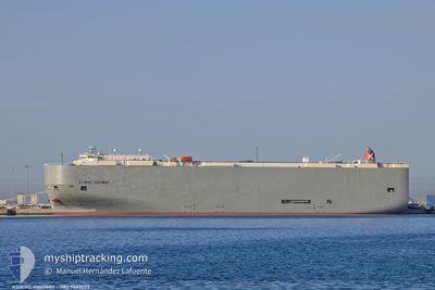
ATHENS HIGHWAY
Vehicles Carrier
Current Trip
| Time Travelled | 4 days |
|---|---|
| Remaining Time | --- |
| Distance Travelled | 1558.12 nm |
| Remaining Distance | --- |
| AVG Speed | 15.8 Knots |
| MAX Speed | 18.2 Knots |
| AVG Wind | 14.1 knots |
| MAX Wind | 24.1 knots |
| MIN Temp | 10.3°C / 50.54°F |
| MAX Temp | 20.5°C / 68.9°F |
| Draught | 9.7 m |
| Position Received | 4 m ago |
Current Position
| Longitude | -18.69735° |
|---|---|
| Latitude | 23.48528° |
| Status | Under way using engine |
| Speed | 16.1 Knots |
| Course | 205° |
| Area | North Atlantic Ocean |
| Station | T-AIS |
| Position Received | 4 m ago |
Info
Information
The current position of ATHENS HIGHWAY is in North Atlantic Ocean with coordinates 23.48528° / -18.69735° as reported on 2024-05-03 21:43 by AIS to our vessel tracker app. The vessel's current speed is 16.1 Knots and is heading at the port of SINGAPORE. The estimated time of arrival as calculated by MyShipTracking vessel tracking app is 2024-05-30 22:00 LT
The vessel ATHENS HIGHWAY (IMO: 9443073, MMSI: 432930000) is a Vehicles Carrier that was built in 2008 ( 16 years old ). It's sailing under the flag of [JP] Japan.
In this page you can find informations about the vessels current position, last detected port calls, and current voyage information. If the vessels is not in coverage by AIS you will find the latest position.
The current position of ATHENS HIGHWAY is detected by our AIS receivers and we are not responsible for the reliability of the data. The last position was recorded while the vessel was in Coverage by the Ais receivers of our vessel tracking app.
The current draught of ATHENS HIGHWAY as reported by AIS is 9.7 meters
Weather
| Temperature | 20.1°C / 68.18°F |
|---|---|
| Wind Speed | 18 knots |
| Direction | 28° NNE |
| Pressure | 1016.6 hPa |
| Humidity | 84.2 % |
| Cloud Coverage | --- |
Featured Company
Last Port Calls
| Port | Arrival | Departure | Time In Port |
|---|---|---|---|
| 2024-04-29 09:46 | 2024-04-29 21:15 | 11 h | |
| 2024-04-23 08:31 | 2024-04-25 00:30 | 1 d | |
| 2024-04-20 15:00 | 2024-04-22 11:02 | 1 d | |
| 2024-04-18 03:30 | 2024-04-18 12:25 | 8 h | |
| 2024-04-12 03:39 | 2024-04-13 12:26 | 1 d | |
| 2024-03-04 11:03 | 2024-03-05 06:49 | 19 h | |
| 2024-03-01 21:07 | 2024-03-04 07:51 | 2 d |
Last Trips
| Origin | Departure | Destination | Arrival | Distance | |
|---|---|---|---|---|---|
| 2024-04-25 02:30 | 2024-04-29 11:46 | 1091.62 nm | |||
| 2024-04-22 13:02 | 2024-04-23 10:31 | 312.13 nm | |||
| 2024-04-18 13:25 | 2024-04-20 17:00 | 642.35 nm | |||
| 2024-04-13 14:26 | 2024-04-18 04:30 | 1725.40 nm | |||
| 2024-03-05 15:49 | 2024-04-12 05:39 | 14314.33 nm | |||
| 2024-03-04 16:51 | 2024-03-04 20:03 | 47.07 nm | |||
| 2024-02-29 17:33 | 2024-03-02 06:07 | 276.32 nm |
Events
| Time | Event | Details | Position / Dest | Info |
|---|---|---|---|---|
| 2024-05-03 21:43 | Status Changed | Under way using engine Default |
23.48528 / -18.69735
SGSIN
|
Speed: 16 kn Course: 203° |
| 2024-05-03 21:43 | IN Coverage |
23.48528 / -18.69735
North Atlantic Ocean
SGSIN
|
Speed: 16.1 kn Course: 205° |
|
| 2024-05-03 19:19 | Status Changed | Default Under way using engine |
24.07142 / -18.40203
SGSIN
|
Speed: 16 kn Course: 206° |
| 2024-05-03 19:15 | OUT of Coverage |
24.08713 / -18.39353
North Atlantic Ocean
SGSIN
|
Speed: 16 kn Course: 206° |
|
| 2024-05-03 19:09 | Status Changed | Under way using engine Default |
24.10812 / -18.38227
SGSIN
|
Speed: 15.9 kn Course: 207° |
| 2024-05-03 19:09 | IN Coverage |
24.10332 / -18.38482
North Atlantic Ocean
SGSIN
|
Speed: 16 kn Course: 206° |
|
| 2024-05-03 18:06 | Status Changed | Default Under way using engine |
24.36663 / -18.24753
SGSIN
|
Speed: 16.3 kn Course: 204° |
| 2024-05-03 18:00 | OUT of Coverage |
24.39148 / -18.23523
North Atlantic Ocean
SGSIN
|
Speed: 16.3 kn Course: 204° |
|
| 2024-05-03 17:54 | Status Changed | Under way using engine Default |
24.41620 / -18.22295
SGSIN
|
Speed: 16.2 kn Course: 205° |
| 2024-05-03 17:37 | Status Changed | Default Under way using engine |
24.48442 / -18.18850
SGSIN
|
Speed: 16.4 kn Course: 206° |