

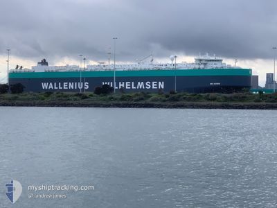
ARC HONOR
Vehicles Carrier

Current Trip
| Time Travelled | 2 days |
|---|---|
| Remaining Time | --- |
| Distance Travelled | 877.55 nm |
| Remaining Distance | --- |
| AVG Speed | 14.9 Knots |
| MAX Speed | 19.4 Knots |
| AVG Wind | 16.7 knots |
| MAX Wind | 31 knots |
| MIN Temp | 8.3°C / 46.94°F |
| MAX Temp | 13.1°C / 55.58°F |
| Draught | 10.9 m |
| Position Received | 9 h, 52 m ago |
Current Position
| Longitude | --- |
|---|---|
| Latitude | --- |
| Status | Under way using engine |
| Speed | 16.9 Knots |
| Course | 201.1° |
| Area | North Atlantic Ocean |
| Station | T-AIS |
| Position Received | 9 h, 52 m ago |
Information
The current position of ARC HONOR is in North Atlantic Ocean with coordinates 38.49013° / -10.12802° as reported on 2025-03-21 21:03 by AIS to our vessel tracker app. The vessel's current speed is 16.9 Knots and is heading at the port of BALTIMORE. The estimated time of arrival as calculated by MyShipTracking vessel tracking app is 2025-03-28 20:00 LT
The vessel ARC HONOR (IMO: 9505089, MMSI: 303530000) is a Vehicles Carrier that was built in 2012 ( 13 years old ). It's sailing under the flag of [US] USA.
In this page you can find informations about the vessels current position, last detected port calls, and current voyage information. If the vessels is not in coverage by AIS you will find the latest position.
The current position of ARC HONOR is detected by our AIS receivers and we are not responsible for the reliability of the data. The last position was recorded while the vessel was in Coverage by the Ais receivers of our vessel tracking app.
The current draught of ARC HONOR as reported by AIS is 10.9 meters
Weather
| Temperature | 12.9°C / 55.22°F |
|---|---|
| Wind Speed | 30 knots |
| Direction | 293° WNW |
| Pressure | 1014.2 hPa |
| Humidity | 61.9 % |
| Cloud Coverage | 32 % |


Featured Company
Last Port Calls
| Port | Arrival | Departure | Time In Port |
|---|---|---|---|
| 2025-03-18 09:05 | 2025-03-19 09:15 | 1 d | |
| 2025-03-15 02:00 | 2025-03-16 15:37 | 1 d | |
| 2025-03-12 00:52 | 2025-03-14 02:31 | 2 d | |
| 2025-03-08 23:35 | 2025-03-11 02:21 | 2 d | |
| 2025-02-26 17:27 | 2025-02-27 10:21 | 16 h | |
| 2025-02-25 16:38 | 2025-02-26 01:11 | 8 h | |
| 2025-02-23 03:34 | 2025-02-24 20:08 | 1 d | |
| 2025-02-19 21:25 | 2025-02-22 17:43 | 2 d | |
| 2025-02-16 22:45 | 2025-02-17 23:51 | 1 d | |
| 2025-02-11 21:01 | 2025-02-12 17:01 | 20 h |
Most Visited Ports (Last year)
| Port | Arrivals | |
|---|---|---|
| 5 | ||
| 3 | ||
| 3 | ||
| 3 | ||
| 3 | ||
| 2 |
Last Trips
| Origin | Departure | Destination | Arrival | Distance | |
|---|---|---|---|---|---|
| 2025-03-16 15:37 | 2025-03-18 09:05 | 708.60 nm | |||
| 2025-03-14 02:31 | 2025-03-15 02:00 | 375.72 nm | |||
| 2025-03-11 02:21 | 2025-03-12 00:52 | 322.47 nm | |||
| 2025-02-27 10:21 | 2025-03-08 23:35 | 3268.53 nm | |||
| 2025-02-26 01:11 | 2025-02-26 17:27 | 236.52 nm | |||
| 2025-02-24 20:08 | 2025-02-25 16:38 | 257.11 nm | |||
| 2025-02-22 17:43 | 2025-02-23 03:34 | 159.62 nm | |||
| 2025-02-17 23:51 | 2025-02-19 21:25 | 661.05 nm | |||
| 2025-02-12 17:01 | 2025-02-16 22:45 | 1493.40 nm | |||
| 2025-01-20 16:32 | 2025-02-11 21:01 | 7820.21 nm |
Events
| Time | Event | Details | Position / Dest | Info |
|---|---|---|---|---|
| 2025-03-21 21:03 | OUT of Coverage |
38.49013 / -10.12802
North Atlantic Ocean
US BAL
|
Speed: 16.9 kn Course: 201.1° |
|
| 2025-03-21 18:33 | Change Sea Area | Portuguese part of the North Atlantic Ocean French part of the English Channel |
39.18394 / -10.07469
North Atlantic Ocean
US BAL
|
Speed: 16 kn Course: 184.7° |
| 2025-03-21 18:32 | IN Coverage |
39.18394 / -10.07469
North Atlantic Ocean
US BAL
|
Speed: 16 kn Course: 184.7° |
|
| 2025-03-19 20:09 | OUT of Coverage |
49.41181 / -4.40365
English Channel
US BAL
|
Speed: 15.9 kn Course: 240.2° |
|
| 2025-03-19 19:16 | Change Sea Area | French part of the English Channel United Kingdom part of the English Channel |
49.52670 / -4.09189
English Channel
US BAL
|
Speed: 16.1 kn Course: 240.3° |
| 2025-03-19 16:34 | Change Sea Area | United Kingdom part of the English Channel Guernsey part of the English Channel |
49.93478 / -3.06052
English Channel
US BAL
|
Speed: 18.8 kn Course: 239.6° |
| 2025-03-19 15:56 | Change Sea Area | Guernsey part of the English Channel United Kingdom part of the English Channel |
49.99152 / -2.76301
English Channel
US BAL
|
Speed: 19.3 kn Course: 256.1° |
| 2025-03-19 15:55 | IN Coverage |
49.99152 / -2.76301
English Channel
US BAL
|
Speed: 19.3 kn Course: 256.1° |
|
| 2025-03-19 14:16 | OUT of Coverage |
50.20936 / -2.01639
English Channel
US BAL
|
Speed: 18.1 kn Course: 243.7° |
|
| 2025-03-19 09:15 | PORT DEPARTURE |
|
50.86923 / -1.37676
US BAL
|
Speed: 10.4 kn Course: 130° |