
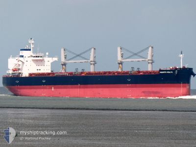
AQUAVITA WEALTH
Cargo
Current Trip
| Time Travelled | 12 h, 39 mins |
|---|---|
| Remaining Time | 3 days |
| Distance Travelled | 129.21 nm |
| Remaining Distance | 857.79 nm |
| AVG Speed | 10.2 Knots |
| MAX Speed | 12.8 Knots |
| AVG Wind | 14.5 knots |
| MAX Wind | 24 knots |
| MIN Temp | 8.2°C / 46.76°F |
| MAX Temp | 10.7°C / 51.26°F |
| Draught | 6.1 m |
| Position Received | 11 h, 6 m ago |
Current Position
| Longitude | --- |
|---|---|
| Latitude | --- |
| Status | Moored |
| Speed | 8.7 Knots |
| Course | 322.8° |
| Area | Baltic Sea |
| Station | T-AIS |
| Position Received | 11 h, 6 m ago |
Info
Information
The current position of AQUAVITA WEALTH is in Baltic Sea with coordinates 53.66270° / 14.53440° as reported on 2025-12-10 16:48 by AIS to our vessel tracker app. The vessel's current speed is 8.7 Knots and is heading at the port of DUNKERQUE. The estimated time of arrival as calculated by MyShipTracking vessel tracking app is 2025-12-14 16:06 LT
The vessel AQUAVITA WEALTH (IMO: 9985784, MMSI: 538010807) is a Cargo It's sailing under the flag of [MH] Marshall Is.
In this page you can find informations about the vessels current position, last detected port calls, and current voyage information. If the vessels is not in coverage by AIS you will find the latest position.
The current position of AQUAVITA WEALTH is detected by our AIS receivers and we are not responsible for the reliability of the data. The last position was recorded while the vessel was in Coverage by the Ais receivers of our vessel tracking app.
The current draught of AQUAVITA WEALTH as reported by AIS is 6.1 meters
Weather
| Temperature | 8.4°C / 47.12°F |
|---|---|
| Wind Speed | 22 knots |
| Direction | 256° WSW |
| Pressure | 1016 hPa |
| Humidity | 87.7 % |
| Cloud Coverage | 48 % |
Featured Company
Last Port Calls
| Port | Arrival | Departure | Time In Port |
|---|---|---|---|
| 2025-12-02 07:32 | 2025-12-10 16:16 | 8 d | |
| 2025-11-27 00:06 | 2025-11-28 01:06 | 1 d | |
| 2025-11-16 09:48 | 2025-11-18 11:37 | 2 d | |
| 2025-10-26 21:00 | 2025-10-29 07:46 | 2 d | |
| 2025-10-05 14:35 | 2025-10-08 22:24 | 3 d |
Most Visited Ports (Last year)
| Port | Arrivals | |
|---|---|---|
| 3 | ||
| 2 | ||
| 2 | ||
| 1 | ||
| 1 | ||
| 1 |
Last Trips
| Origin | Departure | Destination | Arrival | Distance | |
|---|---|---|---|---|---|
| 2025-11-28 01:06 | 2025-12-02 07:32 | 658.04 nm | |||
| 2025-11-18 11:37 | 2025-11-27 00:06 | 2349.17 nm | |||
| 2025-10-29 07:46 | 2025-11-16 09:48 | 4238.57 nm | |||
| 2025-10-08 22:24 | 2025-10-26 21:00 | 432.83 nm | |||
| 2025-09-29 13:14 | 2025-10-05 14:35 | 1776.93 nm |
Events
| Time | Event | Details | Position / Dest | Info |
|---|---|---|---|---|
| 2025-12-10 16:56 | Status Changed | Default Moored |
53.67707 / 14.51516
FRDKK
|
Speed: 8.7 kn Course: 322.8° |
| 2025-12-10 16:48 | OUT of Coverage |
53.66270 / 14.53440
Baltic Sea
FRDKK
|
Speed: 8.7 kn Course: 322.8° |
|
| 2025-12-10 15:16 | PORT DEPARTURE |
|
53.46505 / 14.60136
FRDKK
|
Speed: 6 kn Course: 19° |
| 2025-12-10 14:44 | START Moving |
53.40664 / 14.60783
[PL] SZCZECIN
|
Speed: 3.1 kn Course: 18° |
|
| 2025-12-10 12:26 | Status Changed | Moored Default |
53.40818 / 14.59988
[PL] SZCZECIN
|
Speed: Course: 286° |
| 2025-12-10 12:23 | Status Changed | Default Moored |
53.40819 / 14.59987
[PL] SZCZECIN
|
Speed: Course: 286° |
| 2025-12-10 12:02 | Status Changed | Moored Default |
53.40818 / 14.59992
[PL] SZCZECIN
|
Speed: Course: 286° |
| 2025-12-10 11:59 | Status Changed | Default Moored |
53.40816 / 14.59987
[PL] SZCZECIN
|
Speed: Course: 286° |
| 2025-12-10 11:47 | Status Changed | Moored Default |
53.40821 / 14.59987
[PL] SZCZECIN
|
Speed: Course: 286° |
| 2025-12-10 11:44 | Status Changed | Default Moored |
53.40820 / 14.59986
[PL] SZCZECIN
|
Speed: Course: 285° |