
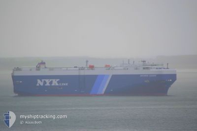
ANTARES LEADER
Vehicles Carrier
Current Trip
| Trip Time | 9 days |
|---|---|
| Trip Distance | 2732.95 nm |
| AVG Speed | 13.4 Knots |
| MAX Speed | 13.4 Knots |
| Draught | 9.3 m |
| AVG Wind | 9.9 knots |
| MAX Wind | 22 knots |
| MIN Temp | 24.8°C / 76.64°F |
| MAX Temp | 30.4°C / 86.72°F |
| Position Received | 5 h, 23 m ago |
Current Position
| Longitude | -66.14632° |
|---|---|
| Latitude | 18.56536° |
| Status | Under way using engine |
| Speed | 9.3 Knots |
| Course | 142.5° |
| Area | North Atlantic Ocean |
| Station | T-AIS |
| Position Received | 5 h, 23 m ago |
Info
Information
The current position of ANTARES LEADER is in North Atlantic Ocean with coordinates 18.56536° / -66.14632° as reported on 2024-05-22 12:29 by AIS to our vessel tracker app. The vessel's current speed is 9.3 Knots and is currently inside the port of SAN JUAN.
The vessel ANTARES LEADER (IMO: 9539169, MMSI: 431761000) is a Vehicles Carrier that was built in 2011 ( 13 years old ). It's sailing under the flag of [JP] Japan.
In this page you can find informations about the vessels current position, last detected port calls, and current voyage information. If the vessels is not in coverage by AIS you will find the latest position.
The current position of ANTARES LEADER is detected by our AIS receivers and we are not responsible for the reliability of the data. The last position was recorded while the vessel was in Coverage by the Ais receivers of our vessel tracking app.
The current draught of ANTARES LEADER as reported by AIS is 9.3 meters
Weather
| Temperature | 26.8°C / 80.24°F |
|---|---|
| Wind Speed | 3 knots |
| Direction | 275° W |
| Pressure | 1015.2 hPa |
| Humidity | 82.6 % |
| Cloud Coverage | 100 % |
Featured Company
Last Port Calls
| Port | Arrival | Departure | Time In Port |
|---|---|---|---|
| 2024-05-22 13:09 | |||
| 2024-05-12 03:18 | 2024-05-12 23:30 | 20 h | |
| 2024-04-23 03:15 | 2024-04-23 09:00 | 5 h | |
| 2024-04-21 05:18 | 2024-04-22 03:20 | 22 h | |
| 2024-04-17 21:45 | |||
| 2024-04-16 04:59 | 2024-04-17 14:37 | 1 d | |
| 2024-04-13 21:09 | 2024-04-14 10:26 | 13 h | |
| 2024-03-30 06:40 | 2024-03-30 20:11 | 13 h | |
| 2024-03-26 04:46 | 2024-03-27 03:32 | 22 h | |
| 2024-03-23 16:52 | 2024-03-24 01:29 | 8 h |
Last Trips
| Origin | Departure | Destination | Arrival | Distance | |
|---|---|---|---|---|---|
| 2024-05-12 18:30 | 2024-05-22 09:09 | 2732.95 nm | |||
| 2024-04-23 18:00 | 2024-05-11 22:18 | 6287.02 nm | |||
| 2024-04-22 12:20 | 2024-04-23 12:15 | 248.50 nm | |||
| 2024-04-17 23:37 | 2024-04-18 06:45 | 94.69 nm | |||
| 2024-04-14 19:26 | 2024-04-16 13:59 | 462.79 nm | |||
| 2024-03-31 01:41 | 2024-04-14 06:09 | 4712.93 nm | |||
| 2024-03-27 09:02 | 2024-03-30 12:10 | 1310.51 nm | |||
| 2024-03-24 06:59 | 2024-03-26 10:16 | 325.71 nm | |||
| 2024-03-22 19:39 | 2024-03-23 22:22 | 420.23 nm | |||
| 2024-03-04 03:00 | 2024-03-14 14:14 | 3598.73 nm |
Events
| Time | Event | Details | Position / Dest | Info |
|---|---|---|---|---|
| 2024-05-22 13:39 | STOP Moving |
18.44051 / -66.08720
[PR] SAN JUAN
|
Speed: 0.1 kn Course: 75° |
|
| 2024-05-22 13:09 | PORT ARRIVAL |
|
18.47167 / -66.12833
[PR] SAN JUAN
|
Speed: 10.8 kn Course: 183° |
| 2024-05-22 12:33 | Status Changed | Default Under way using engine |
18.55500 / -66.13834
MX LZC
|
Speed: 9.3 kn Course: 142.5° |
| 2024-05-22 12:29 | OUT of Coverage |
18.56536 / -66.14632
North Atlantic Ocean
[PR] SAN JUAN
|
Speed: 9.3 kn Course: 142.5° |
|
| 2024-05-22 12:20 | Change Sea Area | Puerto Rican part of the North Atlantic Ocean Mexican part of the North Pacific Ocean |
18.58187 / -66.15911
North Atlantic Ocean
|
Speed: 6.6 kn Course: 147.5° |
| 2024-05-22 12:19 | Status Changed | Under way using engine Default |
18.58237 / -66.15944
MX LZC
|
Speed: 7 kn Course: 147° |
| 2024-05-22 12:06 | IN Coverage |
18.58187 / -66.15911
North Atlantic Ocean
|
Speed: 6.6 kn Course: 147.5° |
|
| 2024-05-19 16:22 | START Moving | 3.69 nm, South of CRISTOBAL |
9.28564 / -79.92129
MX LZC
|
Speed: 4.6 kn Course: 10° |
| 2024-05-19 14:31 | STOP Moving | 4.82 nm, South of CRISTOBAL |
9.26692 / -79.92398
MX LZC
|
Speed: Course: 8° |
| 2024-05-19 11:06 | START Moving | 4.66 nm, North West of RODMAN |
9.02078 / -79.61655
MX LZC
|
Speed: 4 kn Course: 311° |