
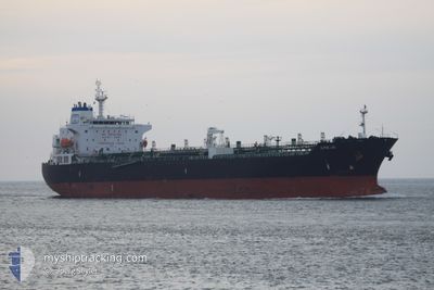
ALPINE LINK
Oil/Chemical Tanker
Current Trip
| Time Travelled | 2 days |
|---|---|
| Remaining Time | --- |
| Distance Travelled | 203.89 nm |
| Remaining Distance | 3.88 nm |
| AVG Speed | 10.1 Knots |
| MAX Speed | 12.3 Knots |
| AVG Wind | 19.8 knots |
| MAX Wind | 27 knots |
| MIN Temp | 18.8°C / 65.84°F |
| MAX Temp | 28.3°C / 82.94°F |
| Draught | 8.3 m |
| Position Received | 1 d ago |
Current Position
| Longitude | 4.98984° |
|---|---|
| Latitude | 43.34465° |
| Status | Under way using engine |
| Speed | 8.8 Knots |
| Course | 336° |
| Area | Mediterranean Sea - Western Basin |
| Station | T-AIS |
| Position Received | 1 d ago |
Info
Information
The current position of ALPINE LINK is in Mediterranean Sea - Western Basin with coordinates 43.34465° / 4.98984° as reported on 2024-07-01 16:00 by AIS to our vessel tracker app. The vessel's current speed is 8.8 Knots and is heading at the port of PORT DE BOUC. The estimated time of arrival as calculated by MyShipTracking vessel tracking app is 2024-07-01 16:00 LT
The vessel ALPINE LINK (IMO: 9478614, MMSI: 538003758) is a Oil/Chemical Tanker that was built in 2010 ( 14 years old ). It's sailing under the flag of [MH] Marshall Is.
In this page you can find informations about the vessels current position, last detected port calls, and current voyage information. If the vessels is not in coverage by AIS you will find the latest position.
The current position of ALPINE LINK is detected by our AIS receivers and we are not responsible for the reliability of the data. The last position was recorded while the vessel was in Coverage by the Ais receivers of our vessel tracking app.
The current draught of ALPINE LINK as reported by AIS is 8.3 meters
Weather
| Temperature | 19°C / 66.2°F |
|---|---|
| Wind Speed | 23 knots |
| Direction | 326° NW |
| Pressure | 1010.5 hPa |
| Humidity | 59.9 % |
| Cloud Coverage | 62 % |
Featured Company
Events
| Time | Event | Details | Position / Dest | Info |
|---|---|---|---|---|
| 2024-07-01 16:26 | STOP Moving | 1.11 nm, South West of PORT DE BOUC |
43.38967 / 4.96061
FR PDB
|
Speed: 0.3 kn Course: 9° |
| 2024-07-01 16:06 | Status Changed | Default Under way using engine |
43.35777 / 4.97993
FR PDB
|
Speed: 8.8 kn Course: 336° |
| 2024-07-01 16:00 | OUT of Coverage |
43.34465 / 4.98984
Mediterranean Sea - Western Basin
FR PDB
|
Speed: 8.8 kn Course: 336° |
|
| 2024-07-01 15:33 | Status Changed | Under way using engine Default |
43.30414 / 4.99810
FR PDB
|
Speed: 4 kn Course: 345° |
| 2024-07-01 15:18 | Status Changed | Default Under way using engine |
43.27513 / 5.01073
FR PDB
|
Speed: 10.9 kn Course: 344.5° |
| 2024-07-01 14:16 | Status Changed | Under way using engine Default |
43.08430 / 5.06696
FR PDB
|
Speed: 12 kn Course: 44° |
| 2024-07-01 14:14 | Status Changed | Default Under way using engine |
43.07821 / 5.05987
FR PDB
|
Speed: 12 kn Course: 44.1° |
| 2024-07-01 13:49 | Status Changed | Under way using engine Default |
43.01926 / 4.98245
FR PDB
|
Speed: 11.8 kn Course: 44° |
| 2024-07-01 13:38 | Status Changed | Default Under way using engine |
42.99217 / 4.94663
FR PDB
|
Speed: 11.6 kn Course: 44.2° |
| 2024-07-01 13:23 | Detected in Sea | French part of the Mediterranean Sea - Western Basin |
42.95626 / 4.90044
Mediterranean Sea - Western Basin
FR PDB
|
Speed: 11.6 kn Course: 43.2° |