
ALFRED
Tanker
Current Trip
| Time Travelled | 34 days |
|---|---|
| Remaining Time | --- |
| Distance Travelled | 5724.34 nm |
| Remaining Distance | 18.23 nm |
| AVG Speed | 9.9 Knots |
| MAX Speed | 15.1 Knots |
| AVG Wind | 11.4 knots |
| MAX Wind | 28.4 knots |
| MIN Temp | 2.2°C / 35.96°F |
| MAX Temp | 21.7°C / 71.06°F |
| Draught | 9 m |
| Position Received | Now |
Current Position
| Longitude | 37.59879° |
|---|---|
| Latitude | 44.48995° |
| Status | Under way using engine |
| Speed | 1.8 Knots |
| Course | 180° |
| Area | Black Sea |
| Station | T-AIS |
| Position Received | Now |
Info
Information
The current position of ALFRED is in Black Sea with coordinates 44.48995° / 37.59879° as reported on 2024-05-15 19:26 by AIS to our vessel tracker app. The vessel's current speed is 1.8 Knots and is heading at the port of NOVOROSSIYSK. The estimated time of arrival as calculated by MyShipTracking vessel tracking app is 2024-05-15 16:00 LT
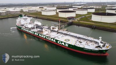
The vessel ALFRED (IMO: 9826897, MMSI: 636018830) is a Tanker It's sailing under the flag of [LR] Liberia.
In this page you can find informations about the vessels current position, last detected port calls, and current voyage information. If the vessels is not in coverage by AIS you will find the latest position.
The current position of ALFRED is detected by our AIS receivers and we are not responsible for the reliability of the data. The last position was recorded while the vessel was in Coverage by the Ais receivers of our vessel tracking app.
The current draught of ALFRED as reported by AIS is 9 meters
Weather
| Temperature | 13.2°C / 55.76°F |
|---|---|
| Wind Speed | 8 knots |
| Direction | 216° SW |
| Pressure | 1019.2 hPa |
| Humidity | 70 % |
| Cloud Coverage | 11 % |
Featured Company
Most Visited Ports (Last year)
| Port | Arrivals | |
|---|---|---|
| 3 | ||
| 2 | ||
| 2 | ||
| 2 | ||
| 2 | ||
| 1 |
Last Trips
| Origin | Departure | Destination | Arrival | Distance | |
|---|---|---|---|---|---|
| 2024-03-08 08:30 | 2024-04-10 05:58 | 6380.14 nm | |||
| 2024-02-20 02:35 | 2024-03-08 08:31 | 1707.90 nm |
Events
| Time | Event | Details | Position / Dest | Info |
|---|---|---|---|---|
| 2024-05-15 18:47 | START Moving | 16.51 nm, South West of NOVOROSSIYSK |
44.47842 / 37.60974
RU NVS
|
Speed: 3.1 kn Course: 20° |
| 2024-05-15 18:38 | STOP Moving | 16.72 nm, South West of NOVOROSSIYSK |
44.47436 / 37.60973
RU NVS
|
Speed: 0.3 kn Course: 13° |
| 2024-05-15 18:28 | Status Changed | Under way using engine Default |
44.46870 / 37.60861
RU NVS
|
Speed: 3.2 kn Course: 23° |
| 2024-05-15 18:22 | Status Changed | Default Under way using engine |
44.46471 / 37.60678
RU NVS
|
Speed: 1.5 kn Course: 26° |
| 2024-05-15 16:45 | ETA Changed | 2024/05/15 16:00 2024/05/13 19:00 |
44.36092 / 37.37925
RU NVS
|
Speed: 8.8 kn Course: 56.2° |
| 2024-05-15 16:06 | Status Changed | Under way using engine Default |
44.32165 / 37.26377
RU NVS
|
Speed: 8.7 kn Course: 62° |
| 2024-05-15 16:04 | Status Changed | Default Under way using engine |
44.31914 / 37.25729
RU NVS
|
Speed: 8.8 kn Course: 58.9° |
| 2024-05-15 15:36 | Detected in Sea | Russian part of the Black Sea |
44.28383 / 37.17565
Black Sea
|
Speed: 8.7 kn Course: 60.5° |
| 2024-05-15 15:36 | Status Changed | Under way using engine Default |
44.28383 / 37.17565
RU NVS
|
Speed: 8.7 kn Course: 63° |
| 2024-05-15 15:20 | IN Coverage |
44.28383 / 37.17565
Black Sea
|
Speed: 8.7 kn Course: 60.5° |