
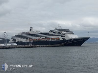
ZAANDAM
Passengers Ship
Current Trip
| Time Travelled | 1 day |
|---|---|
| Remaining Time | 2 h, 54 mins |
| Distance Travelled | 475.19 nm |
| Remaining Distance | 62.26 nm |
| AVG Speed | 14.9 Knop |
| MAX Speed | 20.4 Knop |
| AVG Wind | 6.7 knots |
| MAX Wind | 14.7 knots |
| MIN Temp | 3.1°C / 37.58°F |
| MAX Temp | 10°C / 50°F |
| Djupgående | 8 m |
| Position mottagen | Nu |
Current Position
| Longitud | -124.52252° |
|---|---|
| Latitude | 49.52180° |
| Status | Under way using engine |
| Fart | 20.1 Knop |
| Kurs | 138.4° |
| Område | The Coastal Waters of Southeast Alaska and British Columbia |
| Station | T-AIS |
| Position mottagen | Nu |
Info
Information
The current position of ZAANDAM is in The Coastal Waters of Southeast Alaska and British Columbia with coordinates 49.52180° / -124.52252° as reported on 2024-05-08 10:20 by AIS to our vessel tracker app. The vessel's current speed is 20.1 Knop and is heading at the port of VANCOUVER. The estimated time of arrival as calculated by MyShipTracking vessel tracking app is 2024-05-08 13:14 LT
The vessel ZAANDAM (IMO: 9156527, MMSI: 246442000) is a Passengers Ship that was built in 2000 ( 24 År gammal ). It's sailing under the flag of [NL] Netherlands.
In this page you can find informations about the vessels current position, last detected port calls, and current voyage information. If the vessels is not in coverage by AIS you will find the latest position.
The current position of ZAANDAM is detected by our AIS receivers and we are not responsible for the reliability of the data. The last position was recorded while the vessel was in Coverage by the Ais receivers of our vessel tracking app.
The current draught of ZAANDAM as reported by AIS is 8 meters
Weather
| Temperature | 9.4°C / 48.92°F |
|---|---|
| Wind Speed | 6 knots |
| Direction | 291° WNW |
| Pressure | 1027.8 hPa |
| Humidity | 73.4 % |
| Cloud Coverage | 11 % |
Featured Company
Last Port Calls
| Port | Arrival | Departure | Time In Port |
|---|---|---|---|
| 2024-05-06 18:38 | 2024-05-07 03:34 | 8 h | |
| 2024-05-04 13:52 | 2024-05-05 05:10 | 15 h | |
| 2024-05-03 20:47 | 2024-05-04 06:02 | 9 h | |
| 2024-05-01 13:07 | 2024-05-01 23:36 | 10 h | |
| 2024-04-30 12:57 | 2024-05-01 01:08 | 12 h | |
| 2024-04-28 16:51 | 2024-04-29 01:55 | 9 h | |
| 2024-04-27 13:26 | 2024-04-27 22:54 | 9 h | |
| 2024-04-26 20:08 | 2024-04-27 06:10 | 10 h | |
| 2024-04-23 14:06 | 2024-04-25 00:17 | 1 d | |
| 2024-04-20 12:55 | 2024-04-21 00:22 | 11 h |
Most Visited Ports (Last year)
| Port | Arrivals | |
|---|---|---|
| 18 | ||
| 14 | ||
| 13 | ||
| 12 | ||
| 10 | ||
| 7 |
Last Trips
| Origin | Departure | Destination | Arrival | Distance | |
|---|---|---|---|---|---|
| 2024-05-04 21:10 | 2024-05-06 10:38 | 541.65 nm | |||
| 2024-05-03 22:02 | 2024-05-04 05:52 | 97.28 nm | |||
| 2024-05-01 16:36 | 2024-05-03 12:47 | 790.42 nm | |||
| 2024-04-30 18:08 | 2024-05-01 06:07 | 158.27 nm | |||
| 2024-04-28 18:55 | 2024-04-30 05:57 | 327.45 nm | |||
| 2024-04-27 15:54 | 2024-04-28 09:51 | 324.11 nm | |||
| 2024-04-26 23:10 | 2024-04-27 06:26 | 81.99 nm | |||
| 2024-04-24 17:17 | 2024-04-26 13:08 | 778.42 nm | |||
| 2024-04-20 17:22 | 2024-04-23 07:06 | 600.14 nm | |||
| 2024-04-17 18:32 | 2024-04-20 05:55 | 941.73 nm |
Events
| Tid | Event | Detaljer | Position / Dest | Information |
|---|---|---|---|---|
| 2024-05-08 07:08 | Status ändrad | Under way using engine Default |
50.23317 / -125.38435
CA VAN
|
Fart: 9 kn Kurs: 168° |
| 2024-05-08 07:05 | Status ändrad | Default Under way using engine |
50.24166 / -125.38666
CA VAN
|
Fart: 9.3 kn Kurs: 167° |
| 2024-05-08 06:33 | Status ändrad | Under way using engine Default |
50.32843 / -125.42083
CA VAN
|
Fart: 12.5 kn Kurs: 111° |
| 2024-05-08 06:26 | I täckningsområde |
50.32843 / -125.42083
The Coastal Waters of Southeast Alaska and British Columbia
CA VAN
|
Fart: 11.2 kn Kurs: 161.9° |
|
| 2024-05-08 00:38 | Status ändrad | Default Under way using engine |
50.83428 / -127.44715
CA VAN
|
Fart: 14.7 kn Kurs: 107.4° |
| 2024-05-08 00:31 | UTANFÖR täckningsområde |
50.84501 / -127.49320
The Coastal Waters of Southeast Alaska and British Columbia
CA VAN
|
Fart: 14.7 kn Kurs: 107.4° |
|
| 2024-05-07 17:35 | Status ändrad | Under way using engine Default |
52.00493 / -129.44863
CA VAN
|
Fart: 14.9 kn Kurs: 152° |
| 2024-05-07 17:26 | I täckningsområde |
51.99433 / -129.43924
The Coastal Waters of Southeast Alaska and British Columbia
CA VAN
|
Fart: 14.9 kn Kurs: 151° |
|
| 2024-05-07 11:50 | Status ändrad | Default Under way using engine |
53.33333 / -130.69501
CA VAN
|
Fart: 16.5 kn Kurs: 153.7° |
| 2024-05-07 11:42 | UTANFÖR täckningsområde |
53.36426 / -130.72093
The Coastal Waters of Southeast Alaska and British Columbia
CA VAN
|
Fart: 16.5 kn Kurs: 153.7° |