
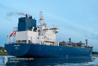
YARA KARA
Tanker D
Current Trip
| Trip Time | 16 days |
|---|---|
| Trip Distance | 5383.96 nm |
| AVG Speed | 13.7 Knop |
| MAX Speed | 17 Knop |
| Djupgående | 7.1 m |
| AVG Wind | 14.9 knots |
| MAX Wind | 32 knots |
| MIN Temp | 4.2°C / 39.56°F |
| MAX Temp | 29.1°C / 84.38°F |
| Position mottagen | 8 h, 24 m sen |
Current Position
| Longitud | -95.33969° |
|---|---|
| Latitude | 28.93737° |
| Status | Moored |
| Fart | |
| Kurs | 85° |
| Område | Gulf of Mexico |
| Station | T-AIS |
| Position mottagen | 8 h, 24 m sen |
Info
Information
The current position of YARA KARA is in Gulf of Mexico with coordinates 28.93737° / -95.33969° as reported on 2024-05-16 01:05 by AIS to our vessel tracker app. The vessel's current speed is 0 Knop and is currently inside the port of FREEPORT (TX).
The vessel YARA KARA (IMO: 9734836, MMSI: 258915000) is a Tanker D It's sailing under the flag of [NO] Norway.
In this page you can find informations about the vessels current position, last detected port calls, and current voyage information. If the vessels is not in coverage by AIS you will find the latest position.
The current position of YARA KARA is detected by our AIS receivers and we are not responsible for the reliability of the data. The last position was recorded while the vessel was in Coverage by the Ais receivers of our vessel tracking app.
The current draught of YARA KARA as reported by AIS is 7.1 meters
Weather
| Temperature | 24.5°C / 76.1°F |
|---|---|
| Wind Speed | 8 knots |
| Direction | 154° SSE |
| Pressure | 1007.4 hPa |
| Humidity | 76.8 % |
| Cloud Coverage | 100 % |
Featured Company
Last Port Calls
| Port | Arrival | Departure | Time In Port |
|---|---|---|---|
| 2024-05-15 21:38 | |||
| 2024-04-27 18:07 | 2024-04-29 15:23 | 1 d | |
| 2024-04-11 16:44 | 2024-04-12 14:44 | 22 h | |
| 2024-03-25 03:24 | 2024-03-25 21:38 | 18 h | |
| 2024-03-23 07:52 | 2024-03-23 23:05 | 15 h | |
| 2024-03-12 09:09 | 2024-03-14 00:04 | 1 d |
Last Trips
| Origin | Departure | Destination | Arrival | Distance | |
|---|---|---|---|---|---|
| 2024-04-29 16:23 | 2024-05-15 16:38 | 5383.96 nm | |||
| 2024-04-12 10:44 | 2024-04-27 19:07 | 4300.11 nm | |||
| 2024-03-25 22:38 | 2024-04-11 12:44 | 4797.09 nm | |||
| 2024-03-24 00:05 | 2024-03-25 04:24 | 354.48 nm | |||
| 2024-03-14 01:04 | 2024-03-23 08:52 | 2244.99 nm | |||
| 2024-02-29 13:28 | 2024-03-12 10:09 | 2958.67 nm |
Events
| Tid | Event | Detaljer | Position / Dest | Information |
|---|---|---|---|---|
| 2024-05-16 01:08 | Status ändrad | Default Moored |
28.93667 / -95.33833
[US] FREEPORT (TX)
|
Fart: Kurs: 85° |
| 2024-05-16 01:05 | Status ändrad | Moored Default |
28.93737 / -95.33969
[US] FREEPORT (TX)
|
Fart: Kurs: 85° |
| 2024-05-16 01:05 | UTANFÖR täckningsområde |
28.93737 / -95.33969
Gulf of Mexico
[US] FREEPORT (TX)
|
Fart: Kurs: 133.9° |
|
| 2024-05-16 00:47 | I täckningsområde |
28.93737 / -95.33969
Gulf of Mexico
[US] FREEPORT (TX)
|
Fart: Kurs: 133.9° |
|
| 2024-05-15 22:14 | STOPPAR förflyttning |
28.93736 / -95.33968
[US] FREEPORT (TX)
|
Fart: 0.1 kn Kurs: 83° |
|
| 2024-05-15 21:38 | ANLÄNDER HAMN |
|
28.94229 / -95.31506
[US] FREEPORT (TX)
|
Fart: 6.5 kn Kurs: 278° |
| 2024-05-15 19:42 | Status ändrad | Default Under way using engine |
28.67635 / -95.02402
GBTEE>>USFPO
|
Fart: 14.8 kn Kurs: 318.9° |
| 2024-05-15 19:37 | UTANFÖR täckningsområde |
28.66044 / -95.00791
Gulf of Mexico
GBTEE>>USFPO
|
Fart: 14.8 kn Kurs: 318.9° |
|
| 2024-05-15 19:32 | Status ändrad | Under way using engine Default |
28.64362 / -94.99143
GBTEE>>USFPO
|
Fart: 14.6 kn Kurs: 320° |
| 2024-05-15 18:58 | Status ändrad | Default Under way using engine |
28.54185 / -94.88792
GBTEE>>USFPO
|
Fart: 14.3 kn Kurs: 321.5° |