
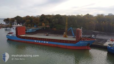
WILSON GDYNIA
General Cargo
Current Trip
| Trip Time | 12 days |
|---|---|
| Trip Distance | 2515.82 nm |
| AVG Speed | 7.9 Knop |
| MAX Speed | 12.9 Knop |
| Djupgående | 5.7 m |
| AVG Wind | 17.6 knots |
| MAX Wind | 26.1 knots |
| MIN Temp | 1.6°C / 34.88°F |
| MAX Temp | 16.5°C / 61.7°F |
| Position mottagen | 2 m sen |
Current Position
| Longitud | --- |
|---|---|
| Latitude | --- |
| Status | Moored |
| Fart | |
| Kurs | 163° |
| Område | North Sea |
| Station | T-AIS |
| Position mottagen | 2 m sen |
Info
Information
The current position of WILSON GDYNIA is in North Sea with coordinates 51.88979° / 4.27554° as reported on 2025-02-17 05:53 by AIS to our vessel tracker app. The vessel's current speed is 0 Knop and is currently inside the port of BOTLEK - ROTTERDAM.
The vessel WILSON GDYNIA (IMO: 9056064, MMSI: 314192000) is a General Cargo that was built in 1994 ( 31 År gammal ). It's sailing under the flag of [BB] Barbados.
In this page you can find informations about the vessels current position, last detected port calls, and current voyage information. If the vessels is not in coverage by AIS you will find the latest position.
The current position of WILSON GDYNIA is detected by our AIS receivers and we are not responsible for the reliability of the data. The last position was recorded while the vessel was in Coverage by the Ais receivers of our vessel tracking app.
The current draught of WILSON GDYNIA as reported by AIS is 5.7 meters
Weather
| Temperature | -1.3°C / 29.66°F |
|---|---|
| Wind Speed | 8 knots |
| Direction | 78° ENE |
| Pressure | 1024.5 hPa |
| Humidity | 67.3 % |
| Cloud Coverage | 30 % |
Featured Company
Last Port Calls
| Port | Arrival | Departure | Time In Port |
|---|---|---|---|
| 2025-02-16 17:54 | |||
| 2025-02-02 07:42 | 2025-02-04 07:33 | 1 d | |
| 2025-01-23 06:45 | 2025-01-24 12:37 | 1 d | |
| 2025-01-09 21:31 | 2025-01-14 06:30 | 4 d | |
| 2025-01-06 08:55 | 2025-01-08 17:59 | 2 d | |
| 2024-12-30 10:17 | 2024-12-31 19:22 | 1 d | |
| 2024-12-27 07:13 | 2024-12-28 12:01 | 1 d | |
| 2024-12-15 10:34 | 2024-12-17 08:23 | 1 d | |
| 2024-12-11 02:14 | 2024-12-11 16:24 | 14 h | |
| 2024-12-06 07:08 | 2024-12-06 07:54 | 46 m |
Last Trips
| Origin | Departure | Destination | Arrival | Distance | |
|---|---|---|---|---|---|
| 2025-02-04 08:33 | 2025-02-16 18:54 | 2515.82 nm | |||
| 2025-01-24 15:37 | 2025-02-02 08:42 | 1745.84 nm | |||
| 2025-01-14 08:30 | 2025-01-23 09:45 | 518.75 nm | |||
| 2025-01-08 19:59 | 2025-01-09 23:31 | 270.60 nm | |||
| 2024-12-31 20:22 | 2025-01-06 10:55 | 1211.41 nm | |||
| 2024-12-28 13:01 | 2024-12-30 11:17 | 434.17 nm | |||
| 2024-12-17 09:23 | 2024-12-27 08:13 | 1736.41 nm | |||
| 2024-12-11 16:24 | 2024-12-15 11:34 | 702.80 nm | |||
| 2024-12-06 08:54 | 2024-12-11 02:14 | 873.05 nm | |||
| 2024-12-03 01:00 | 2024-12-06 08:08 | 711.67 nm |
Events
| Tid | Event | Detaljer | Position / Dest | Information |
|---|---|---|---|---|
| 2025-02-16 18:54 | Status ändrad | Moored Under way using engine |
51.88988 / 4.27557
[NL] BOTLEK - ROTTERDAM
|
Fart: Kurs: 163° |
| 2025-02-16 18:10 | STOPPAR förflyttning |
51.88977 / 4.27546
[NL] BOTLEK - ROTTERDAM
|
Fart: 0.3 kn Kurs: 162° |
|
| 2025-02-16 17:54 | ANLÄNDER HAMN |
|
51.88438 / 4.27897
[NL] BOTLEK - ROTTERDAM
|
Fart: 0.6 kn Kurs: 265° |
| 2025-02-16 15:27 | Status ändrad | Under way using engine Default |
51.98973 / 3.78824
NLRTM
|
Fart: 8.2 kn Kurs: 80° |
| 2025-02-16 15:23 | Status ändrad | Default Under way using engine |
51.98879 / 3.76912
NLRTM
|
Fart: 5.7 kn Kurs: 130.9° |
| 2025-02-16 15:16 | Status ändrad | Under way using engine Default |
51.99162 / 3.75475
NLRTM
|
Fart: 10.4 kn Kurs: 40° |
| 2025-02-16 14:58 | I täckningsområde |
51.99160 / 3.75502
North Sea
NLRTM
|
Fart: 6.9 kn Kurs: 75.1° |
|
| 2025-02-16 14:14 | Status ändrad | Default Under way using engine |
51.92697 / 3.50637
NLRTM
|
Fart: 9.2 kn Kurs: 73.2° |
| 2025-02-16 14:09 | UTANFÖR täckningsområde |
51.92431 / 3.49173
North Sea
NLRTM
|
Fart: 9.2 kn Kurs: 73.2° |
|
| 2025-02-16 10:22 | Upptäckt i hav | Dutch part of the North Sea |
51.76362 / 2.72671
North Sea
NLRTM
|
Fart: 7.1 kn Kurs: 60.1° |