
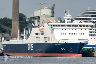
VICTORIA SEAWAYS
Ro-Ro/Passenger Ship
Current Trip
| Time Travelled | 10 h, 49 mins |
|---|---|
| Remaining Time | 9 h, 0 mins |
| Distance Travelled | 208.01 nm |
| Remaining Distance | --- |
| AVG Speed | 18.9 Knop |
| MAX Speed | 20.6 Knop |
| AVG Wind | 10.8 knots |
| MAX Wind | 20 knots |
| MIN Temp | -0.9°C / 30.38°F |
| MAX Temp | 3.7°C / 38.66°F |
| Djupgående | 5.9 m |
| Position mottagen | 1 m sen |
Current Position
| Longitud | --- |
|---|---|
| Latitude | --- |
| Status | Under way using engine |
| Fart | 20.1 Knop |
| Kurs | 71.7° |
| Område | Kattegat |
| Station | T-AIS |
| Position mottagen | 1 m sen |
Info
Information
The current position of VICTORIA SEAWAYS is in Kattegat with coordinates 55.07382° / 15.73481° as reported on 2025-03-18 05:34 by AIS to our vessel tracker app. The vessel's current speed is 20.1 Knop and is heading at the port of KLAIPEDA. The estimated time of arrival as calculated by MyShipTracking vessel tracking app is 2025-03-18 16:35 LT
The vessel VICTORIA SEAWAYS (IMO: 9350721, MMSI: 277408000) is a Ro-Ro/Passenger Ship that was built in 2009 ( 16 År gammal ). It's sailing under the flag of [LT] Lithuania.
In this page you can find informations about the vessels current position, last detected port calls, and current voyage information. If the vessels is not in coverage by AIS you will find the latest position.
The current position of VICTORIA SEAWAYS is detected by our AIS receivers and we are not responsible for the reliability of the data. The last position was recorded while the vessel was in Coverage by the Ais receivers of our vessel tracking app.
The current draught of VICTORIA SEAWAYS as reported by AIS is 5.9 meters
Weather
| Temperature | 3.1°C / 37.58°F |
|---|---|
| Wind Speed | 20 knots |
| Direction | 287° WNW |
| Pressure | 1027 hPa |
| Humidity | 78.3 % |
| Cloud Coverage | 8 % |
Featured Company
Last Port Calls
| Port | Arrival | Departure | Time In Port |
|---|---|---|---|
| 2025-03-16 19:29 | 2025-03-17 19:46 | 1 d | |
| 2025-03-15 19:23 | 2025-03-16 00:03 | 4 h | |
| 2025-03-14 17:58 | 2025-03-14 22:33 | 4 h | |
| 2025-03-13 18:17 | 2025-03-13 23:02 | 4 h | |
| 2025-03-12 17:06 | 2025-03-12 21:37 | 4 h | |
| 2025-03-11 17:16 | 2025-03-11 21:09 | 3 h | |
| 2025-03-09 19:30 | 2025-03-10 19:26 | 23 h | |
| 2025-03-08 19:18 | 2025-03-08 23:30 | 4 h | |
| 2025-03-07 18:07 | 2025-03-07 22:14 | 4 h | |
| 2025-03-06 18:18 | 2025-03-06 23:29 | 5 h |
Most Visited Ports (Last year)
| Port | Arrivals | |
|---|---|---|
| 153 | ||
| 152 | ||
| 1 | ||
| 1 |
Last Trips
| Origin | Departure | Destination | Arrival | Distance | |
|---|---|---|---|---|---|
| 2025-03-16 00:03 | 2025-03-16 19:29 | 399.57 nm | |||
| 2025-03-14 22:33 | 2025-03-15 19:23 | 399.09 nm | |||
| 2025-03-13 23:02 | 2025-03-14 17:58 | 402.14 nm | |||
| 2025-03-12 21:37 | 2025-03-13 18:17 | 398.19 nm | |||
| 2025-03-11 21:09 | 2025-03-12 17:06 | 400.22 nm | |||
| 2025-03-10 19:26 | 2025-03-11 17:16 | 397.76 nm | |||
| 2025-03-08 23:30 | 2025-03-09 19:30 | 400.17 nm | |||
| 2025-03-07 22:14 | 2025-03-08 19:18 | 397.97 nm | |||
| 2025-03-06 23:29 | 2025-03-07 18:07 | 399.72 nm | |||
| 2025-03-05 21:44 | 2025-03-06 18:18 | 398.24 nm |
Events
| Tid | Event | Detaljer | Position / Dest | Information |
|---|---|---|---|---|
| 2025-03-18 02:40 | Byter havsområde | Danish part of the Kattegat German part of the Baltic Sea |
54.90329 / 14.09081
Kattegat
LTKLJ-DEKEL-LTKLJ
|
Fart: 20.2 kn Kurs: 84.2° |
| 2025-03-18 01:32 | Status ändrad | Under way using engine Default |
54.84236 / 13.44245
LTKLJ-DEKEL-LTKLJ
|
Fart: 19.9 kn Kurs: 70° |
| 2025-03-18 01:30 | Status ändrad | Default Under way using engine |
54.83810 / 13.42125
LTKLJ-DEKEL-LTKLJ
|
Fart: 20 kn Kurs: 70.2° |
| 2025-03-17 22:50 | Byter havsområde | German part of the Baltic Sea Danish part of the Baltic Sea |
54.41712 / 12.15016
Baltic Sea
LTKLJ-DEKEL-LTKLJ
|
Fart: 20.2 kn Kurs: 79.2° |
| 2025-03-17 21:32 | Byter havsområde | Danish part of the Baltic Sea German part of the Baltic Sea |
54.50406 / 11.43516
Baltic Sea
LTKLJ-DEKEL-LTKLJ
|
Fart: 20.1 kn Kurs: 112.5° |
| 2025-03-17 20:17 | Byter havsområde | German part of the Baltic Sea Danish part of the Baltic Sea |
54.56707 / 10.78490
Baltic Sea
LTKLJ-DEKEL-LTKLJ
|
Fart: 19.6 kn Kurs: 85.7° |
| 2025-03-17 20:02 | Byter havsområde | Danish part of the Baltic Sea German part of the Baltic Sea |
54.56016 / 10.64128
Baltic Sea
LTKLJ-DEKEL-LTKLJ
|
Fart: 20.3 kn Kurs: 81.2° |
| 2025-03-17 18:46 | AVGÅTT HAMN |
|
54.36402 / 10.17329
LTKLJ-DEKEL-LTKLJ
|
Fart: 10.2 kn Kurs: 27° |
| 2025-03-17 18:35 | STARTAR förflyttning |
54.33652 / 10.16332
[DE] KIEL
|
Fart: 3.2 kn Kurs: 308° |
|
| 2025-03-17 18:25 | Djupgående ändrat | 5.9 5.8 |
54.33562 / 10.16718
[DE] KIEL
|
Fart: Kurs: 232° |