
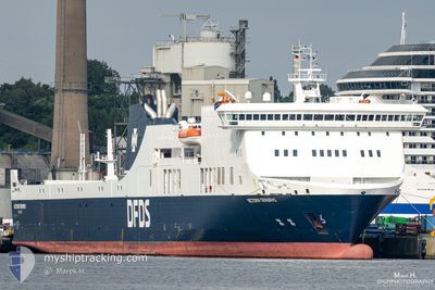
VICTORIA SEAWAYS
Ro-Ro/Passenger Ship
Current Trip
| Time Travelled | 17 h, 24 mins |
|---|---|
| Remaining Time | 2 h, 21 mins |
| Distance Travelled | 353.46 nm |
| Remaining Distance | 50.67 nm |
| AVG Speed | 20 Knopen |
| MAX Speed | 21.4 Knopen |
| AVG Wind | 17.5 knots |
| MAX Wind | 25.4 knots |
| MIN Temp | 0.5°C / 32.9°F |
| MAX Temp | 5°C / 41°F |
| Diepgang | 6 M |
| Positie ontvangen | 1 m geleden |
Current Position
| Lengtegraad | --- |
|---|---|
| Breedtegraat | --- |
| Status | Under way using engine |
| Snelheid | 20.2 Knopen |
| Koers | 293.2° |
| Gebied | Baltic Sea |
| Station | T-AIS |
| Positie ontvangen | 1 m geleden |
Info
Information
The current position of VICTORIA SEAWAYS is in Baltic Sea with coordinates 54.56526° / 11.30022° as reported on 2024-11-22 14:24 by AIS to our vessel tracker app. The vessel's current speed is 20.2 Knopen and is heading at the port of KIEL. The estimated time of arrival as calculated by MyShipTracking vessel tracking app is 2024-11-22 17:46 LT
The vessel VICTORIA SEAWAYS (IMO: 9350721, MMSI: 277408000) is a Ro-Ro/Passenger Ship that was built in 2009 ( 15 Jaar oud ). It's sailing under the flag of [LT] Lithuania.
In this page you can find informations about the vessels current position, last detected port calls, and current voyage information. If the vessels is not in coverage by AIS you will find the latest position.
The current position of VICTORIA SEAWAYS is detected by our AIS receivers and we are not responsible for the reliability of the data. The last position was recorded while the vessel was in Coverage by the Ais receivers of our vessel tracking app.
The current draught of VICTORIA SEAWAYS as reported by AIS is 6 meters
Weather
| Temperature | 5.1°C / 41.18°F |
|---|---|
| Wind Speed | 24 knots |
| Direction | 236° SW |
| Pressure | 993 hPa |
| Humidity | 83.7 % |
| Cloud Coverage | 100 % |
Featured Company
Last Port Calls
| Port | Arrival | Departure | Time In Port |
|---|---|---|---|
| 2024-11-21 18:32 | 2024-11-21 23:01 | 4 h | |
| 2024-11-20 16:58 | 2024-11-20 21:48 | 4 h | |
| 2024-11-19 16:44 | 2024-11-19 21:01 | 4 h | |
| 2024-11-17 19:34 | 2024-11-18 19:37 | 1 d | |
| 2024-11-16 19:18 | 2024-11-17 00:20 | 5 h | |
| 2024-11-15 17:59 | 2024-11-15 22:09 | 4 h | |
| 2024-11-14 18:20 | 2024-11-14 22:31 | 4 h | |
| 2024-11-13 17:00 | 2024-11-13 21:28 | 4 h | |
| 2024-11-12 17:26 | 2024-11-12 21:51 | 4 h | |
| 2024-11-10 19:31 | 2024-11-11 19:46 | 1 d |
Last Trips
| Origin | Departure | Destination | Arrival | Distance | |
|---|---|---|---|---|---|
| 2024-11-20 21:48 | 2024-11-21 18:32 | 399.06 nm | |||
| 2024-11-19 21:01 | 2024-11-20 16:58 | 400.07 nm | |||
| 2024-11-18 19:37 | 2024-11-19 16:44 | 400.39 nm | |||
| 2024-11-17 00:20 | 2024-11-17 19:34 | 400.29 nm | |||
| 2024-11-15 22:09 | 2024-11-16 19:18 | 398.81 nm | |||
| 2024-11-14 22:31 | 2024-11-15 17:59 | 400.61 nm | |||
| 2024-11-13 21:28 | 2024-11-14 18:20 | 398.19 nm | |||
| 2024-11-12 21:51 | 2024-11-13 17:00 | 401.33 nm | |||
| 2024-11-11 19:46 | 2024-11-12 17:26 | 399.64 nm | |||
| 2024-11-10 00:28 | 2024-11-10 19:31 | 400.02 nm |
Events
| Tijd | Evenement | Details | Positie / Bestemming | Info |
|---|---|---|---|---|
| 2024-11-22 14:19 | Wijzig zee gebeid | German part of the Baltic Sea Danish part of the Baltic Sea |
54.55409 / 11.34437
Baltic Sea
LTKLJ-DEKEL-LTKLJ
|
Snelheid: 20.3 kn Koers: 293.1° |
| 2024-11-22 12:52 | Wijzig zee gebeid | Danish part of the Baltic Sea German part of the Baltic Sea |
54.44762 / 12.13679
Baltic Sea
LTKLJ-DEKEL-LTKLJ
|
Snelheid: 19.7 kn Koers: 270° |
| 2024-11-22 12:40 | Wijzig zee gebeid | German part of the Baltic Sea Danish part of the Baltic Sea |
54.48752 / 12.21060
Baltic Sea
LTKLJ-DEKEL-LTKLJ
|
Snelheid: 20.3 kn Koers: 197° |
| 2024-11-22 12:04 | Wijzig zee gebeid | Danish part of the Baltic Sea German part of the Baltic Sea |
54.64897 / 12.39491
Baltic Sea
LTKLJ-DEKEL-LTKLJ
|
Snelheid: 20 kn Koers: 229.5° |
| 2024-11-22 11:44 | Wijzig zee gebeid | German part of the Baltic Sea Danish part of the Baltic Sea |
54.71087 / 12.54759
Baltic Sea
LTKLJ-DEKEL-LTKLJ
|
Snelheid: 19.2 kn Koers: 237.3° |
| 2024-11-22 11:11 | Wijzig zee gebeid | Danish part of the Baltic Sea German part of the Baltic Sea |
54.79283 / 12.81831
Baltic Sea
LTKLJ-DEKEL-LTKLJ
|
Snelheid: 20.1 kn Koers: 269.5° |
| 2024-11-22 10:13 | Status Changed | Under way using engine Default |
54.83778 / 13.36507
LTKLJ-DEKEL-LTKLJ
|
Snelheid: 20.2 kn Koers: 257° |
| 2024-11-22 10:01 | Status Changed | Default Under way using engine |
54.85315 / 13.48161
LTKLJ-DEKEL-LTKLJ
|
Snelheid: 21.2 kn Koers: 256.3° |
| 2024-11-22 09:01 | Wijzig zee gebeid | German part of the Baltic Sea Danish part of the Kattegat |
54.90197 / 14.06335
Baltic Sea
LTKLJ-DEKEL-LTKLJ
|
Snelheid: 20.3 kn Koers: 264.7° |
| 2024-11-22 05:59 | Wijzig zee gebeid | Danish part of the Kattegat Polish part of the Baltic Sea |
55.05071 / 15.80475
Kattegat
LTKLJ-DEKEL-LTKLJ
|
Snelheid: 20.8 kn Koers: 258° |