

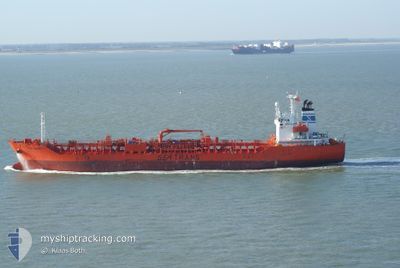
TRANS ADRIATIC
Oil/Chemical Tanker

Current Trip
| Time Travelled | 1 day |
|---|---|
| Remaining Time | --- |
| Distance Travelled | 307.77 nm |
| Remaining Distance | --- |
| AVG Speed | 11.4 Knop |
| MAX Speed | 15.1 Knop |
| AVG Wind | 7.9 knots |
| MAX Wind | 12 knots |
| MIN Temp | 4.6°C / 40.28°F |
| MAX Temp | 8.1°C / 46.58°F |
| Djupgående | 8.5 m |
| Position mottagen | 6 m sen |
Current Position
| Longitud | --- |
|---|---|
| Latitude | --- |
| Status | Under way using engine |
| Fart | 14.5 Knop |
| Kurs | 206° |
| Område | North Sea |
| Station | T-AIS |
| Position mottagen | 6 m sen |
Information
The current position of TRANS ADRIATIC is in North Sea with coordinates 52.45335° / 2.87223° as reported on 2025-03-02 11:49 by AIS to our vessel tracker app. The vessel's current speed is 14.5 Knop and is heading at the port of HUELVA. The estimated time of arrival as calculated by MyShipTracking vessel tracking app is 2025-03-06 17:00 LT
The vessel TRANS ADRIATIC (IMO: 9263928, MMSI: 311041700) is a Oil/Chemical Tanker that was built in 2002 ( 23 År gammal ). It's sailing under the flag of [BS] Bahamas.
In this page you can find informations about the vessels current position, last detected port calls, and current voyage information. If the vessels is not in coverage by AIS you will find the latest position.
The current position of TRANS ADRIATIC is detected by our AIS receivers and we are not responsible for the reliability of the data. The last position was recorded while the vessel was in Coverage by the Ais receivers of our vessel tracking app.
The current draught of TRANS ADRIATIC as reported by AIS is 8.5 meters
Weather
| Temperature | 5.9°C / 42.62°F |
|---|---|
| Wind Speed | 7 knots |
| Direction | 196° SSW |
| Pressure | 1035.4 hPa |
| Humidity | 73.7 % |
| Cloud Coverage | 2 % |


Featured Company
Last Port Calls
| Port | Arrival | Departure | Time In Port |
|---|---|---|---|
| 2025-03-01 00:12 | 2025-03-01 11:01 | 10 h | |
| 2025-02-25 12:24 | 2025-02-26 18:35 | 1 d | |
| 2025-02-21 16:30 | 2025-02-25 00:56 | 3 d | |
| 2025-02-14 13:29 | 2025-02-20 10:05 | 5 d | |
| 2025-02-06 21:53 | 2025-02-08 00:11 | 1 d | |
| 2025-02-05 22:38 | 2025-02-06 10:58 | 12 h | |
| 2025-02-03 19:39 | 2025-02-04 03:06 | 7 h | |
| 2025-01-24 07:15 | 2025-01-27 10:10 | 3 d | |
| 2025-01-05 20:16 | 2025-01-12 18:33 | 6 d | |
| 2025-01-02 21:17 | 2025-01-04 07:43 | 1 d |
Most Visited Ports (Last year)
| Port | Arrivals | |
|---|---|---|
| 8 | ||
| 6 | ||
| 5 | ||
| 4 | ||
| 4 | ||
| 3 |
Last Trips
| Origin | Departure | Destination | Arrival | Distance | |
|---|---|---|---|---|---|
| 2025-02-26 19:35 | 2025-03-01 01:12 | 361.27 nm | |||
| 2025-02-25 01:56 | 2025-02-25 13:24 | 126.45 nm | |||
| 2025-02-20 11:05 | 2025-02-21 17:30 | 234.53 nm | |||
| 2025-02-08 01:11 | 2025-02-14 14:29 | 1346.15 nm | |||
| 2025-02-06 11:58 | 2025-02-06 22:53 | 129.57 nm | |||
| 2025-02-04 04:06 | 2025-02-05 23:38 | 107.69 nm | |||
| 2025-01-27 13:10 | 2025-02-03 20:39 | 1866.42 nm | |||
| 2025-01-12 19:33 | 2025-01-24 10:15 | 3285.11 nm | |||
| 2025-01-04 08:43 | 2025-01-05 21:16 | 150.27 nm | |||
| 2024-12-26 03:12 | 2025-01-02 22:17 | 2123.78 nm |
Events
| Tid | Event | Detaljer | Position / Dest | Information |
|---|---|---|---|---|
| 2025-03-02 11:50 | Status ändrad | Default Under way using engine |
52.44757 / 2.86758
ESHUV
|
Fart: 14.5 kn Kurs: 206° |
| 2025-03-02 11:34 | Byter havsområde | United Kingdom part of the North Sea Dutch part of the North Sea |
52.50598 / 2.91547
North Sea
ESHUV
|
Fart: 14.5 kn Kurs: 207° |
| 2025-03-02 11:34 | Status ändrad | Under way using engine Default |
52.50598 / 2.91547
ESHUV
|
Fart: 14.5 kn Kurs: 207° |
| 2025-03-02 11:22 | I täckningsområde |
52.50598 / 2.91547
North Sea
ESHUV
|
Fart: 14.5 kn Kurs: 207° |
|
| 2025-03-02 06:33 | Status ändrad | Default Under way using engine |
53.56513 / 3.59018
ESHUV
|
Fart: 12.1 kn Kurs: 193° |
| 2025-03-02 06:20 | Status ändrad | Under way using engine Default |
53.60948 / 3.60813
ESHUV
|
Fart: 11.9 kn Kurs: 191° |
| 2025-03-02 06:20 | UTANFÖR täckningsområde |
53.60948 / 3.60813
North Sea
ESHUV
|
Fart: 12.1 kn Kurs: 193° |
|
| 2025-03-02 06:00 | I täckningsområde |
53.60948 / 3.60813
North Sea
ESHUV
|
Fart: 12.1 kn Kurs: 193° |
|
| 2025-03-02 00:01 | Status ändrad | Default Under way using engine |
54.12532 / 5.61100
ESHUV
|
Fart: 12.3 kn Kurs: 262° |
| 2025-03-01 23:54 | UTANFÖR täckningsområde |
54.12843 / 5.65172
North Sea
ESHUV
|
Fart: 12.3 kn Kurs: 262° |