

TARSUS M
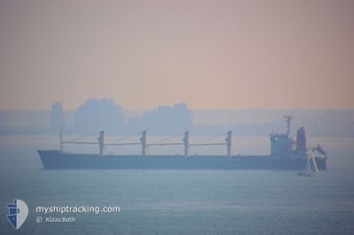
Bulk Carrier

Current Trip
| Trip Time | 5 days |
|---|---|
| Trip Distance | 1273.22 nm |
| AVG Speed | 10.1 Knop |
| MAX Speed | 11.9 Knop |
| Djupgående | 6.2 m |
| AVG Wind | 11 knots |
| MAX Wind | 26 knots |
| MIN Temp | 24.7°C / 76.46°F |
| MAX Temp | 28.4°C / 83.12°F |
| Position mottagen | 11 d sen |
Current Position
| Longitud | --- |
|---|---|
| Latitude | --- |
| Status | Under way using engine |
| Fart | 10.9 Knop |
| Kurs | 71° |
| Område | Gulf of Aden |
| Station | T-AIS |
| Position mottagen | 11 d sen |
Information
The current position of TARSUS M is in Gulf of Aden with coordinates 13.53910° / 50.40628° as reported on 2025-03-15 18:25 by AIS to our vessel tracker app. The vessel's current speed is 10.9 Knop and is currently inside the port of AL DUQM.
The vessel TARSUS M (IMO: 9188908, MMSI: 352001472) is a Bulk Carrier that was built in 2006 ( 19 År gammal ). It's sailing under the flag of [PA] Panama.
In this page you can find informations about the vessels current position, last detected port calls, and current voyage information. If the vessels is not in coverage by AIS you will find the latest position.
The current position of TARSUS M is detected by our AIS receivers and we are not responsible for the reliability of the data. The last position was recorded while the vessel was in Coverage by the Ais receivers of our vessel tracking app.
The current draught of TARSUS M as reported by AIS is 6.2 meters
Weather
| Temperature | 24.6°C / 76.28°F |
|---|---|
| Wind Speed | 12 knots |
| Direction | 101° E |
| Pressure | 1013.6 hPa |
| Humidity | 65 % |
| Cloud Coverage | 71 % |


Featured Company
Last Port Calls
Most Visited Ports (Last year)
| Port | Arrivals | |
|---|---|---|
| 3 | ||
| 2 | ||
| 2 | ||
| 1 | ||
| 1 | ||
| 1 |
Last Trips
| Origin | Departure | Destination | Arrival | Distance | |
|---|---|---|---|---|---|
| 2025-03-13 08:00 | 2025-03-19 04:08 | 1273.22 nm | |||
| 2025-02-27 14:49 | 2025-03-08 17:45 | 252.58 nm | |||
| 2025-02-25 11:46 | 2025-02-27 05:13 | 158.44 nm | |||
| 2025-02-06 07:50 | 2025-02-23 09:07 | 4210.35 nm | |||
| 2025-01-06 16:56 | 2025-01-31 12:04 | 5047.46 nm | |||
| 2024-12-29 08:54 | 2025-01-04 08:13 | 1202.21 nm |
Events
| Tid | Event | Detaljer | Position / Dest | Information |
|---|---|---|---|---|
| 2025-03-19 00:31 | STOPPAR förflyttning |
19.66440 / 57.71594
[OM] AL DUQM
|
Fart: 0.3 kn Kurs: 148° |
|
| 2025-03-19 00:08 | ANLÄNDER HAMN |
|
19.68170 / 57.72332
[OM] AL DUQM
|
Fart: 7.9 kn Kurs: 206° |
| 2025-03-18 23:50 | STARTAR förflyttning | 3.09 nm, North East of AL DUQM |
19.70838 / 57.74726
OM DQM
|
Fart: 3.4 kn Kurs: 262° |
| 2025-03-18 23:16 | STOPPAR förflyttning | 3.01 nm, North East of AL DUQM |
19.70502 / 57.74792
OM DQM
|
Fart: 0.2 kn Kurs: 264° |
| 2025-03-18 18:35 | STARTAR förflyttning | 3.86 nm, North East of AL DUQM |
19.70932 / 57.76257
OM DQM
|
Fart: 3.7 kn Kurs: 175° |
| 2025-03-18 18:07 | STOPPAR förflyttning | 3.82 nm, North East of AL DUQM |
19.71295 / 57.75957
OM DQM
|
Fart: 0.2 kn Kurs: 195° |
| 2025-03-18 16:26 | STARTAR förflyttning | 8.37 nm, North East of AL DUQM |
19.74005 / 57.83543
OM DQM
|
Fart: 3.7 kn Kurs: 193° |
| 2025-03-18 06:45 | STOPPAR förflyttning | 8.46 nm, North East of AL DUQM |
19.74373 / 57.83530
OM DQM
|
Fart: 0.2 kn Kurs: 188° |