
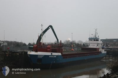
SVEALAND
General Cargo
Current Trip
| Time Travelled | 1 day |
|---|---|
| Remaining Time | 2 h, 33 mins |
| Distance Travelled | 307.05 nm |
| Remaining Distance | 17.32 nm |
| AVG Speed | 8.6 Knop |
| MAX Speed | 14.2 Knop |
| AVG Wind | 24.7 knots |
| MAX Wind | 32.9 knots |
| MIN Temp | 1°C / 33.8°F |
| MAX Temp | 7.4°C / 45.32°F |
| Djupgående | 3.7 m |
| Position mottagen | 1 m sen |
Current Position
| Longitud | --- |
|---|---|
| Latitude | --- |
| Status | Under way using engine |
| Fart | 6.1 Knop |
| Kurs | 346.2° |
| Område | North Sea |
| Station | T-AIS |
| Position mottagen | 1 m sen |
Information
The current position of SVEALAND is in North Sea with coordinates 58.06275° / 6.29343° as reported on 2025-02-21 01:11 by AIS to our vessel tracker app. The vessel's current speed is 6.1 Knop and is heading at the port of REKEFJORD. The estimated time of arrival as calculated by MyShipTracking vessel tracking app is 2025-02-21 03:45 LT
The vessel SVEALAND (IMO: 9195743, MMSI: 211815120) is a General Cargo that was built in 2001 ( 24 År gammal ). It's sailing under the flag of [DE] Germany.
In this page you can find informations about the vessels current position, last detected port calls, and current voyage information. If the vessels is not in coverage by AIS you will find the latest position.
The current position of SVEALAND is detected by our AIS receivers and we are not responsible for the reliability of the data. The last position was recorded while the vessel was in Coverage by the Ais receivers of our vessel tracking app.
The current draught of SVEALAND as reported by AIS is 3.7 meters
Weather
| Temperature | 6.8°C / 44.24°F |
|---|---|
| Wind Speed | 12 knots |
| Direction | 200° SSW |
| Pressure | 1010.8 hPa |
| Humidity | 94.8 % |
| Cloud Coverage | 100 % |
Featured Company
Last Port Calls
| Port | Arrival | Departure | Time In Port |
|---|---|---|---|
| 2025-02-17 11:28 | 2025-02-19 14:49 | 2 d | |
| 2025-02-10 16:33 | 2025-02-14 16:17 | 3 d | |
| 2025-02-08 17:04 | 2025-02-10 09:16 | 1 d | |
| 2025-02-04 11:02 | 2025-02-06 17:48 | 2 d | |
| 2025-01-30 11:09 | 2025-02-03 19:16 | 4 d | |
| 2025-01-25 19:31 | 2025-01-29 17:07 | 3 d | |
| 2025-01-23 05:57 | 2025-01-24 07:59 | 1 d | |
| 2025-01-20 13:42 | 2025-01-21 09:49 | 20 h | |
| 2025-01-13 20:19 | 2025-01-16 11:03 | 2 d | |
| 2024-12-31 16:21 | 2025-01-04 21:49 | 4 d |
Last Trips
| Origin | Departure | Destination | Arrival | Distance | |
|---|---|---|---|---|---|
| 2025-02-14 18:17 | 2025-02-17 12:28 | 557.03 nm | |||
| 2025-02-10 11:16 | 2025-02-10 18:33 | 72.57 nm | |||
| 2025-02-06 18:48 | 2025-02-08 19:04 | 346.85 nm | |||
| 2025-02-03 20:16 | 2025-02-04 12:02 | 164.90 nm | |||
| 2025-01-29 18:07 | 2025-01-30 12:09 | 167.69 nm | |||
| 2025-01-24 08:59 | 2025-01-25 20:31 | 312.22 nm | |||
| 2025-01-21 09:49 | 2025-01-23 06:57 | 428.67 nm | |||
| 2025-01-16 11:03 | 2025-01-20 13:42 | 706.55 nm | |||
| 2025-01-04 23:49 | 2025-01-13 20:19 | 1439.70 nm | |||
| 2024-12-30 19:56 | 2024-12-31 18:21 | 220.30 nm |
Events
| Tid | Event | Detaljer | Position / Dest | Information |
|---|---|---|---|---|
| 2025-02-20 17:01 | Byter havsområde | Norwegian part of the North Sea Danish part of the North Sea |
57.19864 / 6.99790
North Sea
NOREK
|
Fart: 6.6 kn Kurs: 330.4° |
| 2025-02-20 16:33 | Status ändrad | Under way using engine Default |
57.15104 / 7.03842
NOREK
|
Fart: 6.7 kn Kurs: 352° |
| 2025-02-20 16:33 | I täckningsområde |
57.15104 / 7.03842
North Sea
NOREK
|
Fart: 6.5 kn Kurs: 349.5° |
|
| 2025-02-20 14:19 | Status ändrad | Default Under way using engine |
56.89605 / 7.11195
NOREK
|
Fart: 7.5 kn Kurs: 351° |
| 2025-02-20 14:18 | UTANFÖR täckningsområde |
56.89449 / 7.11216
North Sea
NOREK
|
Fart: 7.5 kn Kurs: 351° |
|
| 2025-02-20 13:30 | Status ändrad | Under way using engine Default |
56.79505 / 7.13475
NOREK
|
Fart: 7.6 kn Kurs: 349° |
| 2025-02-20 13:17 | Status ändrad | Default Under way using engine |
56.76684 / 7.14114
NOREK
|
Fart: 7.4 kn Kurs: 348.9° |
| 2025-02-20 13:11 | Status ändrad | Under way using engine Default |
56.75564 / 7.14393
NOREK
|
Fart: 7.7 kn Kurs: 354° |
| 2025-02-20 13:05 | Status ändrad | Default Under way using engine |
56.74350 / 7.14684
NOREK
|
Fart: 7.6 kn Kurs: 352.6° |
| 2025-02-20 12:32 | Status ändrad | Under way using engine Default |
56.67343 / 7.16221
NOREK
|
Fart: 7.9 kn Kurs: 354° |