

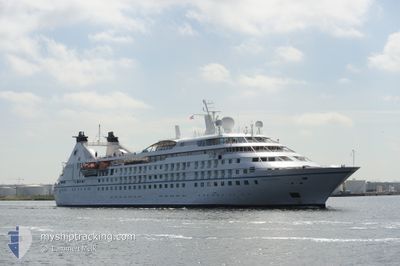
STAR LEGEND
Passengers Ship

Current Trip
| Time Travelled | 15 h, 4 mins |
|---|---|
| Remaining Time | --- |
| Distance Travelled | 115.06 nm |
| Remaining Distance | --- |
| AVG Speed | 11.4 Knop |
| MAX Speed | 11.9 Knop |
| AVG Wind | 11.9 knots |
| MAX Wind | 16 knots |
| MIN Temp | 10.7°C / 51.26°F |
| MAX Temp | 12.8°C / 55.04°F |
| Djupgående | 5.5 m |
| Position mottagen | 5 h, 0 m sen |
Current Position
| Longitud | --- |
|---|---|
| Latitude | --- |
| Status | Under way using engine |
| Fart | 11.4 Knop |
| Kurs | 103.4° |
| Område | Adriatic Sea |
| Station | T-AIS |
| Position mottagen | 5 h, 0 m sen |
Information
The current position of STAR LEGEND is in Adriatic Sea with coordinates 44.45140° / 14.20158° as reported on 2025-03-29 01:52 by AIS to our vessel tracker app. The vessel's current speed is 11.4 Knop
The vessel STAR LEGEND (IMO: 9008598, MMSI: 311085000) is a Passengers Ship that was built in 1992 ( 33 År gammal ). It's sailing under the flag of [BS] Bahamas.
In this page you can find informations about the vessels current position, last detected port calls, and current voyage information. If the vessels is not in coverage by AIS you will find the latest position.
The current position of STAR LEGEND is detected by our AIS receivers and we are not responsible for the reliability of the data. The last position was recorded while the vessel was in Coverage by the Ais receivers of our vessel tracking app.
The current draught of STAR LEGEND as reported by AIS is 5.5 meters
Weather
| Temperature | 12.7°C / 54.86°F |
|---|---|
| Wind Speed | 10 knots |
| Direction | 47° NE |
| Pressure | 1001.3 hPa |
| Humidity | 73 % |
| Cloud Coverage | 100 % |


Featured Company
Last Port Calls
| Port | Arrival | Departure | Time In Port |
|---|---|---|---|
| 2025-03-28 06:06 | 2025-03-28 16:48 | 10 h | |
| 2025-03-24 08:20 | 2025-03-24 18:00 | 9 h | |
| 2025-03-22 07:09 | 2025-03-23 14:14 | 1 d | |
| 2025-03-20 09:04 | 2025-03-20 17:48 | 8 h | |
| 2025-03-19 08:03 | 2025-03-19 17:07 | 9 h | |
| 2025-03-18 06:55 | 2025-03-18 17:22 | 10 h | |
| 2025-03-16 07:10 | 2025-03-17 18:32 | 1 d | |
| 2025-03-15 07:01 | 2025-03-15 22:08 | 15 h | |
| 2025-03-13 16:08 | 2025-03-14 22:16 | 1 d | |
| 2025-03-11 06:09 | 2025-03-12 16:24 | 1 d |
Last Trips
| Origin | Departure | Destination | Arrival | Distance | |
|---|---|---|---|---|---|
| 2025-03-24 18:00 | 2025-03-28 06:06 | 225.16 nm | |||
| 2025-03-23 14:14 | 2025-03-24 08:20 | 242.99 nm | |||
| 2025-03-20 17:48 | 2025-03-22 07:09 | 378.74 nm | |||
| 2025-03-19 17:07 | 2025-03-20 09:04 | 179.78 nm | |||
| 2025-03-18 17:22 | 2025-03-19 08:03 | 159.72 nm | |||
| 2025-03-17 18:32 | 2025-03-18 06:55 | 122.50 nm | |||
| 2025-03-15 22:08 | 2025-03-16 07:10 | 83.56 nm | |||
| 2025-03-14 22:16 | 2025-03-15 07:01 | 91.57 nm | |||
| 2025-03-12 16:24 | 2025-03-13 16:08 | 275.79 nm | |||
| 2025-03-10 17:19 | 2025-03-11 06:09 | 168.03 nm |
Events
| Tid | Event | Detaljer | Position / Dest | Information |
|---|---|---|---|---|
| 2025-03-29 01:53 | Status ändrad | Default Under way using engine |
44.45054 / 14.20665
HR ZAD
|
Fart: 11.4 kn Kurs: 103.4° |
| 2025-03-29 01:52 | UTANFÖR täckningsområde |
44.45140 / 14.20158
Adriatic Sea
HR ZAD
|
Fart: 11.4 kn Kurs: 103.4° |
|
| 2025-03-28 19:38 | Upptäckt i hav | Croatian part of the Adriatic Sea |
45.24408 / 13.04255
Adriatic Sea
HR ZAD
|
Fart: 11.6 kn Kurs: 167.8° |
| 2025-03-28 16:44 | Byter havsområde | Italian part of the Adriatic Sea Slovenian part of the Adriatic Sea |
45.61032 / 13.49855
Adriatic Sea
HR ZAD
|
Fart: 11.2 kn Kurs: 252.1° |
| 2025-03-28 15:48 | AVGÅTT HAMN |
|
45.55735 / 13.71212
HR ZAD
|
Fart: 5.5 kn Kurs: 315° |
| 2025-03-28 15:40 | STARTAR förflyttning |
45.55186 / 13.72753
[SI] KOPER
|
Fart: 4.7 kn Kurs: 295° |
|
| 2025-03-28 15:30 | Status ändrad | Under way using engine Moored |
45.55043 / 13.72965
[SI] KOPER
|
Fart: Kurs: 267° |
| 2025-03-28 15:00 | Djupgående ändrat | 5.5 5 |
45.55045 / 13.72968
[SI] KOPER
|
Fart: Kurs: 267° |
| 2025-03-28 15:00 | ETA ändrat | 2025/03/29 06:00 |
45.55045 / 13.72968
[SI] KOPER
|
Fart: Kurs: 267° |
| 2025-03-28 14:54 | Djupgående ändrat | 5 5.5 |
45.55046 / 13.72967
[SI] KOPER
|
Fart: Kurs: 267° |