
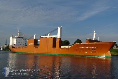
STADIONGRACHT
General Cargo
Current Trip
| Time Travelled | 4 days |
|---|---|
| Remaining Time | 9 h, 23 mins |
| Distance Travelled | 1601.05 nm |
| Remaining Distance | 184.82 nm |
| AVG Speed | 15.9 Knop |
| MAX Speed | 23.3 Knop |
| AVG Wind | 24.2 knots |
| MAX Wind | 35 knots |
| MIN Temp | -3.3°C / 26.06°F |
| MAX Temp | 5.8°C / 42.44°F |
| Djupgående | 10.1 m |
| Position mottagen | 5 h, 14 m sen |
Current Position
| Longitud | --- |
|---|---|
| Latitude | --- |
| Status | Under way using engine |
| Fart | 17.4 Knop |
| Kurs | 219.1° |
| Område | Inner Seas off the West Coast of Scotland |
| Station | T-AIS |
| Position mottagen | 5 h, 14 m sen |
Info
Information
The current position of STADIONGRACHT is in Inner Seas off the West Coast of Scotland with coordinates 57.97721° / -6.29596° as reported on 2026-01-03 21:06 by AIS to our vessel tracker app. The vessel's current speed is 17.4 Knop and is heading at the port of GREENOCK. The estimated time of arrival as calculated by MyShipTracking vessel tracking app is 2026-01-04 11:43 LT
The vessel STADIONGRACHT (IMO: 9202508, MMSI: 246466000) is a General Cargo that was built in 2000 ( 26 År gammal ). It's sailing under the flag of [NL] Netherlands.
In this page you can find informations about the vessels current position, last detected port calls, and current voyage information. If the vessels is not in coverage by AIS you will find the latest position.
The current position of STADIONGRACHT is detected by our AIS receivers and we are not responsible for the reliability of the data. The last position was recorded while the vessel was in Coverage by the Ais receivers of our vessel tracking app.
The current draught of STADIONGRACHT as reported by AIS is 10.1 meters
Weather
| Temperature | 4.3°C / 39.74°F |
|---|---|
| Wind Speed | 25 knots |
| Direction | 352° N |
| Pressure | 1017.2 hPa |
| Humidity | 61.8 % |
| Cloud Coverage | 100 % |
Featured Company
Last Port Calls
| Port | Arrival | Departure | Time In Port |
|---|---|---|---|
| 2025-12-22 09:02 | 2025-12-30 16:13 | 8 d | |
| 2025-12-18 21:21 | 2025-12-19 20:52 | 23 h | |
| 2025-12-05 10:20 | 2025-12-06 12:04 | 1 d | |
| 2025-11-26 01:10 | 2025-11-29 02:21 | 3 d | |
| 2025-11-23 05:11 | 2025-11-25 03:37 | 1 d | |
| 2025-11-17 15:17 | 2025-11-21 01:18 | 3 d | |
| 2025-11-01 12:34 |
Most Visited Ports (Last year)
| Port | Arrivals | |
|---|---|---|
| 6 | ||
| 6 | ||
| 3 | ||
| 3 | ||
| 2 | ||
| 2 |
Last Trips
| Origin | Departure | Destination | Arrival | Distance | |
|---|---|---|---|---|---|
| 2025-12-19 21:52 | 2025-12-22 11:02 | 876.11 nm | |||
| 2025-12-06 08:04 | 2025-12-18 22:21 | 4113.42 nm | |||
| 2025-11-28 21:21 | 2025-12-05 06:20 | 1533.78 nm | |||
| 2025-11-24 22:37 | 2025-11-25 20:10 | 266.09 nm | |||
| 2025-11-20 20:18 | 2025-11-23 00:11 | 745.07 nm | |||
| 2025-11-01 12:34 | 2025-11-17 10:17 | 4644.92 nm |
Events
| Tid | Event | Detaljer | Position / Dest | Information |
|---|---|---|---|---|
| 2026-01-03 21:10 | Status ändrad | Default Under way using engine |
57.96294 / -6.31797
GBGRK
|
Fart: 17.4 kn Kurs: 219.1° |
| 2026-01-03 21:06 | UTANFÖR täckningsområde |
57.97721 / -6.29596
Inner Seas off the West Coast of Scotland
GBGRK
|
Fart: 17.4 kn Kurs: 219.1° |
|
| 2026-01-03 20:57 | Status ändrad | Under way using engine Default |
58.00862 / -6.24544
GBGRK
|
Fart: 16.7 kn Kurs: 222° |
| 2026-01-03 20:55 | Status ändrad | Default Under way using engine |
58.01685 / -6.23183
GBGRK
|
Fart: 17.1 kn Kurs: 221.5° |
| 2026-01-03 19:58 | Upptäckt i hav | United Kingdom part of the Inner Seas off the West Coast of Scotland |
58.21525 / -5.89238
Inner Seas off the West Coast of Scotland
GBGRK
|
Fart: 16.4 kn Kurs: 220.5° |
| 2026-01-03 19:54 | Status ändrad | Under way using engine Default |
58.22857 / -5.87008
GBGRK
|
Fart: 17.6 kn Kurs: 221° |
| 2026-01-03 19:43 | I täckningsområde |
58.21525 / -5.89238
Inner Seas off the West Coast of Scotland
GBGRK
|
Fart: 16.4 kn Kurs: 220.5° |
|
| 2026-01-03 16:34 | Status ändrad | Default Under way using engine |
58.87423 / -4.63689
GBGRK
|
Fart: 17.4 kn Kurs: 238.2° |
| 2026-01-03 16:29 | UTANFÖR täckningsområde |
58.88877 / -4.59340
North Atlantic Ocean
GBGRK
|
Fart: 17.4 kn Kurs: 238.2° |
|
| 2026-01-03 16:25 | Status ändrad | Under way using engine Default |
58.89996 / -4.56205
GBGRK
|
Fart: 17 kn Kurs: 236° |