
ST PETER
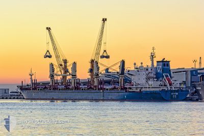
Bulk Carrier
Current Trip
| Trip Time | 4 days |
|---|---|
| Trip Distance | 1117.95 nm |
| AVG Speed | 10.8 Knop |
| MAX Speed | 14.3 Knop |
| Djupgående | 6.3 m |
| AVG Wind | 9.6 knots |
| MAX Wind | 21.2 knots |
| MIN Temp | 4.3°C / 39.74°F |
| MAX Temp | 12.4°C / 54.32°F |
| Position mottagen | 2 m sen |
Current Position
| Longitud | 17.16458° |
|---|---|
| Latitude | 61.20992° |
| Status | Moored |
| Fart | |
| Kurs | 3° |
| Område | Gulf of Bothnia |
| Station | T-AIS |
| Position mottagen | 2 m sen |
Info
Information
The current position of ST PETER is in Gulf of Bothnia with coordinates 61.20992° / 17.16458° as reported on 2024-05-01 11:35 by AIS to our vessel tracker app. The vessel's current speed is 0 Knop and is currently inside the port of LJUSNE.
The vessel ST PETER (IMO: 9437529, MMSI: 311042700) is a Bulk Carrier that was built in 2009 ( 15 År gammal ). It's sailing under the flag of [BS] Bahamas.
In this page you can find informations about the vessels current position, last detected port calls, and current voyage information. If the vessels is not in coverage by AIS you will find the latest position.
The current position of ST PETER is detected by our AIS receivers and we are not responsible for the reliability of the data. The last position was recorded while the vessel was in Coverage by the Ais receivers of our vessel tracking app.
The current draught of ST PETER as reported by AIS is 6.3 meters
Weather
| Temperature | 5.8°C / 42.44°F |
|---|---|
| Wind Speed | 8 knots |
| Direction | 34° NE |
| Pressure | 1030.5 hPa |
| Humidity | 81.2 % |
| Cloud Coverage | 57 % |
Featured Company
Last Port Calls
| Port | Arrival | Departure | Time In Port |
|---|---|---|---|
| 2024-05-01 08:40 | |||
| 2024-04-22 10:49 | 2024-04-26 17:42 | 4 d | |
| 2024-04-11 09:35 | 2024-04-12 21:36 | 1 d | |
| 2024-04-08 05:14 | 2024-04-08 16:30 | 11 h | |
| 2024-03-31 11:12 | 2024-04-06 05:43 | 5 d | |
| 2024-03-14 09:10 | 2024-03-23 05:36 | 8 d | |
| 2024-03-09 04:53 |
Most Visited Ports (Last year)
| Port | Arrivals | |
|---|---|---|
| 4 | ||
| 3 | ||
| 2 | ||
| 2 | ||
| 1 | ||
| 1 |
Last Trips
| Origin | Departure | Destination | Arrival | Distance | |
|---|---|---|---|---|---|
| 2024-04-26 19:42 | 2024-05-01 10:40 | 1117.95 nm | |||
| 2024-04-12 23:36 | 2024-04-22 12:49 | 2178.57 nm | |||
| 2024-04-08 18:30 | 2024-04-11 11:35 | 556.36 nm | |||
| 2024-04-06 07:43 | 2024-04-08 07:14 | 536.77 nm | |||
| 2024-03-23 07:36 | 2024-03-31 13:12 | 1561.82 nm | |||
| 2024-03-09 06:53 | 2024-03-14 11:10 | 20.07 nm |
Events
| Tid | Event | Detaljer | Position / Dest | Information |
|---|---|---|---|---|
| 2024-05-01 11:26 | Status ändrad | Moored Default |
61.20999 / 17.16462
[SE] LJUSNE
|
Fart: Kurs: 3° |
| 2024-05-01 11:11 | I täckningsområde |
61.20999 / 17.16462
Gulf of Bothnia
[SE] LJUSNE
|
Fart: Kurs: 312.7° |
|
| 2024-05-01 08:56 | Status ändrad | Default Under way using engine |
61.20993 / 17.16455
[SE] LJUSNE
|
Fart: 0.1 kn Kurs: 3° |
| 2024-05-01 08:52 | UTANFÖR täckningsområde |
61.20992 / 17.16457
Gulf of Bothnia
[SE] LJUSNE
|
Fart: 0.1 kn Kurs: 312.7° |
|
| 2024-05-01 08:51 | Status ändrad | Under way using engine Default |
61.20990 / 17.16461
[SE] LJUSNE
|
Fart: 0.1 kn Kurs: 358° |
| 2024-05-01 08:44 | STOPPAR förflyttning |
61.20986 / 17.16469
[SE] LJUSNE
|
Fart: 0.1 kn Kurs: 5° |
|
| 2024-05-01 08:40 | ANLÄNDER HAMN |
|
61.20981 / 17.16508
[SE] LJUSNE
|
Fart: 0.8 kn Kurs: 356° |
| 2024-05-01 08:36 | Status ändrad | Default Under way using engine |
61.20969 / 17.16617
SESOO
|
Fart: 4.9 kn Kurs: 319° |
| 2024-05-01 07:51 | STARTAR förflyttning | 2.89 nm, East of VALLVIK |
61.18694 / 17.27376
SESOO
|
Fart: 3.1 kn Kurs: 275° |
| 2024-05-01 07:43 | Status ändrad | Under way using engine Default |
61.18270 / 17.27429
SESOO
|
Fart: 0.2 kn Kurs: 33° |