
SIVUMUT
General Cargo
Current Trip
| Trip Time | 1 day |
|---|---|
| Trip Distance | 453.63 nm |
| AVG Speed | 11.6 Knop |
| MAX Speed | 14 Knop |
| Djupgående | 6.3 m |
| AVG Wind | 5.6 knots |
| MAX Wind | 11.3 knots |
| MIN Temp | 11°C / 51.8°F |
| MAX Temp | 22.1°C / 71.78°F |
| Position mottagen | 2 m sen |
Current Position
| Longitud | 8.89325° |
|---|---|
| Latitude | 44.40322° |
| Status | Moored |
| Fart | |
| Kurs | 353° |
| Område | Ligurian Sea |
| Station | T-AIS |
| Position mottagen | 2 m sen |
Info
Information
The current position of SIVUMUT is in Ligurian Sea with coordinates 44.40322° / 8.89325° as reported on 2024-05-14 09:17 by AIS to our vessel tracker app. The vessel's current speed is 0 Knop and is currently inside the port of GENOVA.
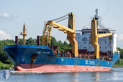
The vessel SIVUMUT (IMO: 9501253, MMSI: 244655000) is a General Cargo that was built in 2010 ( 14 År gammal ). It's sailing under the flag of [NL] Netherlands.
In this page you can find informations about the vessels current position, last detected port calls, and current voyage information. If the vessels is not in coverage by AIS you will find the latest position.
The current position of SIVUMUT is detected by our AIS receivers and we are not responsible for the reliability of the data. The last position was recorded while the vessel was in Coverage by the Ais receivers of our vessel tracking app.
The current draught of SIVUMUT as reported by AIS is 6.3 meters
Weather
| Temperature | 18.5°C / 65.3°F |
|---|---|
| Wind Speed | 4 knots |
| Direction | 203° SSW |
| Pressure | 1010.3 hPa |
| Humidity | 50.5 % |
| Cloud Coverage | 58 % |
Featured Company
Last Port Calls
| Port | Arrival | Departure | Time In Port |
|---|---|---|---|
| 2024-05-14 04:47 | |||
| 2024-05-11 13:19 | 2024-05-12 16:35 | 1 d | |
| 2024-04-24 23:21 | 2024-04-25 06:49 | 7 h | |
| 2024-04-24 18:21 | 2024-04-24 18:49 | 28 m | |
| 2024-04-24 16:33 | 2024-04-24 17:01 | 28 m | |
| 2024-04-23 08:33 | 2024-04-23 08:49 | 15 m | |
| 2024-04-18 17:02 | 2024-04-19 19:10 | 1 d | |
| 2024-04-15 12:44 | 2024-04-18 10:49 | 2 d | |
| 2024-04-05 22:21 | 2024-04-12 23:40 | 7 d | |
| 2024-03-29 07:27 | 2024-03-30 17:21 | 1 d |
Most Visited Ports (Last year)
| Port | Arrivals | |
|---|---|---|
| 4 | ||
| 1 | ||
| 1 | ||
| 1 | ||
| 1 | ||
| 1 |
Last Trips
| Origin | Departure | Destination | Arrival | Distance | |
|---|---|---|---|---|---|
| 2024-05-12 18:35 | 2024-05-14 06:47 | 453.63 nm | |||
| 2024-04-25 02:49 | 2024-05-11 15:19 | 4294.40 nm | |||
| 2024-04-24 14:49 | 2024-04-24 19:21 | 1.07 nm | |||
| 2024-04-24 13:01 | 2024-04-24 14:21 | 0.41 nm | |||
| 2024-04-23 04:49 | 2024-04-24 12:33 | 9.04 nm | |||
| 2024-04-19 15:10 | 2024-04-23 04:33 | 1017.56 nm | |||
| 2024-04-18 06:49 | 2024-04-18 13:02 | 71.61 nm | |||
| 2024-04-12 18:40 | 2024-04-15 08:44 | 816.19 nm | |||
| 2024-03-30 13:21 | 2024-04-05 17:21 | 1689.65 nm | |||
| 2024-03-29 02:53 | 2024-03-29 03:27 | 3.34 nm |
Events
| Tid | Event | Detaljer | Position / Dest | Information |
|---|---|---|---|---|
| 2024-05-14 05:35 | Status ändrad | Moored Under way using engine |
44.40320 / 8.89325
[IT] GENOVA
|
Fart: Kurs: 351° |
| 2024-05-14 05:25 | STOPPAR förflyttning |
44.40305 / 8.89310
[IT] GENOVA
|
Fart: 0.3 kn Kurs: 357° |
|
| 2024-05-14 04:47 | ANLÄNDER HAMN |
|
44.38669 / 8.94642
[IT] GENOVA
|
Fart: 7.5 kn Kurs: 309.1° |
| 2024-05-13 22:31 | Upptäckt i hav | Italian part of the Ligurian Sea |
43.45781 / 8.32866
Ligurian Sea
ITGOA
|
Fart: 12.1 kn Kurs: 49.9° |
| 2024-05-13 20:16 | Byter havsområde | Italian part of the Mediterranean Sea - Western Basin French part of the Mediterranean Sea - Western Basin |
43.15325 / 7.83042
Mediterranean Sea - Western Basin
ITGOA
|
Fart: 12.9 kn Kurs: 49.7° |
| 2024-05-13 19:46 | Byter havsområde | French part of the Mediterranean Sea - Western Basin Mon�gasque part of the Mediterranean Sea - Western Basin |
43.08408 / 7.71711
Mediterranean Sea - Western Basin
ITGOA
|
Fart: 12.8 kn Kurs: 51° |
| 2024-05-13 19:37 | Byter havsområde | Mon�gasque part of the Mediterranean Sea - Western Basin French part of the Mediterranean Sea - Western Basin |
43.06380 / 7.68330
Mediterranean Sea - Western Basin
ITGOA
|
Fart: 12.7 kn Kurs: 50.6° |
| 2024-05-13 18:03 | Status ändrad | Under way using engine Default |
42.84792 / 7.33357
ITGOA
|
Fart: 12.8 kn Kurs: 49° |
| 2024-05-13 18:00 | Status ändrad | Default Under way using engine |
42.84244 / 7.32503
ITGOA
|
Fart: 12.9 kn Kurs: 49.4° |
| 2024-05-13 17:43 | Status ändrad | Under way using engine Default |
42.80256 / 7.25928
ITGOA
|
Fart: 12.7 kn Kurs: 51° |