
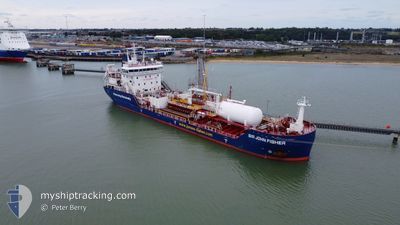
SIR JOHN FISHER
Tanker
Current Trip
| Time Travelled | 3 days |
|---|---|
| Remaining Time | --- |
| Distance Travelled | 391.10 nm |
| Remaining Distance | 4.83 nm |
| AVG Speed | 8 Knop |
| MAX Speed | 11.5 Knop |
| AVG Wind | 19.4 knots |
| MAX Wind | 35 knots |
| MIN Temp | -2.2°C / 28.04°F |
| MAX Temp | 10.5°C / 50.9°F |
| Djupgående | 5.5 m |
| Position mottagen | 2 m sen |
Current Position
| Longitud | --- |
|---|---|
| Latitude | --- |
| Status | At anchor |
| Fart | |
| Kurs | 234° |
| Område | North Sea |
| Station | T-AIS |
| Position mottagen | 2 m sen |
Info
Information
The current position of SIR JOHN FISHER is in North Sea with coordinates 57.55491° / -4.11567° as reported on 2025-01-02 15:35 by AIS to our vessel tracker app. The vessel's current speed is 0 Knop and is heading at the port of INVERNESS. The estimated time of arrival as calculated by MyShipTracking vessel tracking app is 2025-01-01 10:00 LT
The vessel SIR JOHN FISHER (IMO: 9944297, MMSI: 232044985) is a Tanker It's sailing under the flag of [GB] United Kingdom.
In this page you can find informations about the vessels current position, last detected port calls, and current voyage information. If the vessels is not in coverage by AIS you will find the latest position.
The current position of SIR JOHN FISHER is detected by our AIS receivers and we are not responsible for the reliability of the data. The last position was recorded while the vessel was in Coverage by the Ais receivers of our vessel tracking app.
The current draught of SIR JOHN FISHER as reported by AIS is 5.5 meters
Weather
| Temperature | -0.2°C / 31.64°F |
|---|---|
| Wind Speed | 7 knots |
| Direction | 284° WNW |
| Pressure | 1021.7 hPa |
| Humidity | 76.2 % |
| Cloud Coverage | 84 % |
Featured Company
Last Port Calls
| Port | Arrival | Departure | Time In Port |
|---|---|---|---|
| 2024-12-29 12:15 | 2024-12-30 13:14 | 1 d | |
| 2024-12-24 06:14 | 2024-12-27 09:48 | 3 d | |
| 2024-12-21 11:11 | 2024-12-23 11:03 | 1 d | |
| 2024-12-15 03:29 | 2024-12-16 19:56 | 1 d | |
| 2024-12-11 21:29 | 2024-12-13 13:10 | 1 d | |
| 2024-12-08 05:02 | 2024-12-08 19:20 | 14 h | |
| 2024-12-03 05:58 | 2024-12-04 15:19 | 1 d | |
| 2024-11-29 15:36 | 2024-11-30 10:17 | 18 h | |
| 2024-11-27 11:01 | 2024-11-28 12:18 | 1 d | |
| 2024-11-22 04:23 | 2024-11-25 07:22 | 3 d |
Most Visited Ports (Last year)
| Port | Arrivals | |
|---|---|---|
| 38 | ||
| 23 | ||
| 8 | ||
| 6 | ||
| 5 | ||
| 5 |
Last Trips
| Origin | Departure | Destination | Arrival | Distance | |
|---|---|---|---|---|---|
| 2024-12-27 09:48 | 2024-12-29 12:15 | 209.27 nm | |||
| 2024-12-23 11:03 | 2024-12-24 06:14 | 150.63 nm | |||
| 2024-12-16 19:56 | 2024-12-21 11:11 | 396.22 nm | |||
| 2024-12-13 13:10 | 2024-12-15 03:29 | 335.42 nm | |||
| 2024-12-08 19:20 | 2024-12-11 21:29 | 401.85 nm | |||
| 2024-12-04 15:19 | 2024-12-08 05:02 | 333.58 nm | |||
| 2024-11-30 10:17 | 2024-12-03 05:58 | 408.84 nm | |||
| 2024-11-28 12:18 | 2024-11-29 15:36 | 252.83 nm | |||
| 2024-11-25 07:22 | 2024-11-27 11:01 | 392.06 nm | |||
| 2024-11-19 15:28 | 2024-11-22 04:23 | 393.79 nm |
Events
| Tid | Event | Detaljer | Position / Dest | Information |
|---|---|---|---|---|
| 2025-01-02 13:56 | Status ändrad | At anchor Default |
57.55384 / -4.11602
GBINV
|
Fart: 0.1 kn Kurs: 309° |
| 2025-01-02 13:53 | Status ändrad | Default At anchor |
57.55373 / -4.11616
GBINV
|
Fart: Kurs: 317° |
| 2025-01-02 12:56 | Status ändrad | At anchor Default |
57.55456 / -4.11920
GBINV
|
Fart: 0.1 kn Kurs: 76° |
| 2025-01-02 12:53 | Status ändrad | Default At anchor |
57.55451 / -4.11916
GBINV
|
Fart: Kurs: 72° |
| 2025-01-02 12:29 | Status ändrad | At anchor Default |
57.55445 / -4.11890
GBINV
|
Fart: Kurs: 70° |
| 2025-01-02 12:26 | Status ändrad | Default At anchor |
57.55446 / -4.11891
GBINV
|
Fart: 0.1 kn Kurs: 66° |
| 2025-01-02 12:20 | Status ändrad | At anchor Default |
57.55435 / -4.11924
GBINV
|
Fart: Kurs: 75° |
| 2025-01-02 12:17 | Status ändrad | Default At anchor |
57.55433 / -4.11927
GBINV
|
Fart: 0.1 kn Kurs: 85° |
| 2025-01-02 10:20 | Status ändrad | At anchor Default |
57.55405 / -4.11894
GBINV
|
Fart: Kurs: 52° |
| 2025-01-02 10:17 | Status ändrad | Default At anchor |
57.55403 / -4.11883
GBINV
|
Fart: Kurs: 62° |