

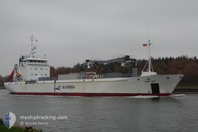
SILVER GALE
Reefer

Current Trip
FORVK
| Time Travelled | 3 days |
|---|---|
| Remaining Time | --- |
| Distance Travelled | 376.05 nm |
| Remaining Distance | --- |
| AVG Speed | 13.1 Knop |
| MAX Speed | 17.6 Knop |
| AVG Wind | 19.3 knots |
| MAX Wind | 29.5 knots |
| MIN Temp | 4°C / 39.2°F |
| MAX Temp | 8.3°C / 46.94°F |
| Djupgående | 4.4 m |
| Position mottagen | 7 d sen |
Current Position
| Longitud | --- |
|---|---|
| Latitude | --- |
| Status | Under way using engine |
| Fart | 14.4 Knop |
| Kurs | 350.7° |
| Område | North Atlantic Ocean |
| Station | T-AIS |
| Position mottagen | 7 d sen |
Information
The current position of SILVER GALE is in North Atlantic Ocean with coordinates 62.02173° / -6.72290° as reported on 2025-03-22 13:38 by AIS to our vessel tracker app. The vessel's current speed is 14.4 Knop
The vessel SILVER GALE (IMO: 9140956, MMSI: 257900000) is a Reefer that was built in 1997 ( 28 År gammal ). It's sailing under the flag of [NO] Norway.
In this page you can find informations about the vessels current position, last detected port calls, and current voyage information. If the vessels is not in coverage by AIS you will find the latest position.
The current position of SILVER GALE is detected by our AIS receivers and we are not responsible for the reliability of the data. The last position was recorded while the vessel was in Coverage by the Ais receivers of our vessel tracking app.
The current draught of SILVER GALE as reported by AIS is 4.4 meters
Weather
| Temperature | 6.6°C / 43.88°F |
|---|---|
| Wind Speed | 23 knots |
| Direction | 184° S |
| Pressure | 1003.6 hPa |
| Humidity | 83.3 % |
| Cloud Coverage | 60 % |


Featured Company
Last Port Calls
| Port | Arrival | Departure | Time In Port |
|---|---|---|---|
| 2025-03-25 13:00 | 2025-03-25 21:05 | 8 h | |
| 2025-03-21 08:07 | 2025-03-22 09:24 | 1 d | |
| 2025-02-28 20:56 | 2025-03-05 12:27 | 4 d | |
| 2025-02-28 19:57 | 2025-02-28 20:42 | 45 m | |
| 2025-02-13 23:36 | 2025-02-23 01:38 | 9 d | |
| 2025-02-04 00:56 | 2025-02-08 15:43 | 4 d | |
| 2025-02-03 23:50 | 2025-02-04 00:42 | 52 m | |
| 2025-01-23 16:15 | 2025-01-29 18:35 | 6 d | |
| 2025-01-16 23:15 | 2025-01-17 15:10 | 15 h | |
| 2025-01-09 20:14 | 2025-01-10 16:15 | 20 h |
Most Visited Ports (Last year)
| Port | Arrivals | |
|---|---|---|
| 5 | ||
| 5 | ||
| 5 | ||
| 3 | ||
| 3 | ||
| 3 |
Last Trips
| Origin | Departure | Destination | Arrival | Distance | |
|---|---|---|---|---|---|
| 2025-03-22 09:24 | 2025-03-25 13:00 | 80.12 nm | |||
| 2025-03-05 12:27 | 2025-03-21 08:07 | 774.40 nm | |||
| 2025-02-28 20:42 | 2025-02-28 20:56 | 1.06 nm | |||
| 2025-02-23 01:38 | 2025-02-28 19:57 | 1602.77 nm | |||
| 2025-02-08 15:43 | 2025-02-13 23:36 | 1613.30 nm | |||
| 2025-02-04 00:42 | 2025-02-04 00:56 | 1.11 nm | |||
| 2025-01-29 18:35 | 2025-02-03 23:50 | 1613.31 nm | |||
| 2025-01-17 15:10 | 2025-01-23 16:15 | 512.93 nm | |||
| 2025-01-10 16:15 | 2025-01-16 23:15 | 1186.38 nm | |||
| 2025-01-06 19:14 | 2025-01-09 20:14 | 889.74 nm |
Events
| Tid | Event | Detaljer | Position / Dest | Information |
|---|---|---|---|---|
| 2025-03-28 15:34 | STARTAR förflyttning | 2.13 nm, North of HOV |
61.53945 / -6.77980
FORVK
|
Fart: 10.2 kn Kurs: 107° |
| 2025-03-26 00:40 | STOPPAR förflyttning | 2.8 nm, North East of FAMJIN |
61.55330 / -6.80779
FORVK
|
Fart: 0.3 kn Kurs: 291° |
| 2025-03-25 21:12 | STARTAR förflyttning | 1.11 nm, North West of KLAKSVIK |
62.24354 / -6.62301
FORVK
|
Fart: 10.7 kn Kurs: 258° |
| 2025-03-25 21:05 | AVGÅTT HAMN |
|
62.24354 / -6.62301
FORVK
|
Fart: Kurs: 3° |
| 2025-03-25 13:00 | STOPPAR förflyttning |
62.25367 / -6.58237
[FO] ANIR
|
Fart: Kurs: 2° |
|
| 2025-03-25 13:00 | ANLÄNDER HAMN |
|
62.25367 / -6.58237
[FO] ANIR
|
Fart: 9.9 kn Kurs: 79° |
| 2025-03-25 10:06 | STARTAR förflyttning | 0.27 nm, North West of TOFTIR |
62.09587 / -6.75173
FORVK
|
Fart: 10.7 kn Kurs: 187° |
| 2025-03-22 14:33 | STOPPAR förflyttning | 0.28 nm, South East of INNAN GLYVUR |
62.12406 / -6.74702
FORVK
|
Fart: 0.2 kn Kurs: 24° |
| 2025-03-22 13:40 | Status ändrad | Default Under way using engine |
62.03000 / -6.72545
FORVK
|
Fart: 14.4 kn Kurs: 350.7° |
| 2025-03-22 13:38 | UTANFÖR täckningsområde |
62.02173 / -6.72290
North Atlantic Ocean
|
Fart: 14.4 kn Kurs: 350.7° |