

SEA HORSE
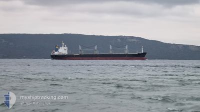
Bulk Carrier

Current Trip
| Time Travelled | 10 days |
|---|---|
| Remaining Time | --- |
| Distance Travelled | 2784.39 nm |
| Remaining Distance | --- |
| AVG Speed | 12.3 Knop |
| MAX Speed | 16 Knop |
| AVG Wind | 17.2 knots |
| MAX Wind | 29.7 knots |
| MIN Temp | 1.7°C / 35.06°F |
| MAX Temp | 16.6°C / 61.88°F |
| Djupgående | 6.4 m |
| Position mottagen | 10 h, 54 m sen |
Current Position
| Longitud | --- |
|---|---|
| Latitude | --- |
| Status | At anchor |
| Fart | |
| Kurs | 260° |
| Område | Gulf of Finland |
| Station | T-AIS |
| Position mottagen | 10 h, 54 m sen |
Information
The current position of SEA HORSE is in Gulf of Finland with coordinates 60.09995° / 29.37572° as reported on 2025-03-26 13:10 by AIS to our vessel tracker app. The vessel's current speed is 0 Knop
The vessel SEA HORSE (IMO: 9528029, MMSI: 314776000) is a Bulk Carrier that was built in 2011 ( 14 År gammal ). It's sailing under the flag of [BB] Barbados.
In this page you can find informations about the vessels current position, last detected port calls, and current voyage information. If the vessels is not in coverage by AIS you will find the latest position.
The current position of SEA HORSE is detected by our AIS receivers and we are not responsible for the reliability of the data. The last position was recorded while the vessel was in Coverage by the Ais receivers of our vessel tracking app.
The current draught of SEA HORSE as reported by AIS is 6.4 meters
Weather
| Temperature | 0.4°C / 32.72°F |
|---|---|
| Wind Speed | 4 knots |
| Direction | 264° W |
| Pressure | 1013.1 hPa |
| Humidity | 87 % |
| Cloud Coverage | 50 % |


Featured Company
Last Port Calls
| Port | Arrival | Departure | Time In Port |
|---|---|---|---|
| 2025-03-16 13:18 | 2025-03-16 20:11 | 6 h | |
| 2025-03-08 14:31 | 2025-03-15 14:23 | 6 d | |
| 2025-02-04 12:23 | 2025-02-15 08:08 | 10 d |
Most Visited Ports (Last year)
| Port | Arrivals | |
|---|---|---|
| 9 | ||
| 2 | ||
| 1 | ||
| 1 | ||
| 1 | ||
| 1 |
Last Trips
| Origin | Departure | Destination | Arrival | Distance | |
|---|---|---|---|---|---|
| 2025-03-15 14:23 | 2025-03-16 13:18 | 252.16 nm | |||
| 2025-02-15 08:08 | 2025-03-08 14:31 | 3510.96 nm | |||
| 2024-12-21 18:07 | 2025-02-04 12:23 | 1621.07 nm |
Events
| Tid | Event | Detaljer | Position / Dest | Information |
|---|---|---|---|---|
| 2025-03-26 13:19 | Status ändrad | Default At anchor |
60.09993 / 29.37582
RU LED
|
Fart: Kurs: 260° |
| 2025-03-26 13:10 | UTANFÖR täckningsområde |
60.09995 / 29.37572
Gulf of Finland
|
Fart: Kurs: 99.8° |
|
| 2025-03-26 12:58 | Status ändrad | At anchor Default |
60.10003 / 29.37575
RU LED
|
Fart: Kurs: 262° |
| 2025-03-26 12:43 | Status ändrad | Default At anchor |
60.09992 / 29.37581
RU LED
|
Fart: Kurs: 262° |
| 2025-03-26 12:31 | Status ändrad | At anchor Default |
60.09998 / 29.37585
RU LED
|
Fart: 0.1 kn Kurs: 255° |
| 2025-03-26 12:16 | I täckningsområde |
60.09998 / 29.37585
Gulf of Finland
|
Fart: Kurs: 135.5° |
|
| 2025-03-25 18:53 | Status ändrad | Default Under way using engine |
60.03856 / 28.55608
RU LED
|
Fart: 13.4 kn Kurs: 98.2° |
| 2025-03-25 18:51 | UTANFÖR täckningsområde |
60.04010 / 28.53541
Gulf of Finland
RU LED
|
Fart: 13.4 kn Kurs: 98.2° |
|
| 2025-03-25 13:40 | Byter havsområde | Russian part of the Gulf of Finland Estonian part of the Gulf of Finland |
59.96219 / 26.40763
Gulf of Finland
RU LED
|
Fart: 13.7 kn Kurs: 75.6° |
| 2025-03-25 13:12 | Status ändrad | Under way using engine Default |
59.93404 / 26.20050
RU LED
|
Fart: 13.7 kn Kurs: 75° |