

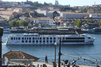
SAO GABRIEL
Passenger

Current Trip
PTGAIA
| Time Travelled | 4 h, 43 mins |
|---|---|
| Remaining Time | --- |
| Distance Travelled | 0.28 nm |
| Remaining Distance | --- |
| AVG Speed | --- |
| MAX Speed | --- |
| AVG Wind | 2.5 knots |
| MAX Wind | 2.5 knots |
| MIN Temp | 17.8°C / 64.04°F |
| MAX Temp | 17.8°C / 64.04°F |
| Djupgående | 1.6 m |
| Position mottagen | 1 m sen |
Current Position
| Longitud | --- |
|---|---|
| Latitude | --- |
| Status | Under way using engine |
| Fart | |
| Kurs | --- |
| Område | North Atlantic Ocean |
| Station | T-AIS |
| Position mottagen | 1 m sen |
Information
The current position of SAO GABRIEL is in North Atlantic Ocean with coordinates 41.13809° / -8.61815° as reported on 2025-03-30 23:18 by AIS to our vessel tracker app. The vessel's current speed is 0 Knop
The vessel SAO GABRIEL (MMSI: 263753860) is a Passenger It's sailing under the flag of [PT] Portugal.
In this page you can find informations about the vessels current position, last detected port calls, and current voyage information. If the vessels is not in coverage by AIS you will find the latest position.
The current position of SAO GABRIEL is detected by our AIS receivers and we are not responsible for the reliability of the data. The last position was recorded while the vessel was in Coverage by the Ais receivers of our vessel tracking app.
The current draught of SAO GABRIEL as reported by AIS is 1.6 meters
Weather
| Temperature | 13.8°C / 56.84°F |
|---|---|
| Wind Speed | 4 knots |
| Direction | 80° E |
| Pressure | 1018.8 hPa |
| Humidity | 60.1 % |
| Cloud Coverage | 6 % |


Featured Company
Last Port Calls
| Port | Arrival | Departure | Time In Port |
|---|---|---|---|
| 2025-03-30 19:21 | 2025-03-30 19:37 | 16 m | |
| 2025-03-25 14:52 | 2025-03-25 14:57 | 4 m | |
| 2025-03-16 12:22 | 2025-03-17 09:08 | 20 h | |
| 2025-01-18 12:56 | 2025-03-16 08:28 |
Most Visited Ports (Last year)
| Port | Arrivals | |
|---|---|---|
| 60 | ||
| 1 |
Last Trips
| Origin | Departure | Destination | Arrival | Distance | |
|---|---|---|---|---|---|
| 2025-03-25 14:57 | 2025-03-30 19:21 | 2.66 nm | |||
| 2025-03-17 09:08 | 2025-03-25 14:52 | 44.44 nm | |||
| 2025-03-16 08:28 | 2025-03-16 12:22 | 25.00 nm | |||
| 2024-11-30 13:26 | 2025-01-18 12:56 | 38.00 nm |
Events
| Tid | Event | Detaljer | Position / Dest | Information |
|---|---|---|---|---|
| 2025-03-30 18:43 | STOPPAR förflyttning | 1.78 nm, East of PORTO |
41.13814 / -8.61819
PTGAIA
|
Fart: 0.3 kn Kurs: 511° |
| 2025-03-30 18:37 | AVGÅTT HAMN |
|
41.14153 / -8.62225
PTGAIA
|
Fart: 6.9 kn Kurs: 128° |
| 2025-03-30 18:21 | ANLÄNDER HAMN |
|
41.14700 / -8.64401
[PT] PORTO
|
Fart: 11.7 kn Kurs: 260.3° |
| 2025-03-30 18:15 | STARTAR förflyttning | 1.68 nm, East of PORTO |
41.13992 / -8.61999
PTGAIA
|
Fart: 10.8 kn Kurs: 312° |
| 2025-03-27 19:41 | Status ändrad | Under way using engine Default |
41.13792 / -8.61829
PTGAIA
|
Fart: Kurs: -1° |
| 2025-03-27 19:31 | Status ändrad | Default Under way using engine |
41.13789 / -8.61827
PTGAIA
|
Fart: Kurs: 511° |
| 2025-03-25 15:02 | STOPPAR förflyttning | 1.83 nm, East of PORTO |
41.13793 / -8.61712
PTGAIA
|
Fart: 0.3 kn Kurs: 511° |
| 2025-03-25 14:57 | AVGÅTT HAMN |
|
41.14149 / -8.62246
PTGAIA
|
Fart: 7.3 kn Kurs: 127.6° |
| 2025-03-25 14:52 | ANLÄNDER HAMN |
|
41.14450 / -8.63234
[PT] PORTO
|
Fart: 1.3 kn Kurs: 511° |
| 2025-03-25 12:31 | I täckningsområde |
41.05540 / -8.45092
North Atlantic Ocean
|
Fart: 9.1 kn Kurs: 315.5° |