
RAPIDO
Cargo
Current Trip
| Time Travelled | 5 days |
|---|---|
| Remaining Time | 6 h, 20 mins |
| Distance Travelled | 146.40 nm |
| Remaining Distance | 46.44 nm |
| AVG Speed | 6.8 Knop |
| MAX Speed | 10 Knop |
| AVG Wind | 14.1 knots |
| MAX Wind | 24 knots |
| MIN Temp | 4.5°C / 40.1°F |
| MAX Temp | 15.7°C / 60.26°F |
| Djupgående | 0.4 m |
| Position mottagen | 1 m sen |
Current Position
| Longitud | 5.67380° |
|---|---|
| Latitude | 52.84644° |
| Status | Under way using engine |
| Fart | 3.1 Knop |
| Kurs | 21.1° |
| Område | North Sea |
| Station | T-AIS |
| Position mottagen | 1 m sen |
Info
Information
The current position of RAPIDO is in North Sea with coordinates 52.84644° / 5.67380° as reported on 2024-04-29 12:15 by AIS to our vessel tracker app. The vessel's current speed is 3.1 Knop and is heading at the port of GRONINGEN. The estimated time of arrival as calculated by MyShipTracking vessel tracking app is 2024-04-29 18:37 LT
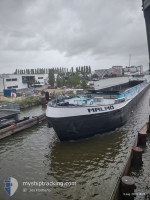
The vessel RAPIDO (MMSI: 244710320) is a Cargo It's sailing under the flag of [NL] Netherlands.
In this page you can find informations about the vessels current position, last detected port calls, and current voyage information. If the vessels is not in coverage by AIS you will find the latest position.
The current position of RAPIDO is detected by our AIS receivers and we are not responsible for the reliability of the data. The last position was recorded while the vessel was in Coverage by the Ais receivers of our vessel tracking app.
The current draught of RAPIDO as reported by AIS is 0.4 meters
Weather
| Temperature | 15.9°C / 60.62°F |
|---|---|
| Wind Speed | 10 knots |
| Direction | 212° SSW |
| Pressure | 1019.4 hPa |
| Humidity | 59.7 % |
| Cloud Coverage | 1 % |
Featured Company
Last Port Calls
| Port | Arrival | Departure | Time In Port |
|---|---|---|---|
| 2024-04-23 18:34 | 2024-04-23 18:58 | 24 m | |
| 2024-04-23 15:02 | 2024-04-23 15:52 | 49 m | |
| 2024-04-23 10:51 | 2024-04-23 13:25 | 2 h | |
| 2024-04-23 01:32 | 2024-04-23 09:32 | 8 h | |
| 2024-04-22 23:47 | 2024-04-23 00:08 | 20 m | |
| 2024-04-22 20:22 | 2024-04-22 21:17 | 55 m | |
| 2024-04-19 06:45 | 2024-04-22 03:45 | 2 d | |
| 2024-04-13 12:04 | 2024-04-13 13:12 | 1 h | |
| 2024-04-13 09:51 | 2024-04-13 10:29 | 38 m | |
| 2024-04-13 03:20 | 2024-04-13 08:36 | 5 h |
Last Trips
| Origin | Departure | Destination | Arrival | Distance | |
|---|---|---|---|---|---|
| 2024-04-23 17:52 | 2024-04-23 20:34 | 18.45 nm | |||
| 2024-04-23 15:25 | 2024-04-23 17:02 | 9.40 nm | |||
| 2024-04-23 11:32 | 2024-04-23 12:51 | 13.32 nm | |||
| 2024-04-23 02:08 | 2024-04-23 03:32 | 12.86 nm | |||
| 2024-04-22 23:17 | 2024-04-23 01:47 | 11.76 nm | |||
| 2024-04-22 05:45 | 2024-04-22 22:22 | 71.49 nm | |||
| 2024-04-13 15:12 | 2024-04-19 08:45 | 128.17 nm | |||
| 2024-04-13 12:29 | 2024-04-13 14:04 | 11.20 nm | |||
| 2024-04-13 10:36 | 2024-04-13 11:51 | 13.08 nm | |||
| 2024-04-13 03:43 | 2024-04-13 05:20 | 13.01 nm |
Events
| Tid | Event | Detaljer | Position / Dest | Information |
|---|---|---|---|---|
| 2024-04-29 11:59 | ETA ändrat | 2024/04/29 16:36 2024/04/29 22:27 |
52.83036 / 5.65069
ADUARD
|
Fart: 6.2 kn Kurs: 68° |
| 2024-04-29 10:43 | ETA ändrat | 2024/04/29 22:27 2024/04/29 19:53 |
52.75623 / 5.45714
ADUARD
|
Fart: 6.8 kn Kurs: 72.6° |
| 2024-04-29 10:41 | ETA ändrat | 2024/04/29 19:53 2024/04/29 16:36 |
52.75542 / 5.45262
ADUARD
|
Fart: 6.9 kn Kurs: 74.3° |
| 2024-04-29 10:24 | STARTAR förflyttning | 4.92 nm, North East of ENKHUIZEN |
52.74800 / 5.40552
ADUARD
|
Fart: 3.3 kn Kurs: 82.2° |
| 2024-04-29 10:18 | Status ändrad | Under way using engine Moored |
52.74638 / 5.40532
ADUARD
|
Fart: Kurs: 511° |
| 2024-04-29 09:50 | Status ändrad | Moored Default |
52.74588 / 5.40464
ADUARD
|
Fart: 0.1 kn Kurs: -1° |
| 2024-04-29 09:45 | Status ändrad | Default Moored |
52.74582 / 5.40465
ADUARD
|
Fart: Kurs: 511° |
| 2024-04-29 09:40 | Status ändrad | Moored Default |
52.74587 / 5.40483
ADUARD
|
Fart: 0.1 kn Kurs: -1° |
| 2024-04-29 09:32 | Status ändrad | Default Moored |
52.74583 / 5.40468
ADUARD
|
Fart: Kurs: 511° |
| 2024-04-29 09:12 | Status ändrad | Moored Under way using engine |
52.74584 / 5.40463
ADUARD
|
Fart: Kurs: 511° |